Toronto Ontario Line 3 | ?m | ?s

West of the Don, Tory's SmartTrack map shows a stop at Dundas West, Liberty Village, Spadina, Union, and then nothing until it crosses the Don at UniLever. It doesn't intercept Line 2 until Main Street. So I don't quite understand how they are competing. They seem to serve different markets.
 
They shouldn't spend and more money studying the DRL for at least the next 10 years.

ST is on it's way and will use the rail corridor with closer inner city stations and due to interlining those areas will enjoy subway service and not just subway speed. ST could end up being so successful by that they may find that a DRL may not even be necessary. I thinks it's obvious that all of Toronto's current GO corridors will eventually turned into ST serving the 416. The huge passenger loads they carry may sufficiently relieve Yong and especially Y&B station.

Eventually if trains from ST and GO serving Union become so frequent that delays begin then they should look at a ST tunnel for a few of the ST routes and the obvious best choice is Queen.

Before the City starts pouring billions into a DRL they should wait til ST is fully built out so they can determine the best route or if it's even needed.
 
Every potential station along a Queen Street alignment would be high-density and have trip-generators close by:

Roncesvalles - St Joseph Hospital, shopping district, major interchange with GO and streetcar routes to the west
Jameson - apartrment buildings extend all the way up the street to Queen and West Lodge (just north of Queen) has that large building complex as well
Dufferin - major interchange with GO/RER; several condos; Gladstone Hotel
Ossington - Drake Hotel; CAMH; Art and Design District
Niagara - Trinty-Bellwoods Park, several apartments on Stanley; condos/townhouses near Strachan/Queen
Bathurst - Alexandra Park priority neighbourhood; several office buildings near Bathurst/Richmond
Spadina - Fashion District, Chinatown south
Osgoode - MuchMusic, OCAD, Opera House
Bay-Yonge - City Hall, Sheraton Centre, Eaton Centre, Financial District, St Micheal's Hospital
Jarvis - Moss Park, with a PATH connection easy walk of George Brown College
Parliament - Regent Park apartments, easy walk of Cabbagetown
River - north end of West Don Lands; GO connection
Broadview - condos, Riverside shopping district
Carlaw - lots of gentrification potential; major transfer for points east along Queen/Kingston

We'd ignore all this to route a DRL underneath a mere few hundred metres north of the rail corridor (King or Wellington); which is already getting a subwaylike service in SmartTrack. Like someone here said before, we risk the same quagmire as the Scarborough Subway vs. SmartTrack debate whereby the lines route too close to each other and thus directly compete with each other for ridership.

On the same vein, I wonder if they're considering SmartTrack effects on the Relief Line, it seems like it would make most sense to put the DRL as north as possible.
 
West of the Don, Tory's SmartTrack map shows a stop at Dundas West, Liberty Village, Spadina, Union, and then nothing until it crosses the Don at UniLever. It doesn't intercept Line 2 until Main Street. So I don't quite understand how they are competing. They seem to serve different markets.

SmartTrack isn't that well thought out in the core. Three stations (Gerrard, Queen East, Unilver) within a mile, then nothing in the area along West Don Lands and the lakeshore. Now, if it morphed into a longer tunnel with more stations along the way, it really could service the areas along the railway/Front Corridor, but with heavy rail and long trains, that would cost a few billions, and then the DRL would likely be punted down the road.

RER was really designed to get suburbanites into the core, and SmartTrack to get them to vote for Tory. Neither is designed to help out mobility very much within the core.
 
^While RER likely won't have stations as close together as the subway system, it will be very useful to people in the parts of the core near a station as long as fares are integrated. Exhibition Station could be a major transit hub for the west end of the core, and a potential station in the West Don Lands area could be a major hub in the east end. A good RER system is useful to anyone who's near a station, not just suburbanites.

West of the Don, Tory's SmartTrack map shows a stop at Dundas West, Liberty Village, Spadina, Union, and then nothing until it crosses the Don at UniLever. It doesn't intercept Line 2 until Main Street. So I don't quite understand how they are competing. They seem to serve different markets.
Tory's SmartTrack map is little more than a doodle on the back of a napkin. Where he proposed the line and stations doesn't really mean much. As the public information session notice shows, the different downtown transit projects aren't being looked at in isolation. Smarttrack is being reviewed along with RER and the relief line. Since Smarttrack and GO RER are essentially the same thing, I think that Smarttrack will just get rolled into the RER system.
 
Last edited:
SmartTrack isn't that well thought out in the core. Three stations (Gerrard, Queen East, Unilver) within a mile, then nothing in the area along West Don Lands and the lakeshore. Now, if it morphed into a longer tunnel with more stations along the way, it really could service the areas along the railway/Front Corridor, but with heavy rail and long trains, that would cost a few billions, and then the DRL would likely be punted down the road.

RER was really designed to get suburbanites into the core, and SmartTrack to get them to vote for Tory. Neither is designed to help out mobility very much within the core.

SmartTrack at the railway corridor doesn't serve the west shoulder area of downtown well at all. You know, the area that has two streetcar lines that already have proven demand and carry nearly 100,000 people a day along a corridor that gets people to where they want to go. Like you said, trying to pigeon-hole SmartTrack into a service that serves the shoulder areas and somehow serves the 905 seems like a great way to water down express rail into something useless.

While RER likely won't have stations as close together as the subway system, it will be very useful to people in the parts of the core near a station as long as fares are integrated. Exhibition Station could be a major transit hub for the west end of the core, and a potential station in the West Don Lands area could be a major hub in the east end. A good RER system is useful to anyone who's near a station, not just suburbanites.
SmartTrack doesn't go to Exhibiton Station.
 
I like option D as well but routing will need to be careful.

One thing to note. A couple months back in conversation with some of the TTC staff and engineering experts. they noted that tunneling under the west don lands was tricky on two accounts. Firstly, Corktown Common and other parts of the West Don Lands area were placed on foundation stilts that run down to bed rock and there weren't necessarily given any strategic gaps or corridors purposely created to thread a subway through them in the future.

Secondly, tunneling through a flood protection berm mitigates the value and use of a flood protection berm.
Same goes for any sort of penetration of the rail berm, be it by stations or tunnels etc. The rail berm is part of the flood protection system.

Another key factor was the depth of stations required should stations be wanted here. building stations and tunnels deep enough into bed rock so as not to compromise the flood protection means added costs to station construction. Additionally to meet fire safety standards and facilitate connection of people to the surface and other intersecting services eg SmartTrack they would need high speed elevators to e able to clear the platforms and station in a sufficient amount of time. these things add big to the price tag as we can all imagine

Sounds about right.

I personally believe that they are leaning towards Corridor D, but Corridor B is also a worthy contender IMO

Corridor A is a clear loser. It provides zero neighbourhood access East of the Don. No connection to GO RER or SmartTrack. Does not support future development in the West Don Lands that we know will happen. No direct connection to Greenwood. And no connection to Unilever. With Tory as Mayor, and him being best buds with First Gulf, can you imagine them not lobbying him for a DRL connection? Please. I can't see this one going forward.

I wouldn't say it's a "loser". There are four alignments, which were whittled down from dozens of combinations. Option A has its merits, obviously. It wouldn't have been chosen if it didn't.

As for other posts thinking we'll have an intercept station at Queen and the Don River for a GO Richmond Hill line...yeah, that's not happening. There's no space for an RH platform. And even if there was, we wouldn't be allowed to build a station next to the volatile Don this far south. Nor are we going to have DRL stations every few hundred metres for that matter. This is a very costly project, one of many this city is undertaking. If the RL is even fortunate enough to make it farther into the planning stages, I think we'd be lucky to see only two stations between Yonge and the Danforth.

Re: "future development in the WDL"...the area's development is pretty much finishing up. We're not going to see any added proposals there anyways. No doubt for areas beyond WDL's periphery along Queen E, King, and River. But not inside. And interestingly, one of the reasons for the original DRL was to spur development on these lands. Turns out it wasn't even needed.
 
I wouldn't say it's a "loser". There are four alignments, which were whittled down from dozens of combinations. Option A has its merits, obviously. It wouldn't have been chosen if it didn't.
Clearly it has some merits. But I still think it is a clear loser of the four options.

Re: "future development in the WDL"...the area's development is pretty much finishing up. We're not going to see any added proposals there anyways. No doubt for areas beyond WDL's periphery along Queen E, King, and River. But not inside. And interestingly, one of the reasons for the original DRL was to spur development on these lands. Turns out it wasn't even needed.
I see this trumped up a lot and it is a sort of circular reason that kind of ignores some simple realities. Real estate demand has become so fierce in Toronto that developers are pushing ahead with projects ahead of infrastructure. However, that doesn't mean that the infrastructure isn't needed. Concluding that because development has occurred, that the infrastructure was unnecessary is a clear fallacy. Look at Humber Bay for a great example.

When I say that it "supports future development", I don't mean that it will somehow convince developers to build more condos. I mean that it will support the people that live there in the future in transit bereft new developments that are going to happen regardless.
 
Clearly it has some merits. But I still think it is a clear loser of the four options.


I see this trumped up a lot and it is a sort of circular reason that kind of ignores some simple realities. Real estate demand has become so fierce in Toronto that developers are pushing ahead with projects ahead of infrastructure. However, that doesn't mean that the infrastructure isn't needed. Concluding that because development has occurred, that the infrastructure was unnecessary is a clear fallacy. Look at Humber Bay for a great example.

When I say that it "supports future development", I don't mean that it will somehow convince developers to build more condos. I mean that it will support the people that live there in the future in transit bereft new developments that are going to happen regardless.

New transportation infrastructure is definitely needed. But it wasn't needed to spur development in this area. Zoning and high property values were already in place to bring in private investment. And the Prov got the ball rolling with Pan Am as the catalyst, and the subsequent funds to build the flood protection landform / clean the polluted property. Long and short, the DRL wasn't needed to see Atiratari come back to life.
 
SmartTrack doesn't go to Exhibiton Station.

Again, Smarttrack is just a conceptual line on a map. If it gets rolled into GO RER as it should, then where Tory's election map shows the line won't mean anything. Exhibition Station is very much on the RER network.
 
SmartTrack isn't that well thought out in the core. Three stations (Gerrard, Queen East, Unilver) within a mile, then nothing in the area along West Don Lands and the lakeshore. Now, if it morphed into a longer tunnel with more stations along the way, it really could service the areas along the railway/Front Corridor, but with heavy rail and long trains, that would cost a few billions, and then the DRL would likely be punted down the road.

RER was really designed to get suburbanites into the core, and SmartTrack to get them to vote for Tory. Neither is designed to help out mobility very much within the core.

ST will do a lot more for the core than Miller's Transit City which completely ignored the downtown area. The only thing they could look forward to was the West LRT which was by no means rapid transit.

Urban dwellers are getting infinitely better transit under Tory's ST than Miller's TC.
 
Bingo!

I just whipped this map up for scrutiny:


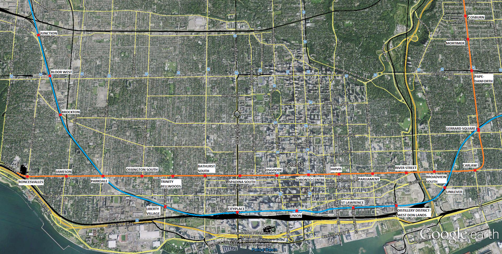
Wow, great map. I would be so happy if this is what actually gets built, with that exact stop spacing (both for the DRL and GO-RER). The core would have such good coverage. What you've shown looks very much like the historical proposals for the Queen line.

I think with Smarttrack in the mix, the Queen/Pape (Corridor B) is the best choice now, as you don't want the services competing (like with Smarttrack/Scarb subway) and it makes two alternatives for downtown located in the city in different areas. Also, that alignment seems to have the highest ridership per stop (all green) It also connects to the Lakeshore GO Line, which would create a mobility hub and take the load off Union (people would get off here and transfer to DRL to get to downtown)

+1

I personally believe that they are leaning towards Corridor D, but Corridor B is also a worthy contender IMO
+1
Corridor A is a clear loser. It provides zero neighbourhood access East of the Don. No connection to GO RER or SmartTrack. Does not support future development in the West Don Lands that we know will happen. No direct connection to Greenwood. And no connection to Unilever. With Tory as Mayor, and him being best buds with First Gulf, can you imagine them not lobbying him for a DRL connection? Please. I can't see this one going forward.

Yeah, but it's the cheapest, so it has that going for it. Also, I feel like these reports are supposed to have options that can easily be eliminated to make the remaining options look better.

From what has been presented, I think option B with a downtown alignment along Richmond or Adelaide is the way to go. Hopefully they would be able to tunnel between the supports for both the Queen bridge and the FPL. Station box construction for the CBD station would be less disruptive on one of those streets than Queen or King. It also maintains a distance between the Relief Line and the RER.

I thought that, based on their preferred station locations, Adelaide had been disfavoured compared to Queen and King. I think that the construction is going to significantly disrupt the streetcar lines regardless of which corridor is chosen, and that it's better to endure the short-term pain of construction for the long-term gain of convenient connections than to pick a route that only approximates where people want to go. Plus, I'm pretty sure an adelaide alignment would mean both the Queen and King streetcars would be eliminated.

In my transit-world fantasy, while station construction is going on at Queen, streetcars are routed through King, which has been turned into a transit mall to handle the additional streetcar traffic (or vice-versa, if King is chosen for the DRL). After the line has been constructed, service is permanently ended on Queen (or King) and the transit mall stays, with the additional streetcars redeployed from Queen (or King).

On the same vein, I wonder if they're considering SmartTrack effects on the Relief Line, it seems like it would make most sense to put the DRL as north as possible.
+1
As for other posts thinking we'll have an intercept station at Queen and the Don River for a GO Richmond Hill line...yeah, that's not happening. There's no space for an RH platform. And even if there was, we wouldn't be allowed to build a station next to the volatile Don this far south.
I had the impression that the station would be at River street, not directly next to the Don. The connection to the RH line isn't the best, but flooding shouldn't be an issue.
Nor are we going to have DRL stations every few hundred metres for that matter. This is a very costly project, one of many this city is undertaking. If the RL is even fortunate enough to make it farther into the planning stages, I think we'd be lucky to see only two stations between Yonge and the Danforth.

That sounds like a pretty awful scenario. For a subway line, the costs are with the tunnelling, the benefits are with the stations. I hope that we don't go through the massive multi-billion dollar expense of a DRL just to build a shuttle between the Danforth line and the CBD, because we'd rather save a couple hundred million than serve the shoulder areas of downtown.
 
New transportation infrastructure is definitely needed. But it wasn't needed to spur development in this area. Zoning and high property values were already in place to bring in private investment. And the Prov got the ball rolling with Pan Am as the catalyst, and the subsequent funds to build the flood protection landform / clean the polluted property. Long and short, the DRL wasn't needed to see Atiratari come back to life.

Clearly, you didn't comprehend what I wrote.

Yes, transit infrastructure is definitely needed. Yes, it isn't needed to spur development. That is true of almost everywhere in the City of Toronto. Development is going to happen regardless of transit, because developers want to make money. However, that doesn't mean that planned transit infrastructure (such as the DRL) is unnecessary for the east side of downtown. Like you said, these areas are coming back to life, despite the lack of high-order transit. But I'd argue that is not necessarily a good thing.

This is why the comment you made about seeing two stations between Yonge and the Danforth is sheer lunacy. That kind of subway would be nothing but an expensive shuttle service that doesn't service local populations at all, which is a service that would be better off being provided by GO. Even a relief line with six stops from Pape to Yonge&Queen or Yonge&King would be faster than transferring at Yonge & Bloor.
 
Last edited:
I personally vote for Option B or D, with my preference being "B". Every time I've ridden the Queen Streetcar it's been out-of-control packed, and also stuck in traffic. Plus I think it's smart for the city to have the line intersect all the highlights like the Eaton Centre, City Hall, Queen West, West Queen West, etc. Queen West is always busy and now with the Ossington area being such a trendy place it's jammed too. I also like it being slightly north. King seems too close to Union, RER, etc. This would benefit both locals and tourists all days of the week, whereas King through the core benefits the Financial District during the week and is a ghost town on weekends.

I used to work at Don Mills and Eglinton and riding the Pape bus from Bloor up was a nightmare. Also always packed. So I love the idea of the DRL crossing at Pape and eventually making it's way up Pape, across Overlea and up Don Mills until it intersects with...whatever transit line ends up crossing Don Mills.

I don't think Broadview works because you can have people from the east of Broadview come to the line, but west of Broadview is mostly just the valley. Whereas on Pape, people can come from both west and east of Pape to catch this line.
 
Ding ding ding - the DRL (unlike Smarttrack) should not be simply about relieving the Yonge line - it should be designed in a way to a) maximize relief for the litany of surface routes that is experiencing overcrowding and service reliability issues; b) support future urban development patterns. Design a subway line to maximize the benefits of that mode.

AoD
 

Back
Top