Toronto Ontario Line 3 | ?m | ?s

Why is going to Dundas West / Bloor Subway so important for the Western Extension?

I see it as an argument if you want to build the subway out to Mount Dennis and begin relieving the University line. However, there is much greater density being underserved by transit by Humber Bay Shores.

This is one of the reasons I'd like for the City/TTC to explore branching of any new line. Hypothetically we could build to both destinations/termini with same line, or have the typical DRL U while also serving future growth in the eastern and western waterfronts.

Naturally creating wyes, flyovers, flyunders etc will up the cost of any project; but the savings can be brought about by using a branch in place of other new infrastructure projects. Or only building single track and passing tracks for the lesser-used branch. With the dynamics of shifting growth / commuting / development patterns, automated operation can be tuned accordingly to address these changes over time.
 
Just pointing out that we won't have a transit friendly Federal government and Provincial government forever. If we were in France or the U.K, I'd feel comfortable with the phasing. But in this political environment, the 50% funding for shovel ready projects from the Federal government is more likely a 1 time thing that we wont see until the next generation.

Therefore, the focus should have been on submitting the whole line in one shot. Taking a wild number like $20B, means that the Feds would pay $10B for the DRL, leaving the province and the city with the balance, which happens to be on Metrolinx list and a Liberal promise.

You think federal gov’t will give 10B to Toronto. That’s a lot of money for one region. But if true, for sure they need to rush in and have it shovel ready with TBM at least a year prior to the next provincial election
 
I agree that an initial L, U, or J shape to the DRL doesn't prevent the addition of branches later on. I don't know why this is a novel idea in Toronto. In New York it's typical to have multiple trains with different destinations sharing the same lines and stations. For example, the '3 Train' from Pape might go to Dundas West while the '6Train' from Pape might go to Front and Bathurst or Sunnyside. Branches are common in other systems.
 
If anything, DRL west should continue west south of High Park to Humber Shores, down to Mimico/Long Branch and then over to Sherway. This would allow great densification along the waterfront.

It doesn't necessarily need to connect back up to Bloor. There is already the Roncesvalles streetcar corridor and many other transit connections that go north-south.

This could also act as a big Carpool centre at Sherway, getting many drivers from the West GTA off of Toronto roads.

In terms of relieving the Yonge line downtown and capturing riders from the north west, the TYSSE subway, GO RER/Smart Track, Eglinton Crosstown West, and UPX can all do this.

Has this option been considered? I'm probably wrong...but it seems worthwhile to investigate.
 
Last edited:
Screen shot 2016-06-28 at 8.52.44 PM.png
 

Attachments

  • Screen shot 2016-06-28 at 8.52.44 PM.png
    Screen shot 2016-06-28 at 8.52.44 PM.png
    21.2 KB · Views: 851
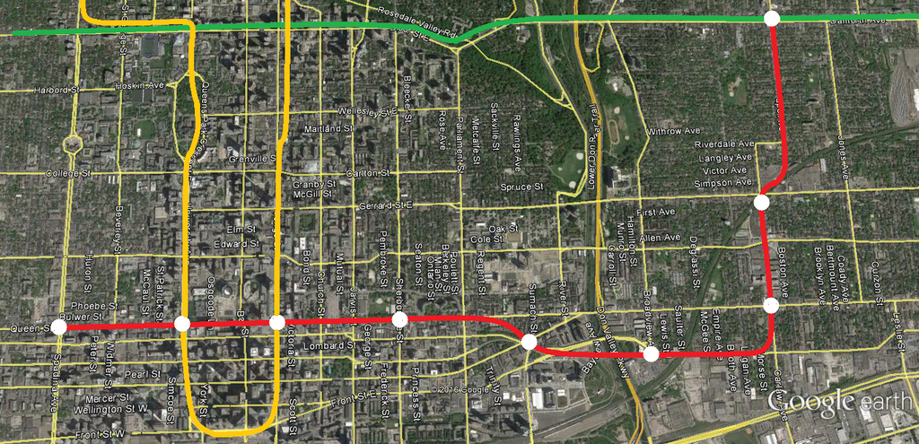
Then again for your consideration, I present to the forum a Carlaw alignment:


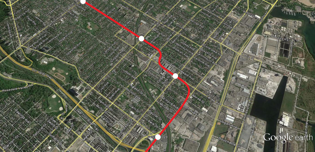
A lot of NIMBY accusations on this one, but I agree with them. It isn't about a subway running under a low-density neighbourhood; whoop-dee-doo. It's about the station location. Subway stations should strive to be on roads with higher densities, in this case being Carlaw. Carlaw has significant mixed use north of Queen, and even a couple lots prime for re-development. While it may slow down the train a little bit (which could be mitigated with gentler curves than what Hopkins123 has illustrated), it put more people in closer proximity to the station for work and home.

While in many cases it is, NIMBY this is not.
 
Saw that one coming. Her office must have been inundated with calls and emails.

At the last meeting she announced she'd do this (to much applause). I know from reading this thread that those pushing for the Pape->Carlaw alignment are considered a bunch of clueless NIMBYs. While part of that might be true (with some at the meeting making odd claims like dust harming children), many actually made quite valid, well-thought points. And the City/TTC wasn't able to answer some of these. I know one of emcees was chastised for saying something to the tune of 'well then you should speak to a real estate professional to get an answer'. She later apologized for this.

Realistically though it does make sense. The 72 route follows Carlaw-Pape, Carlaw has a wider ROW south of Riverdale Av, and Carlaw along this stretch is obviously more developable.

I would think putting the Gerrard station in the jog under or alongside the railway line would make more sense and slow the trip down less.

This is what I'm thinking as well. I've tried to map it using the proper turning radii, but this required the Gerrard station to be more south of Gerrard/Carlaw than would be optimal. And I also attempted to see if it could work to have the station box aligned below the rail corridor between Pape and Carlaw. However this seemingly would require a larger hairpin-type curve on the approaches to the station. I gave up on it, tho may try again. But I think the City/TTC could come up with something.
 
Putting the station parallel to the railway corridor is almost certainly a non-starter. A station platform is 500 feet long, and once you fill out all of the ancilliary systems that need to be installed in the station you're looking at a station box approaching 600 feet.

The distance between Carlaw and Pape via the railway tracks is give-or-take 835 feet. That doesn't give much distance at all to deal with the curves leading to and from the north-south alignment.

Dan
Toronto, Ont.
 
what if they swing the line over to Carlaw north of the railway corridor? ...so that it bisects riverdale or langley on that map that Hopkins posted

if i'm not mistaken, the city identified the lands immediately northwest of the railway corridor as a potential redevelopment site.... with a future road to boot! seems like disruption/property issues could be resolved/secured through that development approval process
 
Something more along the lines of this could work, with the Gerrard Station occuring south of Gerrard:


Woul it be possible to to run subway in a circle? DRL red line show above on going north and then on Green blue line ? NYC has similar system where different trains sue the same track?
 

Back
Top