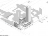
Toronto 309 Cherry Street | 151.35m | 47s | Castlepoint Numa | SvN

Oh jeeze this is in the Portlands.. Ok. I thought it was a site in the Pan Am village area. Yea, this is a whiles off yet, and is probably a rezoning exercise, not an actual final design.
 
I too thought it was in the West Don Lands.

Even though it is still a long ways away, I just hope the Portlands are done right. It constitutes a large geographic area that borders the lake, pretty unique for the city. Future generations of Torontonians will either be grateful or resent us for screwing it up.
 
309 CHERRY ST
Ward 30 - Tor & E.York District

►View All Properties

Zoning By-law and Official Plan Amendment to permit the redevelopment of the site for an 11-storey mid-rise building along Old Cherry Street, one 52-storey tall building atop a podium base ranging in height from 4 to 12-storeys along Commissioners Street and Foundry Street, the creation of a 15 metres east-west private road along the north portion of the site and publicly accessible open space in the interior of the site.
Proposed Use --- # of Storeys --- # of Units ---
 
My understanding is that Helicopters are more conical than planes, which are restricted to runway approach angles.

I've dealt a small bit with Downsview flight path restrictions, and they run out relatively linearly away from the runway ends IIRC.
 
I would think that this comes pretty close to the airport's flight paths but this document from Porter seems to disagree:

https://www1.toronto.ca/City Of Toronto/Waterfront Secretariat/Shared Content/Files/BBTCA/Porter Airlines/porter-flight-paths-presentation.pdf

The building is literally at the end of the projection of runway 26 on the take-off path. The plane has to swerve right-ward over the harbour to escape over Cherry Beach and avoid collinding with a building in its path.
 
I'm not sure you're reading the map / diagram on p.7 correctly. It indicates that planes on both arrival and departure wouldn't come anywhere near this site.
 
I'd be less confused by the description from the dev app site (as it pertains to potential flight path considerations) if it contemplated the tower to be situated closer to the northern edge of the site, which is nearly across the street (at least thinking about the edge of the loop of the flight path) from these:

Screen Shot 2017-01-02 at 10.33.09 PM.png
 

Attachments

  • Screen Shot 2017-01-02 at 10.33.09 PM.png
    Screen Shot 2017-01-02 at 10.33.09 PM.png
    850.6 KB · Views: 568
I don't recall a Porter plane going north of Polson Pier to take off or land, but no there 7/24 to vilify it. Usually, they are around the shipping channel or south of it and well south of the site.
 
I don't recall a Porter plane going north of Polson Pier to take off or land, but no there 7/24 to vilify it. Usually, they are around the shipping channel or south of it and well south of the site.

Yeah, that's definitely the case (and I've flown that route many times myself); I think the question surrounds what the prescribed/enumerated flight path is rather than the typical route itself -- i.e. presumably (and hopefully), there's a buffer zone away from their regular route into or away from the runway.
 
Developer is Casltepoint Numa, architect is SvN:
upload_2017-1-25_16-21-0.png


upload_2017-1-25_16-21-29.png


upload_2017-1-25_16-22-0.png


upload_2017-1-25_16-22-33.png


upload_2017-1-25_16-23-7.png


upload_2017-1-25_16-23-37.png


upload_2017-1-25_16-24-1.png


upload_2017-1-25_16-25-5.png


This application pertains to Phase 2:
upload_2017-1-25_16-28-9.png
 

Attachments

  • upload_2017-1-25_16-21-0.png
    upload_2017-1-25_16-21-0.png
    356.4 KB · Views: 617
  • upload_2017-1-25_16-21-29.png
    upload_2017-1-25_16-21-29.png
    348.1 KB · Views: 615
  • upload_2017-1-25_16-22-0.png
    upload_2017-1-25_16-22-0.png
    661.4 KB · Views: 556
  • upload_2017-1-25_16-22-33.png
    upload_2017-1-25_16-22-33.png
    744.8 KB · Views: 562
  • upload_2017-1-25_16-23-7.png
    upload_2017-1-25_16-23-7.png
    611.2 KB · Views: 588
  • upload_2017-1-25_16-23-37.png
    upload_2017-1-25_16-23-37.png
    593 KB · Views: 542
  • upload_2017-1-25_16-24-1.png
    upload_2017-1-25_16-24-1.png
    632.5 KB · Views: 549
  • upload_2017-1-25_16-25-5.png
    upload_2017-1-25_16-25-5.png
    197.8 KB · Views: 567
  • upload_2017-1-25_16-28-9.png
    upload_2017-1-25_16-28-9.png
    1.2 MB · Views: 561
SvN does some good work, but I really can't parse what's going on here. It looks... like a big above-ground parking garage??

Zoning By-law amendment to permit the redevelopment of the site for an 11-storey building along Cherry Street, one 52-storey tall building atop a podium base ranging in height from 4 to 12-storeys along Commissioners Street, the creation of a 15 metres east-west private road along the north portion of the site and publicly accessible open space in the interior of the site. The development proposal comprises 73,037.8 square metres of gross floor area, resulting in a density of 7.26 times the area of the lot and includes 1,013 residential units and 1,833.8 square metres of non-residential space.
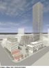
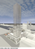
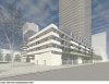
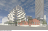
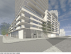
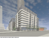
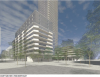
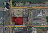
Over 1k residential units, here of all places? This must be a zoning exercise.
 
Last edited:

Back
Top