News   Apr 16, 2024
 277     0 
News   Apr 16, 2024
 712     3 
News   Apr 16, 2024
 485     3 

Parliament Streetcar

I still think I was onto something here.
It's tricky, because you can't run straight across from Parliament to the northside of Bloor due to the terrain.

Often when I walk up Parliament to the subway I skip Castlefrank and instead walk over to the Sherbourne entrance on Glen Rd. and Howard St.

Might be easier for the streetcar to turn left from Parliament to Howard, drop at the top of Glen Road.
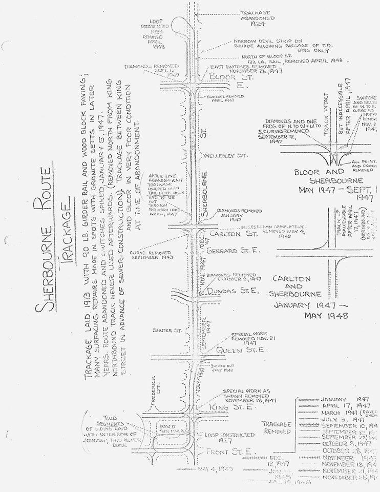
Best of all, we could have the Parliament to Howard route turn left down Sherbourne to reinstate the https://transit.toronto.on.ca/streetcar/4123.shtml

sherbourne-route-trackage-1947.jpg
 
Last edited:
Before trying to resurrect the Parliament streetcar (and bring it to Castle Frank - where it never went, for good practical reasons)
The good practical reason was that service was discontinued when Castle Frank station opened, and replaced with buses.

It certainly went to the corner of Parliament and Bloor for many years. If they were to put a King-like corridor down Parliament, to QQ and George Brown it would move a lot of people of Sherbourne with it's speed, and work well.
 
An alternative alignment could be to go up Parliament to St James St, run it mixed traffic through St James Town (pretty low volume street for cars), then up Sherbourne to Sherbourne Station. You could potentially buy out the church immediately south of the station and build a loop that has a direct underground connection to the subway station, kind of like at St Clair.

It would be somewhat of a less direct route, but cutting right through the heart of St James Town would generate a pretty sizeable amount of traffic. Having lived there for a couple years, even the 5 minute walk to the subway was unpleasant at times.

My thoughts are how is the 506 Carlton car impacted?

If it's ROW operations on Parliament, it may actually be sped up slightly.
 
The good practical reason was that service was discontinued when Castle Frank station opened, and replaced with buses.

It certainly went to the corner of Parliament and Bloor for many years. If they were to put a King-like corridor down Parliament, to QQ and George Brown it would move a lot of people of Sherbourne with it's speed, and work well.
And then the Sherbourne bike lanes could be a safer place. This suggestion has merit. Too bad we don’t work at city hall.
 
My thoughts are how is the 506 Carlton car impacted?
I can't see there being any impact. The most traffic around there is westbound on Gerrard in AM peak. Probably then eastbound on Carlton in PM peak.

Parliament can hand more streetcars there. It's busier south of Dundas.

Ideally though, you'd make the 2 middle lanes cars-only, and put the cars in other 2 lanes.
 
Can anyone answer as to why TTC didn't build an elevator when they added Castle Frank's second entrance? Seemed like the right time.
 
Can anyone answer as to why TTC didn't build an elevator when they added Castle Frank's second entrance? Seemed like the right time.
Presumably because the fire escape was more pressing. And they are two separate structures, without any need to work on together.

Presumably they can just install two elevators from ground surface to platform level in the main entrance about 70 metres from the new second exit structure.

A better question is why can't you get from the bus platform to Bloor Street, through the second exit, or from the bus platform to the to the tracks. It seems unnecessarily restrictive compared to other entrances built in the same program.

Also, could this be connected to the east bayfront LRT and Union Station?
If the Waterfront East LRT is constructed, it would run through Parliament and Queens Quay. So presumably. Might want a loop somewhere though.
 
Sounds like this conversation has gone cold. My interest was sparked by a TOcore Great Streets rendering of Parliament St (from 2018 I think, can't seem to find the report) that shows a streetcar running past St. James Cemetery.

Re: running the Parliament streetcar through a tunnel portal south of Bloor St and to/from Castle Frank on the lower level of the viaduct: I really like the idea of activating unused existing infrastructure. I know it seems prohibitively expensive, but I took a stab at a reconfiguration of the Parliament-Bloor intersection that is, if not cheap, at least conceivable. In the spirit of Vision Zero, I added some other elements to improve pedestrian safety and comfort (no more slip lane, shorter crossings, protected medians, trees to shelter the sidewalk), as well as a queue jump left turn lane for the 94 Wellesley bus, which would get a priority signal. There would ideally be no RTOR for eastbound traffic on Bloor St, to make the crossing safer and to give priority to WB vehicles turning left onto Parliament.

Portal design and dimensions are based on other portals in the city (e.g. QQW and Spadina). Track spacing in the streetcar ROW may not be 100% accurate, but the overall ROW width is more or less correct. Note that a left turn from Parliament NB to Bloor WB is not currently allowed, and that is carried over to this scenario. Also note that I am not a planner or a civil engineer (but would be interested in feedback from anyone in those professions).

Screen Shot 2020-07-05 at 3.26.08 PM.png


While you lose a westbound lane on Bloor in this configuration, you also don't really have to stop westbound traffic except when pedestrians are crossing Bloor.
 
Last edited:
Sounds like this conversation has gone cold. My interest was sparked by a TOcore Great Streets rendering of Parliament St (from 2018 I think, can't seem to find the report) that shows a streetcar running past St. James Cemetery.

Re: running the Parliament streetcar through a tunnel portal south of Bloor St and to/from Castle Frank on the lower level of the viaduct: I really like the idea of activating unused existing infrastructure. I know it seems prohibitively expensive, but I took a stab at a reconfiguration of the Parliament-Bloor intersection that is, if not cheap, at least conceivable. In the spirit of Vision Zero, I added some other elements to improve pedestrian safety and comfort (no more slip lane, shorter crossings, protected medians, trees to shelter the sidewalk), as well as a queue jump left turn lane for the 94 Wellesley bus, which would get a priority signal. There would ideally be no RTOR for eastbound traffic on Bloor St, to make the crossing safer and to give priority to WB vehicles turning left onto Parliament.

Portal design and dimensions are based on other portals in the city (e.g. QQW and Spadina). Track spacing in the streetcar ROW may not be 100% accurate, but the overall ROW width is more or less correct. Note that a left turn from Parliament NB to Bloor WB is not currently allowed, and that is carried over to this scenario. Also note that I am not a planner or a civil engineer (but would be interested in feedback from anyone in those professions).

View attachment 255683

While you lose a westbound lane on Bloor in this configuration, you also don't really have to stop westbound traffic except when pedestrians are crossing Bloor.

After COVID-19, the TTC should be increasing the number of streetcars in its fleet. Doesn't need to be single-ended, but double-ended. No loops, just wye's or crossover tracks to handle the return.
 
[...[
Also note that I am not a planner or a civil engineer (but would be interested in feedback from anyone in those professions).

You're not? Could have fooled me, the drawing is spot-on! In fact I don't see a single drawing or pavement marking error, which is a feat some professional planners and engineers don't even achieve when submitting drawings for review!

My main thought is that the portal should be further south for a couple reasons:
- The subway alignments under the bridge are close to the edges (under the curb lane if I recall correctly). In your picture the northbound track would need to do quite an abrupt turn underground to line up.
- Moving the portal frees up space on the northbound approach of the intersection. This could be used to either shrink the size of the intersection east-west, or to provide a second northbound right turn lane (which would allow the east half of the crossing to get a walk like sooner, giving them a head start westbound while cars are still turning left on the west side).

Also, why did you provide a westbound left-turn bus lane? Wouldn't the bus be replaced by the streetcar? Eliminating that lane would free up space to provide a more substantial buffer on the bike lane along the bridge.

I really like how you provided two-stage crossings for both directions. I realize that multi-stage crossings have a bad wrap in North America due to the hamfisted pedestrian-unfriendly way they tend to be timed, but it is also possible to use them to actually reduce delay for pedestrians (and the intersection overall). In the Netherlands, for example, there are multi-stage crossings everywhere, and they're timed to give a green wave for pedestrians across the various stages. This creates more opportunities for pedestrians to get a Walk signal (like the example I gave above) and also reduces the delay for other traffic (since they only need to wait for pedestrians to cross a couple lanes).
 

Back
Top