Toronto Ontario Line 3 | ?m | ?s

Indeed, two lines are much better for redundancy, and thus for the reliability. The problem in our context is that the 2-nd line will be a lot harder to fund.

First of all, two lines with combined capacity of 50k will cost more than one 40k line times 1.25. Most likely, it will be times 1.7 or 1.8.

And secondly, the optics. Once both the province and the feds invested several billion into Toronto downtown's relief, it will be hard for them to justify starting another multi-billion relief line soon after the first one opens.
Yes, it costs more.
Toronto is nowhere near having a complete rapid transit coverage. If we had relatively good rapid transit coverage and this was roughly the last line we needed, then I agree that we need to build it big.
But we are far from that. No matter what, Yonge will always be the backbone of the system, and the other lines will never need the same capacity. So I say we reduce capacity by 33% and save 20% in costs, and then make another push for "subways" in the 1930's. I thought everyone said the key is to be continually building new transit lines so we don't fall behind.
 
Indeed, two lines are much better for redundancy, and thus for the reliability. The problem in our context is that the 2-nd line will be a lot harder to fund.
This is exactly my concern. It's not by choice I believe "build it big so it doesn't have to be revisited in a generation". It's by necessity. And also the attractiveness of a private investment entity to look at the proposal, realize 'we can build that, but do it even bigger and host RER and VIA HFR too'. Even if it is 'metro' sized, Systra is working with VIA Rail to allow HFR sharing with REM: https://www.systracanada.com/en-pro...e-hfr-via-trains-on-montreal-s-reseau-express. This is done in Europe. (Holland, Belgium, Germany, France etc, etc)
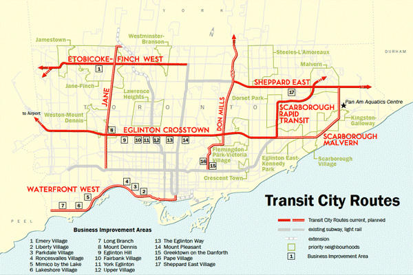
Looking at @Toronto1 's excellent map, I've tried to trace the string that was from, no luck, where can I find more? (Edit to Add: Some here: https://urbantoronto.ca/forum/search/117767/?q=relief+line+north&c[users]=Toronto1&o=date ) What is immediately notable to me besides some interesting choices for routing and bridges, is that all valleys are crossed with bridging, all else is tunnelled. This is worth far more discussion in itself, as if stations are still able to be built within a reasonable budget (deep tunnel *usually* makes for more expensive stations, but not always if done within the tunnel portals) then a more direct routing, and the ability to soften curves to doing it, are enabled by the deep tunnel. It goes under obstructions, far less surface clearing will be necessary, let alone having to follow roads.
But we are far from that. No matter what, Yonge will always be the backbone of the system, and the other lines will never need the same capacity.
I think presuming Yonge remaining the 'spine' of the system for N-S is a mistake. The cost of upgrading the creaking spine to handle the increase is far better spent on alternatives.

For the life of me, and maybe I'm spoiled from time in other nations' capital cities, I can't see why anyone would want to ride on a slow, many stopped subway line when far faster, smoother riding and comfortable modes are available. Relief Line could be that alternative, or at least one of them.

Perhaps once Toronto gets a taste of Private Initiative transport it will realize that the ability of low tax government provision (let alone pathetic leadership the last two generations) is severely limited.

Can I believe the Relief Line can be built and built well within the next decade? Yes...privately. By Gov't? No...take a retroactive look as to how Toronto is now a generation or more behind world cities, and the deficit costs for maintaining what we already have is piling up. That the demand is so acute bodes well for Private Initiative to build. The real worry isn't if we get our worth from such 'private' projects. The question is will our governments make decisions in our best interest when overseeing that? I defer from further comment at this time...
 
Last edited:
If Toronto hadn't been amalgamated Miller wouldn't have had to worry about creating a transit plan that addressed suburban transit needs. Those areas would have their own city council to address such infrastructure concerns.

If transit was based on practical need rather than political want, the DRL would've been built decades ago.

Transit City wasn't perfect, but it addressed Rapid Transit issues in priority neighbourhoods. If it was implemented, there are plenty of areas of the city that would have access to higher order transit right now.

For several decades transit decisions have had as much to do with Queens Park as they have with Toronto.

Miller came after Lastman. Lastman came after amalgamation and after the killing of Network 2011. Network 2011 was...

a541-20111119-network-2011.jpg-resize_then_crop-_frame_bg_color_FFF-h_1365-gravity_center-q_70-preserve_ratio_true-w_2048_.webp

From link.

Which included a Downtown Relief Line, an Eglinton West Subway, a Sheppard Subway, and an extension to the Scarborough Rapid Transit. What Miller wanted to do was to bring rapid transit to the suburban parts of Toronto at a lower cost than heavy rail.

305aef7148c1ab2ab6454b86090c.jpeg

From link. Note that the Don Mills LRT only went down to Line 2 Bloor-Danforth. What was to continue south of Danforth? There were discussions about extending it down to downtown as a light rail versus heavy rail. Until Rob Ford put a stop to that talk.

Interesting that with Doug Ford's Ontario Line, it might not be heavy rail. Could it be light rail, some kind of medium rail, or some "new technology" that is hidden in some glossy brochure somewhere at Queens Park?
 
Transit City was a good plan overall, but omitting the Relief Line was definitely a mistake, and so was low-balling the light rail costs. Remember that when first announced, all 7 lines (SLRT not included) were to cost $6 billion. At the end, the shortened Eglinton line alone costs more than $6 billion.

They should have included the Relief Line, make realistic cost estimates, and perhaps split the pool of proposed lines into Phase 1 and Phase 2 from the onset in order to manage the costs better.
 
^ Good ideas in general. One thing though, Leaside Station isn't being built with a bus terminal so sending the 81 Thorncliffe Park there would mean an on-street transfer. It'd also be wise to retain at least one service connecting Thorncliffe/Flemingdon Parks to the Bloor-Danforth, not everyone will desire transferring onto the new subway for various reasons. So one of the 25/81/100 should continue down there.

In the absence of a Mortimer Station minding the gap between the Danforth and Gamble, surface transit ought to retained on Pape Ave; so ergo the 81 suits all these needs fittingly and could terminate at Science Centre Station on the north end, paralleling the Ontario Line.
 
Never mind that the Canada Line is far from exemplifying quality infrastructure. The project was built quickly and cheaply, and it shows. The 10 year old line is woefully underbuilt, and already hitting its capacity limits. Similar story with REM in Montreal, and the same thing will happen with Ontario Line too.

The whole Canada Line thing is a bit of misinformation that you and others on this forum keep purporting, and a simple google search would completely prove you wrong.


The RFP also required that the system have a capacity of 15,000 passengers per hour in each direction (leaving the choice of technology and platform length to the proponent)

The fleet consists of 20 fully automated two-car articulated trains, for a total of 40 cars. The capacity of the trains is estimated at 334 people per pair of cars (comfortably) or 400 people at crush load.

As of late 2017, Translink has ordered another 24 trains, sole sourced from Hyundai Rotem

This will increase the Canada Line’s capacity from the existing 6,100 passengers per hour per direction (pphpd) to over 8,000 pphpd.
With further orders of trains beyond the order in 20, the frequency will be increased even further to one train every two minutes, providing a capacity of 10,000 pphpd, over the next 20 years.

And here is the part that ALWAYS gets left out here:


An ultimate system design capacity of 15,000 pphpd can be achieved when all station platform lengths are extended from 40 metres to 50 metres to accommodate a three-car-long train.

The platform lengths were built to be extended by 10 metres (the underground stations already are 50 meters) thus the system capacity will almost double, something thats not foreseen for quite a long time.
 
Here is the "G1 map" with potential bus routes:
Excellent to see you including the all-important 'connections' by bus and if they ran there, streetcar/LRT. What seems to get lost in the discussion for many is that a station can't and won't be built at the end of every block. That's especially the case with deep tunnel systems, and people must realize that taking surface transport to the nearest station is something that most Torontonians have to do. If one lives close to a station, wonderful, walking distance is your oyster, but emphasis must be placed on stations that serve as hubs, and far enough apart to allow higher speed line travel, and to save on the costs of those stations. It's the stations that are the greatest expense on deep tunnelled systems, not the tunnelling itself.

I could only find a few of your prior posts, please post more maps here if you can, or at least link to pages where you have. A map is worth a thousand plus (with inflation added) words.
 
Last edited:
If the RT is still in service when the Relief Line opens it may not be called Line 3 or the colour blue.
Trust me, the relief line will be nowhere near construction by the time the scarborough line ("rt") is withdrawn due to the poor design, hard to maintain infrastructure. It's now just a 35 year old derelict.

^ Good ideas in general. One thing though, Leaside Station isn't being built with a bus terminal
I think you meant to refer to is Laird Stn, not Leaside Stn (Bayview).

I made a map of what the optimal routing could be. Sorry the map is pretty pixelated.
The station is at the west corner because of the optimal connections and metrolinx recommended it for DRL North

-81 now runs mostly in the Thorncliffe loop connecting to the station and B branch goes to Pape stn (recommended by Hopkins123) and A branch goes to Flemingdon Park Stn.
-88 Stays the same but with street connection to Thorncliffe Stn
-100 starts at Thorncliffe Stn to flemingdon park so the route south of don river is eliminated
-51 (Leslie) will run from Donlands Station to Steeles via Laird Stn as proposed by the board shown here
182293
 
So the single bore configuration has the trains on different level platforms then. Maybe they’ll make an exception for the underground interchange stations.
 
So the single bore configuration has the trains on different level platforms then. Maybe they’ll make an exception for the underground interchange stations.

Yeah, single bore is a cheap (depending on soil conditions) way of building low/mid volume stations. An interchange location would look more like what we do today.
 
Maybe they could integrate it like this elevated in high density areas, including downtown.


27626762267_588d21f5a2_h.jpg
Elevated Transit? In my City? Oh no the horror!!! What about muh sight lines, muh property values, won't somebody please think of the home owners!!! What about the wheather?????? Didn't you know Toronto is the only place on earth that experiences winter?
 
rsz_gettyimages-487975535.jpg


I dont get why people hate elevated so much.....if you can in this pic the towers are the ones causing the shadows. If done properly they can make it look good and pleasing to the eye...but then again...
done properly is rarely a known term in canadian infrastructure building and the issue of nimbys. I bet most of them dont even take transit

182326


Another pic for reference on how to do it right
 

Back
Top