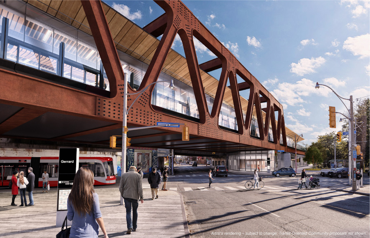
Toronto East Harbour Transit Hub | 14.35m | 1s | Metrolinx | Metrolinx

interchange42

Administrator
Staff member
Member Bio
Joined
Apr 23, 2007
Messages
27,167
Reaction score
35,408
Location
by the Humber
We have a pile of old renderings in the regular East Harbour thread of early concepts for the transit station here. Today, all of the other Ontario Line stations had renderings released, but not for this one…

…but it's likely time to start a thread (and soon a database file) for this station, and I'll kick it off with this neighbourhood context map for the Ontario Line station;

EastHarbourStnAreaMap.jpg


42
 
Too bad there's not exit on Cherry St in the photo up above ! Which will be needed in the future to funnel Toronto pedestrians into Villiers Island and harbourfront area etc.
 
Too bad there's not exit on Cherry St in the photo up above ! Which will be needed in the future to funnel Toronto pedestrians into Villiers Island and harbourfront area etc.
Agreed, the big miss of this entire project is a cherry street station, especially as the 504 gets extended into the portlands, it would really be a great connection point to commuters heading west from the port lands.
 
Agreed, the big miss of this entire project is a cherry street station, especially as the 504 gets extended into the portlands, it would really be a great connection point to commuters heading west from the port lands.
If they can level off the rail incline below Cherry St to create a future stop. Then continue to descend to the next stop. Would secure a position for a future subway stop below Cherry St.
 
Is it me, or when stitching all those wonderful maps that Mr. 42 has provided in my head (may not be advisable) the proposed line seems to meander around like drunken sailor in a frigate on rough seas...or a winding back road through the Rockies? And if so, is there a rhyme and reason for this?

...while I can appreciate this line can't go as the crow flies, but the crazy direction changing I've been seeing is rather surprising...to put it mildly.
yup, like instead of the RLS going straight across, we saved money and used the go tracks to cross the river, then it has to go up to queen, then back down to exhibition.
Thats the reasoning behind why it does that

exhibition is still skeptical on, the Thorncliffe park not having the trains run evevated above the road is also not ideal.
 
And a better idea of what this will look like all together is shown here:

 
We have a pile of old renderings in the regular East Harbour thread of early concepts for the transit station here. Today, all of the other Ontario Line stations had renderings released, but not for this one…

…but it's likely time to start a thread (and soon a database file) for this station, and I'll kick it off with this neighbourhood context map for the Ontario Line station;

olta_east_segment_maps_mx_engage_east_harbour_20220202_final.png


42
What’s with the tunnel portal? I thought it’s above ground and in the rail berm until it gets close to parliament, THEN tunnel
 
Is it me, or when stitching all those wonderful maps that Mr. 42 has provided in my head (may not be advisable) the proposed line seems to meander around like drunken sailor in a frigate on rough seas...or a winding back road through the Rockies? And if so, is there a rhyme and reason for this?

...while I can appreciate this line can't go as the crow flies, but the crazy direction changing I've been seeing is rather surprising...to put it mildly.

There are some key concepts here; the idea is not a new one; that a single line should serve a series of key targets, not merely follow a straight-line.

So, what you see a product of several goals.

1) Relieve Line 1 (Yonge portion) by creating a new route between Line 2 and downtown (which specifically relieves the Bloor-Yonge interchange).

2) Then you see a specific goal x 2 at the extreme west, one is to serve the CNE/Ontario Place, the other is to serve Liberty Village.

3) You do see a goal to have costs by corridor-sharing w/GO

4) There is a clear notion than a E-W line through downtown ought not to pass too close to Union as that would be redundant.
The issue is not merely one of conveniencing more riders, it's one of not overloading the local sidewalks/path network and serving a greater range of destinations.

5) There is a desire to maximize possible gains in density and hit other key nodes (Distillery District as example)
I don't want to overstate the link to the O/L here, as the Relief line did something quite similar, just with a smoother underground trajectory near the crossing of the Don River due to depth
That, of course, somewhat increased costs and produced other trade-offs vs the current concept.

There was no R-L contemplated west of University so we really can't say what that would have looked like, but a south-west trajectory was definitely discussed previously in order to hit that Liberty Village density and relieve
King car in particular.
 
What’s with the tunnel portal? I thought it’s above ground and in the rail berm until it gets close to parliament, THEN tunnel
Well… no.

It's pretty deep at Corktown station, and gradually rises as it travels under the south end of the Distillery District and under Cherry Street and then to the surface at the west end of Corktown Common's southern edge, continuing to climb once its outdoors to get over the Don to the elevated East Harbour station. It's essentially redundant for me to write all that, it's just surfacing farther east than you thought, that's all. Gentler grades that way, and it takes up less surface space.

42
I've seen the cross section at the Corktown station. And ask why does the subway line have to sink down that low at that level real fast. When there's nothing above it but parking and one storey warehouse buildings having no basement obstructing the path. That's will be torn down anyway for future development. Which could make it possible to put a leveled stop below or above at Cherry st in the future. Which I strongly feel this stop will be used tremendously in the future with the locals and tourists. Exiting off to Villiers Island and the harbourfront etc by transferring on the Cherry st LRT to get there! JUST A THOUGHT!
 
I've seen the cross section at the Corktown station. And ask why does the subway line have to sink down that low at that level real fast.
Tunnelling through bedrock - there's plenty of stuff underground across the city (sewers, water, hydro, gas, Enwave and other utilities) as well as various building foundations.
It's easier to just go completely underneath all of it - especially when the Ontario line tunnel isn't wholly in a road ROW and the route wasn't protected from incursion from building foundations for decades etc.
 
It remains to be seen whether the Broadview Avenue extension will actually have streetcar trackage on Day 1 - the 30 March Executive Committee states
[City and Cadillac Fairview will each fund 50% of the cost] for the road portion of the Broadview Avenue extension from Eastern Avenue to the Metrolinx rail embankment.
The cost for this segment of the Broadview Avenue Extension is estimated at $9.0 million based on schematic design (i.e. 10% design). A streetcar in the centre of the Right of Way will be protected for and implemented when the service is needed. Funding for this streetcar portion will be secured in a future budget cycle.
(EA thread)
 
Tunnelling through bedrock - there's plenty of stuff underground across the city (sewers, water, hydro, gas, Enwave and other utilities) as well as various building foundations.
It's easier to just go completely underneath all of it - especially when the Ontario line tunnel isn't wholly in a road ROW and the route wasn't protected from incursion from building foundations for decades etc.
I gather from where you live this would be known as a "deep tube".
 

Back
Top