Bingo, and the current bridge is slated to be torn down and replaced itself. Two parallel bridges will carry six lanes of traffic, a couple of years from now.
Boy, a lot's changed since I started this thread. The 4-lane bridge over Sixteen Mile Creek is gone gone gone. The first span opened some time ago and the second is about to, if it hasn't opened already.
I found a couple of interesting shots about the area from the Halton archives.
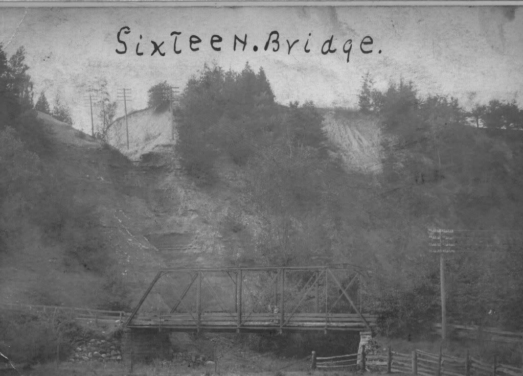
This bridge was the first "reliable" bridge built to carry Dundas Street -- Hwy 5 -- across Sixteen Mile Creek down in Proudfoot's Hollow. Here's the citation that accompanies it...
This photograph of "the metal 88-foot (26.8 m) bridge built in 1885 was the first dependable bridge to carry Dundas Street over Sixteen Mile Creek but came too late for the villagers. It served well until the first concrete high-level bridge spanned the ravine in 1921, an engineering marvel which people came from miles around to see. The old tortuous road was finally closed in 1922. In 1960 the 1921 bridge was in its turn superseded by the present four-lane bridge, but the piers of the earlier bridge remain. Now in 2008, the bridge is again undergoing reconstruction with new piers built on the same line as 1921. Taken from "Sixteen Hollow - 1820-1880: by Judith Bourke, link provided in this record. Ms. Bourke also says, "The journey to the village at the foot of the steeply sloping sides of the ravine was notoriously dangerous."
Note the two women standing on the bridge. Their long dresses and the power lines indicate this photograph may have been taken around 1920.
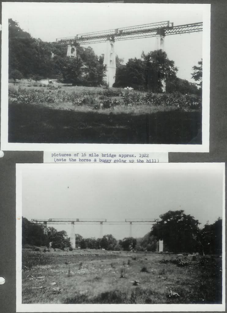
And here's the bridge that replaced it, under construction, about 1921-1922 or so. Citation follows.
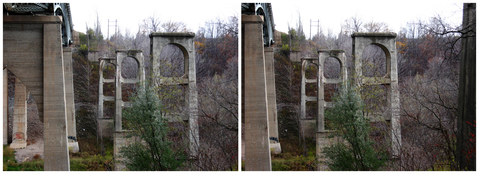
The following observations have been suggested by these photographs: It appears that they were rolling the bridge trusses out from the west bank, onto the concrete piers, and that they were building the piers one at a time, possibly filling the formwork with concrete from the top. This would make sense, because cart loads of concrete could be brought from the west bank, where it was being mixed, over to the top of the pier under construction, and then poured down, (not lifted up as we do today). Why? Cranes were simply not available as they are today, so it was much easier to move heavy loads of material from above and let gravity do the rest. Also, these trusses in the photos appear to be of an older type, the so-called lattice truss type. [Could these be] the older trusses from the Anson Buck iron bridge? If so, it would suggest that the lower parts of the piers were actually stone, and that the bridge was not rebuilt, but added to. The photos are suggesting that the difficulty of going halfway down a steep hill to get to the bridge and then back up the other side, was the reason why the bridge was raised to the top of the valley, and, that the frugal bridge builders simply took the old iron trusses off the foundations, added concrete piers on top ot the original stone piers until they reached the elevation of the top of the valley, and then replaced the iron trusses on top of these piers.
You will notice in the lower picture that the bridge does not (yet) continue to the right of the tall trees, and that there appears to be board formwork where the next pier should be. Also the trusses on top of the bridge trusses are offset from the piers, indicating that they are being moved out onto the bridge from the left bank.
Note the horse and buggy going up the hill in the top picture, and it's hard to see, but possibly two people with a car to the right.
These steep valley hillside roads were sometimes referred to by local people as "hogback" roads.
Date of Publication:
1922
Nope, they utterly removed the 1960 bridge. It's where the new span is now. Even the 1921 bridge has had four of its six piers removed, though they stood like dominoes for nearly 50 years.
Thanks! Though I imagine that those ones there, at Bronte Creek, are for the chop themselves. When they rebuild the Dundas Street bridge there and expand it to six lanes, they're probably going to want to recover the 1921 course there for the westbound span. So photograph them while you can!
...I imagine that those ones there, at Bronte Creek, are for the chop themselves. When they rebuild the Dundas Street bridge there and expand it to six lanes, they're probably going to want to recover the 1921 course there for the westbound span. So photograph them while you can!
Boy, did I call THAT one wrong. They built a bridge across it in the style of the one that was there in the 1920s, using those abutments, and ran a huge pipeline across it. I should dig out the photos.


") The 4-lane bridge over Sixteen Mile Creek is gone gone gone. The first span opened some time ago and the second is about to, if it hasn't opened already.
The 4-lane bridge over Sixteen Mile Creek is gone gone gone. The first span opened some time ago and the second is about to, if it hasn't opened already.