News   Apr 24, 2024
 280     0 
News   Apr 24, 2024
 493     0 
News   Apr 24, 2024
 481     0 

Lost Bridge: 4th Line at Sixteen Mile Creek

Looking at the border between Oakville and Mississauga, it looks like Upper Middle Road and the QEW are actually the same concession road?
Correct on that one. Also explains the presence of the N/S Service Road/Sheridan Way; it's the ghost of the old Middle Road. (And likewise, the Lakeshore/Royal Windsor/QEW continuum = yet another concession, and yet another service-road pair. Ditto w/the QEW from Stoney Creek to St Kitts.)

And why does Eglinton become "Lower Base Line"?
Because it hasn't gotten the chance to be renamed "Eglinton" yet. (Come to think of it, I believe Eglinton in Mississauga was called "Base Line" well into the 1960s; I don't know when it became Eglinton, perhaps c1970 when Eglinton leapt the Humber and swallowed Richview, and onward through the redesigned 401/427 interchange into Mississauga...)
 
I wonder if Oakville plans to rename Lower Base Line to Eglinton. I mean, Lower Base Line isn't much of a name.
 
Wrong river!

I also realized today it's Twelve Mile Creek, not Sixteen. D'oh! :D
 
I also realized today it's Twelve Mile Creek, not Sixteen. D'oh! :D

They ought to rename them to metric names. So Twelve Mile Creek should be renamed 19 Kilometre Creek (or 19.3 if you want to get anal).

Sixteen Mile Creek should be 26 Kilometre Creek (or 25.75).

Are those both creeks, cuz I could have sworn I've heard of Sixteen Mile Creek as well. But I'm not Oakvillian so I could be wrong.
 
Are those both creeks, cuz I could have sworn I've heard of Sixteen Mile Creek as well. But I'm not Oakvillian so I could be wrong.

Yeah, there's two of them... I just mixed them up. :)

Anyone happen to know twelve miles/sixteen miles from WHAT?
 
Here's a reply on that object near the creek ...

Sorry for the long delay in responding to your email. The abutment you saw is the remains of a bridge which crossed the 16 Mile Creek at Glen Orchy before the current Bailey Bridge. Obviously it was at a higher level. The long-time Oakville residents I spoke with couldn't recall when it was taken down but I understand that the Town Planning Department has a file on it. You could contact the Town's Heritage Planner, Zubeda Poonja, at zpoonja@oakville.ca

George Chisholm, UE
President
Oakville Historical Society
 
So that's what it was! I wondered where and how it connected to 4th Line on the south side. It must have been gone a long time; there's no hint of whatever used to be on that side.
 
Why was Fourth Line broken up and cut off? Why couldn't they just keep the whole thing together?

It's been superseded by Nayagawa Blvd., the way down to the tiny one-lane bridge is treacherous in winter and was closed about half the year even when the route was still officially open, and 4th Line has been bisected by the 407 immediately south of the river.
 
Ah, excellent.

Reminds me when I was there checking the place out.

The remains of this structure had me puzzled as well. It's one of those mysteries that I'm sure one of us will solve within the next few weeks. But I'd be very interested in knowing what this structure's purpose was. To me it looks like the old remains of a bridge, or mill.

There were no markings on the structure as to what could it be?


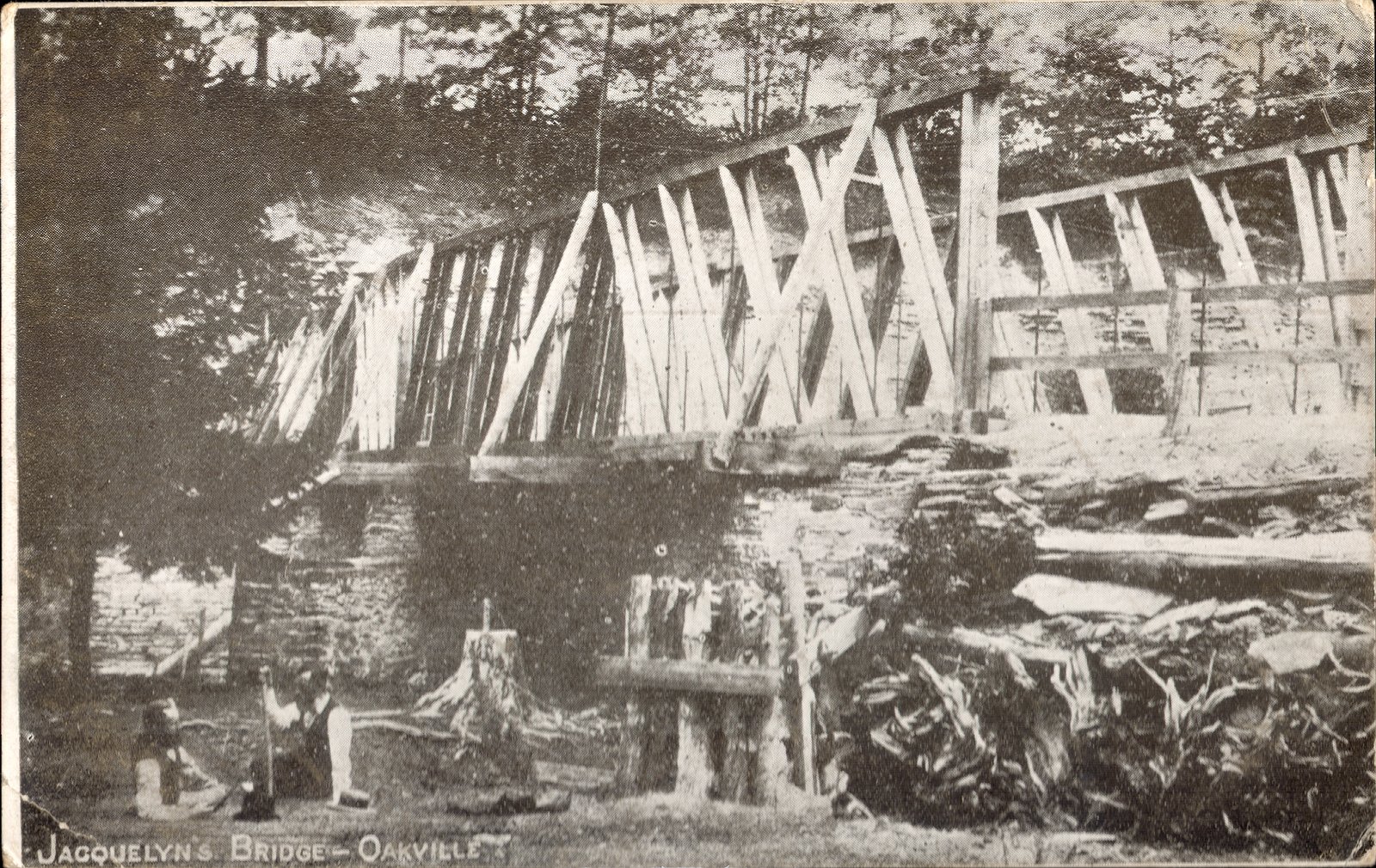
I found this the other day on Halton's archive site. I don't know for sure but I'm strongly inclined to believe that this is the bridge that was carried by that stone structure, in a photograph just about a hundred years ago...

Jacquelyn's Bridge... Back of postcard reads- "One of the old time bridges outside Oakville Town. These are fast disappearing to make room for new ones suited to automobile traffic."

TTHS074047f.jpg
 
I wonder if Oakville plans to rename Lower Base Line to Eglinton. I mean, Lower Base Line isn't much of a name.

The Mississuaga-Milton boundary shifted west a couple of years ago as the strip of land between the 407 and Ninth Line was transferred from Milton to Mississauga, and then just last year the section of Lower Base Line east of the 407 was changed to Eglinton, making Eglinton just a little bit longer.
 
The Mississuaga-Milton boundary shifted west a couple of years ago as the strip of land between the 407 and Ninth Line was transferred from Milton to Mississauga, and then just last year the section of Lower Base Line east of the 407 was changed to Eglinton, making Eglinton just a little bit longer.

The province transferred a parcel of land (bounded by Ninth Line, Winston Churchill Blvd., Dundas Street, and the 401) from Halton to Peel on Jan. 1, 1974, when these two counties were created as regional municipalities. This was partly to compensate the contemporaneously-created City of Mississauga for the land the former Town of Mississauga was losing to the new City of Brampton (everything between Steeles Avenue and the hydro corridor to the south... transferring, for instance, Churchville from Mississauga to Brampton). If I'm not mistaken, what's now called Eglinton Avenue in Peel was then still called Base Line Road, and it was renamed, sometime in the 1970s, Eglinton Avenue in keeping with the Metro road it connected to. The towns of Streetsville and Port Credit were amalgamated into the City of Mississauga on the same day.

The stretch of the road west of Ninth Line was, and remains, called Lower Base Line Road, to differentiate it from Upper Base Line Road--which, ironically, is south of Lower Base Line Road, and would be the course of the QEW if it didn't turn southward in the vicinity of Ninth Line (where the Ford plant is).
 
Why did Mississauga lose the land between the 407 and Steeles anyway? I always wondered why our northern border wasn't Steeles like Toronto's.
 
The province transferred a parcel of land (bounded by Ninth Line, Winston Churchill Blvd., Dundas Street, and the 401) from Halton to Peel on Jan. 1, 1974, when these two counties were created as regional municipalities. This was partly to compensate the contemporaneously-created City of Mississauga for the land the former Town of Mississauga was losing to the new City of Brampton (everything between Steeles Avenue and the hydro corridor to the south... transferring, for instance, Churchville from Mississauga to Brampton). If I'm not mistaken, what's now called Eglinton Avenue in Peel was then still called Base Line Road, and it was renamed, sometime in the 1970s, Eglinton Avenue in keeping with the Metro road it connected to. The towns of Streetsville and Port Credit were amalgamated into the City of Mississauga on the same day.

The stretch of the road west of Ninth Line was, and remains, called Lower Base Line Road, to differentiate it from Upper Base Line Road--which, ironically, is south of Lower Base Line Road, and would be the course of the QEW if it didn't turn southward in the vicinity of Ninth Line (where the Ford plant is).


Those types of road names come from the old survey system in Ontario.
Lower Base Line Road was probably given that name because it was the line at which at which the lot numbers in north Trafalgar township started. You can see it on the old county atlas maps.
http://digital.library.mcgill.ca/countyatlas/SearchMapframes.php

In south Trafalgar township, lots were numbered 1 to 35 from east to west, while the Concession numbers ran north & south of Dundas St (the 'old survey'?). In north Trafalgar township the lots were numbered 1 to 15 going north from the Lower Base Line, while the Concessions ran west to east.

Old Toronto Township/Mississauga was surveyed the same way - so that would explain why Eglinton was also a Base Line Road.

I thought the QEW followed the course of 'Middle Road' - at least in Oakville.
 

Back
Top