News   Apr 17, 2024
 447     0 
News   Apr 17, 2024
 297     0 
News   Apr 17, 2024
 1.8K     1 

Large blocks of properties up for Heritage designation

Northern Light

Superstar
Member Bio
Joined
May 20, 2007
Messages
31,671
Reaction score
88,626
Location
Toronto/EY
Thought I'd start a dedicated thread of this as vast numbers of properties are up for designation at the Nov 30th Meeting of the Preservation Board.

The overall meeting agenda can be found here: http://app.toronto.ca/tmmis/decisio...n=doPrepare&meetingId=18140#Meeting-2020.PB19

I'll add links and addresses over several posts.

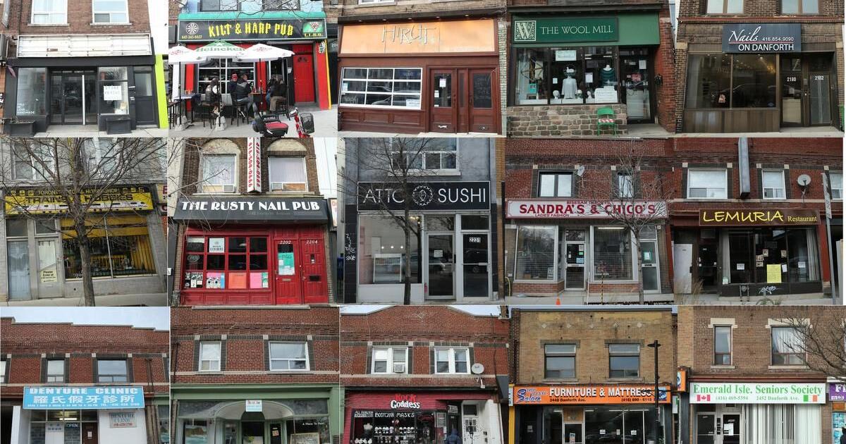
But here is the report for a block of properties fronting Danforth from Coxwell to Victoria Park; and on Dawes Road:


I am not documenting 10 Dawes as we have a dedicated thread for that; but all the other designations on Dawes are shown below.

I will get to others later:

Below is one one of the blocks of properties from Dawes Road, homes at 72-82 Dawes Road: (all photos from Streetview)

1605908383361.png


These are 90-94 Dawes:

1605908644239.png


This is 104 Dawes:

1605908742645.png
 
15 Chisolm is also noted for designation in the report linked in the post above:

That's the Masonic Temple that is the subject of a redevelopment application already.

The thread for which is here: https://urbantoronto.ca/forum/threads/15-chisholm-m-6s-katalyst-bnkc.30408/

All photos in this post are Streetview:

1605909219094.png


699 Coxwell:

1605909424206.png


1586 Danforth is CIBC branch here:

1605909618758.png


This entire block is up from 1590-1606:

1605909816202.png


1686-1708 is this block, all:

1605910084823.png


1779-1781:


1605910196478.png


1784-1794 is this block:

1605910313872.png


This is 1799 Danforth:

1605910396091.png


1800-1802:

1605910494140.png


1810-1814:

1605910601311.png


1820-1846:

1605910811478.png


This entire strip, 1839-1863:

1605911085666.png
 

Attachments

  • 1605909906594.png
    1605909906594.png
    474.8 KB · Views: 249
  • 1605909978126.png
    1605909978126.png
    319.7 KB · Views: 241
Post above continued; all photos streetview:

1852-1858:

1605911298133.png


1870-1878:

1605911571974.png


1902-1914:

1605911656452.png


1928-1954: (this is from Sebs, all the way to the corner and the Pizza Nova:

1605911863894.png


This entire row: 1956-2050

1605912238420.png


2056-2064 (sigh, that only gets us to Woodbine!)

1605912331082.png


You may note that the Dollarama was once a Kresge; the forerunner of K-Mart.
 
I like the idea of saving several of these, and catching up on stuff that should have been designated, by most people's standards, years ago.

On the other hand, while there are a few gems in here, there are also a bunch of also-rans; and stuff that in near-original condition is just, well, dull.

Not to mention several EIFS covered facades that may or may not be able to be redeemed.

This appears to be an attempt at a Heritage Conservation District by any other name; but one that isn't nearly as easy to appeal.
 
I wish we could sticky this thread...as it could become a very useful reference to us UT'ers when it comes to heritage designations for our city.
 
Is this a result of the province pushing for more density near subway stations? As mentioned above, some of these properties seem to be of dubious historic value. Is this just another means for Toronto to push back on urbanizing the Danforth?
 
Is this a result of the province pushing for more density near subway stations? As mentioned above, some of these properties seem to be of dubious historic value. Is this just another means for Toronto to push back on urbanizing the Danforth?

In the case of the Danforth properties; I'm really not sure.

The Councillor here is Bradford, and he's a former professional planner, who is generally pro-cycling, pro-transit and pro-density.

Also many of these properties would be comparatively difficult to develop in that they are only ~30M deep; it can be done, and is at 2 different lots on the Danforth, but it typically requires a fair sized frontage/assembly; and a deft hand at navigating the neighbours and Councillor; not only to comply w/planning policies, but just to work out a viable construction plan.

I'd be interested to know the motivation myself.
 
In reference to this this image, from the above series:

1605985975060.png


I found this picture from 1967 on Steve Munro's site here: https://swanboatsteve.files.wordpress.com/2011/12/img395cb.jpg
1605985781714.png


It shows the Kresge store, as noted, and beside it, in what is now the Royal Bank, a Woolworth's. (that was the forerunner of Woolco, which would be bought out to become beginning of Walmart Canada).
 
Last edited:
The Star is now on this story:


They did the math, the bulk listings and designations would add 966 properties to the Register.
 
Not sure I agree, if you want to know what's listed or designated just use the official Heritage Register! https://www.toronto.ca/city-government/planning-development/heritage-preservation/heritage-register/
I get that it be difficult to maintain and update, but I standby that this would be a useful thread using different sources...as one of the questions I've seen mostly asked is the heritage status of a site that doesn't contain just a surface parking on it. I think the key here is making it informal and non-comprehensive with links, as you have done, to more formal, updated 3rd party sites.
 
The Royal Bank building is a great sample of ,what I thought, was 70’s. I’m pleasantly surprised that this was already here in ‘67. In retrospect Habitat was built for Expo 67 so this was also ahead of or perhaps a great example of it’s time. I believe it’s empty now? I hope it doesn’t stay that way.
 
The Star is now on this story:


They did the math, the bulk listings and designations would add 966 properties to the Register.
 

Back
Top