News   Apr 23, 2024
 287     0 
News   Apr 23, 2024
 871     0 
News   Apr 23, 2024
 487     0 

Green Line Parks System - Midtown Toronto

Northern Light

Superstar
Member Bio
Joined
May 20, 2007
Messages
31,826
Reaction score
89,103
Location
Toronto/EY
I was sure we had a thread for this somewhere.............

But maybe my memory is playing tricks on me.............

At any rate.

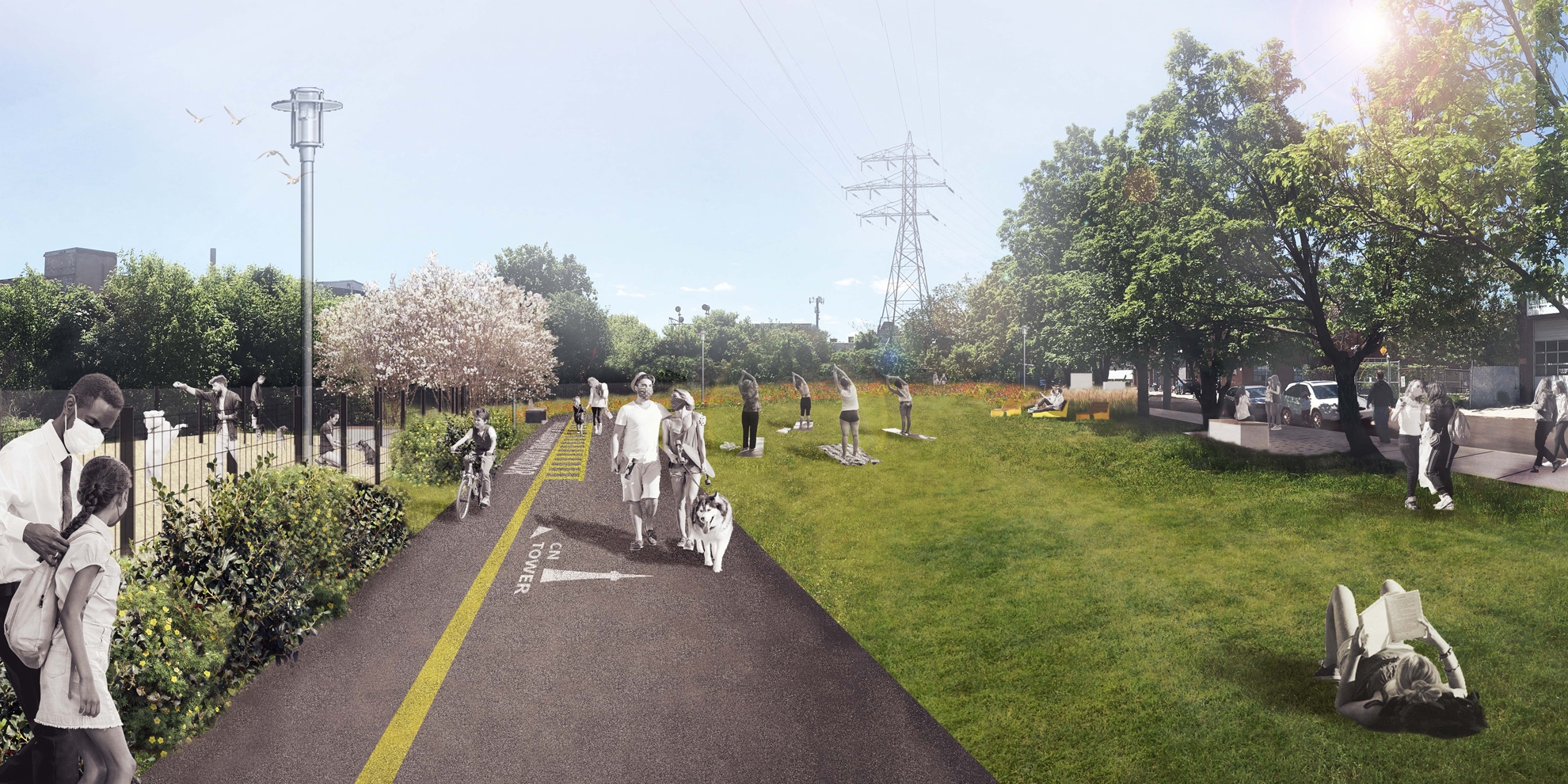
The City is working towards a complete walking/cycling path across midtown, mostly along the CP rail corridor from Yonge Street to points west, but eventually run north-west following some hydro towers.

This project has been tagged the Green Line.

The first of these are off and running with an enhancement of and expansion to Geary Avenue Park.

Renders from DTAH are here:
1594130654743.png


1594130722147.png


1594130861798.png

 
Last edited:
I think that this Green Line could be the next "Toronto Railpath" aka bikeway if its connected to a larger system.

2016 bikeways plan.png


Ive added in blue to the 2016 bikeway plan the Green line, and other approved lines like the Davenport Diamond path being built along with the grade separation project for Metrolinx.

In red are my suggestions to connect them into a larger nextwork of bikeways. Purple is existing, dotted purple is planned, and orange are cycle tracks either planned or because there isnt sufficient room for a multi use trail
 

Attachments

  • 2016 bikeways plan.png
    2016 bikeways plan.png
    959 KB · Views: 303
Last edited:
Upcoming public meeting for the Geary Ave Park expansion available online:


Event Information: Geary Avenue Park Expansion - Public Meeting #2

Date and time:Wednesday, November 4, 2020 6:30 pm
Eastern Standard Time (Toronto, GMT-05:00)
Change time zone
Duration:1 hour 30 minutes
 
I recently moved "up north" closer to the Green Line, so I'm paying a bit more attention to it now. :)

One connection missing from @robmausser's map is that the Green Line could easily continue further north-west along the hydro corridor through S.A.D.R.A. Park. Already pathways through there, just need some better road crossings and a few other connections.

Also, with upcoming road reconfigurations around St. Clair and Old Weston, there's the possibility of connecting SADRA Park to the lavender Creek Trail via the Turnberry/Gunns railway crossing.

There's so much opportunity with just filling in all these little gaps along the way.
 

Geary Avenue Park Expansion Virtual Public Meeting

A virtual open house and public meeting for Geary Avenue Park Expansion will be held on November 4, 2020, from 6:30-8PM. This project will be one of the first new parks in the Green Line. At the virtual meeting we will provide project updates and present a preferred concept plan, which was informed by the feedback collected in July 2020. Learn more here

Following the successful completion of the Green Line Implementation Plan, DTAH has been selected by the City of Toronto to lead the implementation of the Green Line, including Geary Avenue and Macpherson Avenue Parks. The Geary Avenue Park Expansion will transform a segment of the hydro corridor running parallel to Geary Avenue between Delaware Avenue and Westmoreland Avenue into new park space. Streetscape improvements will link the expanded Geary Avenue Park to the existing Bartlett Parkette at Salem Avenue.

Perspective_West-Park-DOLA_WEB.jpg
 
I cant help but be disapointed by this; I thought there would be a linear multi-use path throughout the 5km.
 
Presentation doc is up here: https://www.toronto.ca/wp-content/u...expansion-meeting-presentation-nov-4-2020.pdf

Online questionnaire up until Nov 22: https://s.cotsurvey.chkmkt.com/?e=212697&h=3F3B083BDD735B4&l=en

Some main pieces of contention from the meeting yesterday were the dog park size/configuration and connections between the parks/to adjacent streets.

Glad to see everyone masked up in the renderings :)

View attachment 280913

View attachment 280912

View attachment 280909

View attachment 280911

View attachment 280910

View attachment 280908

View attachment 280907

View attachment 280906

What's the point of these nowhere paths? Why isn't there a ramped overpass over Dovercourt Road? This is really disappointing.
 
I understand that budget limitations may preclude construction of a bridge over Dovercourt at this point. But why build the dog run right up against the rail corridor? That would be the natural place to connect a future multi-use path, but the entire park will now have to be reconfigured if there's a future opportunity to build a bridge over Dovercourt.
 
What's the point of these nowhere paths? Why isn't there a ramped overpass over Dovercourt Road? This is really disappointing.

These same concerns were brought up in the meeting. Their reasoning for lack of a bridge connection between the parks was because Hydro One expressed concerns with lack of height available below their lines.

Personally I don't see why a multiuse trail/bridge couldn't be tucked up against the rail corridor... seems to be plenty of height available there.
 
Another qualm I had was with the "green line" marking their using on all the pathways.

They expressed that the pathways are not being designed to be used for cycling and that this is simply an aesthetic choice, but I could see these markings being confused with multi-use trail markings. Maybe shifting it closer to one side would help.

Also not a huge fan of the clip-arty graphics they're currently planning to put on the pathways (hopefully just placeholders?).

1604604941257.png
 
These same concerns were brought up in the meeting. Their reasoning for lack of a bridge connection between the parks was because Hydro One expressed concerns with lack of height available below their lines.

Personally I don't see why a multiuse trail/bridge couldn't be tucked up against the rail corridor... seems to be plenty of height available there.

Even without a bridge they could have the trails come to the intersection with an intersectional bike crossing with bike lights etc.
 

Back
Top