


BurlOak
Senior Member
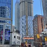
Interesting that 2 exterior girders are floating in space. Maybe using the same technology, they could eliminate all the piers.
|
|
|
Interesting that 2 exterior girders are floating in space. Maybe using the same technology, they could eliminate all the piers.
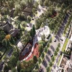
Just read the report that AoD posted about the linear park proposed along the new Gardiner. I think it is misguided to think that people will dwell in this linear park along a very noisy and active highway (Lake Shore below, Gardiner above). The renderings (below) depict a lush place where moms will push strollers, kids will hang out on rocks, and everybody will pretend they're hanging out at waters edge. Just because the shoreline was once here doesn't mean we should pay homage with this green and rocky outdoor shoreline along the highway. At heart here in my view is a moral discomfort with any new high capacity autocentric infrastructure, so it must be tamed with grandiose naturalizing of that space even if that doesn't work well for an highly urbanized pedestrian corridor. Maybe that is just how it is presented for public consumption, but I don't think it will work as depicted. It would be better to treat it like the infrastructure it needs to be, and invest perhaps no more money in separating the cars from people on bikes and on foot, using a glass wall. Something like exists under the rail corridor along Bay could be a decent model (pictured). Buildings could be built right along this enclosed corridor, and residents could step out into bike- and pedestrian-friendly corridor. Developers could help build this corridor if they were allowed to build a bit closer to the Gardiner. This would be a more appropriate urbanized vision for multi-modal mobility.
Not sure if there's all that much room for development built right up against the Gardiner. It would certainly help hide the structure, but not sure how viable it is. However I definitely welcome the naturalization along the East Gardiner. Believe it or not, but there are people that are willing to bike along any trails. Perhaps not families and amblers, but pedal commuters would use it - particularly those that don't want to deal with the slower pace of the QQ trail. And if the alternative to a path and tree plantings is mud, gravel, hobo encampments, I think many would prefer the former vs latter. Even as a driver it's nice to see greenery. When passing by Fort York on the Gardiner you can see tree tops. And Lake Shore is way too dark and dank. This will be welcome.
Just read the report that AoD posted about the linear park proposed along the new Gardiner. I think it is misguided to think that people will dwell in this linear park along a very noisy and active highway (Lake Shore below, Gardiner above). The renderings (below) depict a lush place where moms will push strollers, kids will hang out on rocks, and everybody will pretend they're hanging out at waters edge. Just because the shoreline was once here doesn't mean we should pay homage with this green and rocky outdoor shoreline along the highway. At heart here in my view is a moral discomfort with any new high capacity autocentric infrastructure, so it must be tamed with grandiose naturalizing of that space even if that doesn't work well for an highly urbanized pedestrian corridor. Maybe that is just how it is presented for public consumption, but I don't think it will work as depicted. It would be better to treat it like the infrastructure it needs to be, and invest perhaps no more money in separating the cars from people on bikes and on foot, using a glass wall. Something like exists under the rail corridor along Bay could be a decent model (pictured). Buildings could be built right along this enclosed corridor, and residents could step out into bike- and pedestrian-friendly corridor. Developers could help build this corridor if they were allowed to build a bit closer to the Gardiner. This would be a more appropriate urbanized vision for multi-modal mobility.
Couldn't agree more; I think this all looks excellent (so much so that I'm just waiting for DMW and the like to get the chance to kill it).
To me, putting on my pedestrian and cyclist hat, I think the north-south connections are going to be especially vital; it's such an inhospitable environment and it really does act as a barrier to movement. I quite like what they've envisioned here, and actually think that the "roof" design elements will be very important in making the connection feel more viable -- I hope those don't get axed.
Also, seeing this graphic makes me wonder when we'll see movement on the 3C lands and silo site (which I forgot aren't one and the same), and a redevelopment proposal for Loblaws.


Stop this #WarOnCar. Go hug a tree or something.From Rochester, at this link:
A New Neighborhood Will Replace a Sunken Rochester Highway
With a portion of the Inner Loop highway filled in, Rochester is ready to reconnect its downtown to the East End neighborhood with mixed-use development. Photos: Google Maps
The removal of the Inner Loop freeway opened up six acres of land for development. Photo: City of Rochester
Toronto suburban councilors however doesn't want to upset the automobile gods.
the Rochester inner loop was always a low traffic, rather useless expressway that did little to reduce vehicle travel times. AADT was only 7,000, too low to justify even a 4 lane arterial, yet alone a 4 lane sunken expressway. It's removal has more to do with not maintaining an essentially useless asset than it does with creating new development land. Rochester isn't exactly a booming metropolis, especially downtown.
Montreal recently removed Autoroute 10 coming into downtown, which was a dead end expressway into downtown. They just made it end a bit earlier. (OK, technically it had a connection to A-720, but A-720 is a stub expressway in itself)