


robmausser
Senior Member
A part of me wants GO to buy all these up, paint them and redo the interior and offer midday service on the Richmond Hill line or a winter service ski train to Collingwood or something.
Last edited:
|
|
|
Need an intact rail line for that.
A part of me wants GO to buy all these up, paint them and redo the interior and offer midday service on the Richmond Hill line or a winter service ski train to Collingwood or something.
Need an intact rail line for that.
")
OBRY travels right beside the Caledon Ski Club. There's also Kelso
My favourite option for what to do with the RDCs is still what VIA had actually planned to do with them: run a standalone RDC service on the London-Kitchener-Toronto corridor and reroute the loco-hauled trains from Sarnia via Brantford. This would have cut more than an hour off the Sarnia-Toronto journey time.
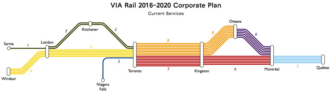
Diagrams I made of the service patterns described in the 2016 corporate plan:
"Current" services (2016)
"Year 1" services (proposed for 2017):
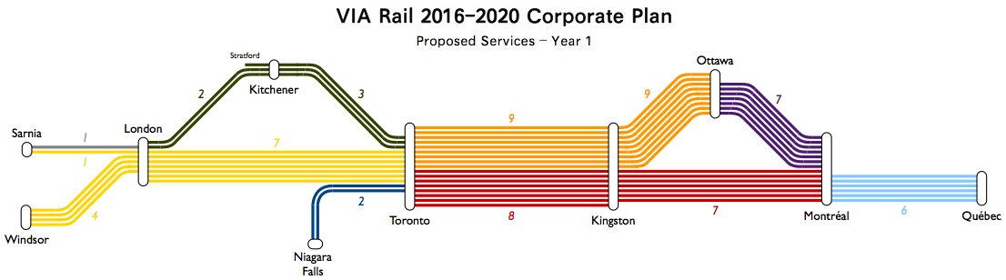
The only part of the plan which was actually achieved was the extra service between Toronto and Ottawa.
oh thats right I forgot they tore it up ha.
One idea I've toyed with is to interleave the lines from Sarnia and Windsor through London. Essential most trains leaving Sarnia and Windsor travel the direct London to Toronto route but some travel the London-Kitchener-Toronto route.My favourite option for what to do with the RDCs is still what VIA had actually planned to do with them: run a standalone RDC service on the London-Kitchener-Toronto corridor and reroute the loco-hauled trains from Sarnia via Brantford. This would have cut more than an hour off the Sarnia-Toronto journey time.
Diagrams I made of the service patterns described in the 2016 corporate plan:
"Current" services (2016)
"Year 1" services (proposed for 2017):
The only part of the plan which was actually achieved was the extra service between Toronto and Ottawa.
One idea I've toyed with is to interleave the lines from Sarnia and Windsor through London. Essential most trains leaving Sarnia and Windsor travel the direct London to Toronto route but some travel the London-Kitchener-Toronto route.
My favourite option for what to do with the RDCs is still what VIA had actually planned to do with them: run a standalone RDC service on the London-Kitchener-Toronto corridor and reroute the loco-hauled trains from Sarnia via Brantford. This would have cut more than an hour off the Sarnia-Toronto journey time.
Diagrams I made of the service patterns described in the 2016 corporate plan:
"Current" services (2016)
"Year 1" services (proposed for 2017):
The only part of the plan which was actually achieved was the extra service between Toronto and Ottawa.
I have 2 requests. (I may have more eventually...)
1) Can you show what the proposed HFR look like?
2) Can you do this for the whole Via system?
1) Can you show what the proposed HFR look like?
There aren't yet any specifics on the service under HFR, so it would have to be based on my own fantasy service patterns.
/arc-anglerfish-tgam-prod-tgam.s3.amazonaws.com/public/O7F3SOPZHVESTEZDAMMVVQ7SEA.jpg)
 www.theglobeandmail.com
2) Can you do this for the whole Via system?
Out of curiosity what did you use to draw those line diagrams?
2) The Corridor is pretty much the whole VIA system. The rest of the network has only a single train per day or less, so my service map would just be the same as the ordinary network map.
1) There aren't yet any specifics on the service under HFR, so it would have to be based on my own fantasy service patterns. If you'd asked a couple weeks ago I'd probably have done it, but now my summer holiday is ending so I probably won't get around to it.
Supposedly, 15 trains per day on Toronto-Ottawa-Montreal and 18 trains per day on Montreal-Quebec. Based on this article:
Internal documents challenge Via Rail’s business case for extending new rail line to Quebec City
Via’s plan for a new dedicated passenger rail line would mean reduced services for cities along the existing line
I'm guessing that Kingston-Toronto, Kingston-Ottawa and Kingston-Montreal will all be at 4-6.
Out of curiosity what did you use to draw those line diagrams?
There is really no point. The scales are different with every line outside the Corridor being less than daily.