News   Apr 23, 2024
 269     0 
News   Apr 23, 2024
 471     0 
News   Apr 22, 2024
 1.3K     0 

Discontinuous streets

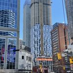
As far as I can tell, Morrison St, which runs south of Adelaide between Bathurst and Brant, has never quite connected with King: there's a curb cut but no street sign and a sort of laneway between the two buildings that are there, one of them on the site of a former gas station.

1910 map:
Morrison St.jpg


View southwest-ish to King showing pedestrianized laneway:

IMG_5277.JPG
 

Attachments

  • IMG_5277.JPG
    IMG_5277.JPG
    767 KB · Views: 764
  • Morrison St.jpg
    Morrison St.jpg
    56.6 KB · Views: 778

My grandfather grew-up in a house at 11 Lyon Avenue (Toronto) back in the 1920's. While I understand that the name of the road was changed to Marlee Avenue in 1953, I wonder if they kept the same house numbers. In other words, is the house seen today (in Google maps) at 11 Marlee Avenue, the house my grandfather lived in as a boy?
 
Gerrard and Carlaw.... where there are two separate roads called Gerrard St. East.

Gerrard doesn't split at Carlaw, it splits at Coxwell. And that was because there was a gap between the two sections, between Greenwood and Coxwell. The original intent was to continue the section of Upper Gerrard down to meet with the lower section, but instead they decided to extend Eastwood across to the west.

Dan
Toronto, Ont.
 
Another interesting street to add to the list...

Riverside Trail (near the Humber River). I'm not sure the history but the road ends at a series of steps down the steeper part of the embankment. And then the road starts up at the bottom.

I wonder how many other roads were replaced by stairs (maybe when automobiles became the main form of transport?)
 
Click map below. You'll see how Gerrard splits at Carlaw, or to be accurate, was split in the past, and now buildings separate the two Gerrards.

https://goo.gl/maps/V6ptPhSPwFr

Oh, you're referring to the jog. Well, it hasn't been a jog in 80-some-odd years, and that little section hasn't been connected to the main part of Gerrard for 13 or 14.

Dan
Toronto, Ont.
 
Yup. A lot of those jogs have been worked out during the process of road widenings, but roads like York Mills and Finch have 4 or 5 jogs in them at various lines.

I just wish they would have decided to use 800m instead of 2km as the default length. It would have made creating an urban/suburban transit grid so much easier. Of course, I can understand why they did use 2x2km, but still. 800m IMO is the perfect grid size for a suburban environment.

I'm old enough to remember when the jogs of east-west roads such as Finch and Sheppard at north-south roads were actual jogs - two offset T-intersections. I was told that this was because the surveys were shot northward from Lake Ontario and reflect the variations of the shoreline. Notice that the surveys starting in what is now Peel run noticeably N/W which is perpendicular to the shoreline in that area. The former Toronto Gore Township (a 'gore' being a triangle-like area where adjoining surveys do not close) between Brampton and Vaughan was created to bring these variations together. No doubt error corrections played a part since townships were laid out at different times with the equipment of the day.

When I was growing up, concessions were 1.25 miles, which is 6600 feet or 100 chains. Chains were a standard, durable survey measurement and, of course, the Imperial system of measurement with its none-linear units was the rule of the day in a colony. It would be pretty unrealistic to expect the folks of the day to have foreseen a system that didn't yet exist (metric did exist, but it was not standardized and only used by those weird people on the Continent).
 
Interesting note about Gore.

Other reasons for jogs are. Chains are flexible and workers didnt exactly have laser level checks. Workers would literally walk the chains out and so any tiny variance from perfectly straight creates a jog. Also remember that two "parallel" streets running N-S will slowly converge on a point (the northpole) so in order to keep plots perfectly square N-S streets would need to shift apart every sp often. This is more visible in the praries though where thers are wide expanses of flat land and larger plots.
This also explains why Saskatchewan's eastern boundary isn't perfectly straight.
 
  • Like
Reactions: vic
A few small ones from around my part of town, The Junction Triangle:


Also nearby, Old Weston Rd. famously disconnected when the bridge over the tracks was removed: https://www.google.com/maps/@43.6662971,-79.4584803,17.25z?hl=en

Honourable Mention:
In Etobicoke, Bloor St. at the Six Points interchange doesn't connect to itself, but it will soon when that whole mess is re-jigged. https://www.google.com/maps/@43.6410765,-79.5352514,18.08z?hl=en
 
Click map below. You'll see how Gerrard splits at Carlaw, or to be accurate, was split in the past, and now buildings separate the two Gerrards.

https://goo.gl/maps/V6ptPhSPwFr

Huh!, I grew up in that neighbourhood and remember how it was before it was cut off from the "main" Gerrard St. E. When they closed it off, I didn't realize it was still called Gerrard St. E!
 
Steeles Avenue is discontinuous in Milton at Crawford Lake. From the Flamborough (Hamilton)/Burlington boundary to Guelph Line, that discontinuous stretch of Steeles was renamed Conservation. Otherwise, Steeles Avenue/Taunton Road is continuous from Appleby Line in Milton to the Clarington/Port Hope boundary.

Funnily enough, Steeles/Taunton almost goes from Hamilton (amalgamated city) to Hamilton (township).
 
Click map below. You'll see how Gerrard splits at Carlaw, or to be accurate, was split in the past, and now buildings separate the two Gerrards.

https://goo.gl/maps/V6ptPhSPwFr

Interesting. I've always noticed that odd street, never the street name. Must be hard for delivery people. Today was just thinking of the offset on Gerrard at Broadview. Noticing your post decided to look it up. See no explanation. I know Gerrard used to be called Don Street between Parliament and the valley. And looking at an 1889 map it says west of Broadview Gerrard was formerly known as Josephine. East of Carlaw right by the Jewish cemetary it says it was formerly Ramblers Rd. Lol, ramblers...first I've heard of that. Can't find any maps that show either Josephine or Ramblers, which would be sometime before the 1880s I guess. A 1902 map shows your Gerrard split being called "Subway" but little info on that either. Riddles for the time being.
 

Back
Top