News   Mar 28, 2024
 14     0 
News   Mar 28, 2024
 202     0 
News   Mar 27, 2024
 2.1K     1 

Historic photos from Toronto on this day

(more) November 17th: Three photos from 1897, 113 years ago in Beaconsfield Village of the men and horses building the subway under the tracks along Queen Street at Dufferin.

s0376_fl0002_it0010.jpg


s0376_fl0002_it0008.jpg


s0376_fl0002_it0009.jpg


Lots of interesting details in these photos, like the Union Hotel and the original top of the tower on the Gladstone Hotel. Interesting to visit there on Google Maps, and see that most of this stonework survives. Here's a close up of the south east corner from Google Street view:

1897-queenst-subway.jpg


I've geo-tagged more historic photos that you can see here on the map.

For links to the City of Toronto Archive details on these photos, see the Nov 17th Historic Toronto photos page.
Good timing on these ones with the new tunnel opening on Dufferin. No more "jog".
 
November 18th: (I've got some catching up to do...) - I've lost the link to 'St. Pauls Cathedral iron gate at Colborne Lodge - Illustrated guide to Toronto by way of Niagara Falls' that I dated Wed Nov 18th, 1875, I'll have to see if I can find it again.

In 1928 we have an interesting juxtaposition between the T.T.C. armistice parade, at the cenotaph outside Old City Hall, and Canadian Bank of Commerce, Ritz Hotel, 'Good Things to eat', Lux and Milk Chocolate ads in the background.
s0071_it6462.jpg


Then in 1936 we have two photos from Corktown of houses along Trinity street - first the back of 103-107 Trinity Street
s0372_ss0033_it0088.jpg


And then the front of 100-102 Trinity Street:
s0372_ss0033_it0087.jpg


And in the background we have the (or another) holding tank. 102 Trinity is currently closer to King St than to Eastern, so I'm not sure if it is the same tank as the one we see in the Nov 17, 1926 photo.

(Details on these photos is available on the Nov 18th Historical Photos page.)
 
November 19th: Lots of photos ranging from 1918 to 1980, starting with a view looking south on Trinity Street, showing to the right the M. E. K. still and tank houses in the Distillery District in 1918, 92 years ago:
f1583_it0061.jpg


Then an emotionally charged photo from 1923 of three wild street children preparing to storm the barricade by the Avoca Ave bridge, just south of St. Clair in Moore Park.

s0372_ss0060_it0029.jpg


Apparently this was a co-ordinated effort, as on the same day, on Davenport, looking west from Bathurst, we see two more children ready to storm the TTC barricades as well:
s0071_it2756a.jpg


Then in 1924 we have crowds gathered for the Township of York Railways opening ceremony at Rogers Road line on Oakwood Avenue just north of St. Clair:
s0071_it3524.jpg


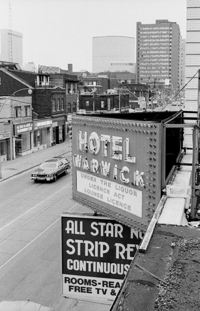
And finally, an excellent set of photos by Collations from 1980, 30 years ago, of the Hotel Warwick which was originally built in 1910 as the Royal Cecil Apartments. Check out all 72 photos of the interior, then spend the rest of the aftenoon looking at the countless other photos by Collations! - Here's the link to the Flick set.

3846877905_9bf1a9899e_z.jpg


(Check out the November 19th Toronto Historic photos page for all the details and locations.)
 
In 1928 we have an interesting juxtaposition between the T.T.C. armistice parade, at the cenotaph outside Old City Hall, and Canadian Bank of Commerce, Ritz Hotel, 'Good Things to eat', Lux and Milk Chocolate ads in the background.
s0071_it6462.jpg

Another notable feature of the area cannot be seen in that photo.
I have a distinct recollection of that office building on the left (Commerce) because, at the very top, it had an electric news banner such as this one in Times Square.
That was a novelty in Toronto and a crowd pleaser.

Times-Square.jpg
 
Another notable feature of the area cannot be seen in that photo.
I have a distinct recollection of that office building on the left (Commerce) because, at the very top, it had an electric news banner such as this one in Times Square.
That was a novelty in Toronto and a crowd pleaser.

Interesting... the only photo I could find in the archives that show the top of the building is from 5:15 on April 13, 1923 -- long before the sign you're talking about:
s0071_it2004.jpg


(More photos from Bay and Queen St, here.)
 
November 20th: We start on Eglinton Ave west, looking east towards Yonge street from Oriole Parkway in 1928, as Chaplin Estates to the south was being built. The two story building in the distance, on the north side of Eglinton is the Hydro transformer station, which is still there today.
f1231_it1227.jpg


Then in 1953 we have a set of 10 photos of the underpinnings of Rosedale Subway station:

s0381_fl0278_id11442-9.jpg


s0381_fl0278_id11442-8.jpg


Finally, we head just a bit south to the north-east corner of Yorkville and the 'butterfly' canopy over the Canadian Tire gas bar at Yonge Street and Church Street in 1959 (as discussed recently in another thread here):

s0372_ss0100_it0442.jpg


(Actually, the archive indicates the date as Nov. 1959 but I guess I geo-tagged it yesterday, hence the specific date...As always, you can see the details and locations of these photos, including the link to the other 8 Rosedale Subway station photos, on the Nov 20th Historical Photos page.)
 
Another notable feature of the area cannot be seen in that photo.
I have a distinct recollection of that office building on the left (Commerce) because, at the very top, it had an electric news banner such as this one in Times Square.
That was a novelty in Toronto and a crowd pleaser.

The building was known as Manning Chambers--but interesting if there are no photos extant of said ribbon, anywhere. (Was the site at all photo-documented prior to site clearance for New City Hall/NPS?)
 
November 21st: One of the older photos in the collection today, from 110 years ago - of the construction of the 'new market' in the St. Lawrence Market on the west side of Jarvis in 1900:

s0376_fl0002_it0101.jpg


Then in 1918 we have an annotated photo of No 62. Plant from Parliament Street down in the Distillery District:
f1583_it0062.jpg


Then in 1921 the Archives has a LOT of photos traveling up Yonge Street from north of St. Clair. I didn't geotag them all, but here are a few more notable ones... Starting with an old Metropolitan Railway building on the west side of Yonge Street just south of the Beltline trail, west of The Mount Pleasant Cemetery:
f1231_it0420.jpg


Then farther north we have Davisville Church, at 1992 Yonge Street at the end of Belsize Drive on the east side of Chaplin Estates:

f1231_it0353.jpg


And then row houses No. 2042-2052 Yonge Street, at the corner of Lola Road:
f1231_it0854.jpg


Anyone care to measure the length of the shadows to estimate the time of day this photo was taken?

(Details on all these historic Toronto photos available here. )
 
November 22nd: Another full day of photos! We start back in 1913, looking at the Bickford Ravine, before it was filled in. The bridge we're looking at is Harbord Street, and you can still see the guardrail there today, although the ravine itself is filled in:

f1231_it1889.jpg


Then we're back for more photos on Yonge Street near Eglinton in 1921, carrying on where we left off yesterday in North Toronto - first we start with Postal Station K, No. 2388 Yonge Street, formerly Oulcott's Hotel, torn down in the 1930's:

f1231_it1112.jpg


North of that is the Bank of Montreal building at 2444 Yonge Street at Roselawn:
f1231_it0595.jpg


Then north to 2486 Yonge Street, southwest corner of Yonge Street and Castlefield Avenue - Cumming Brothers Auto Accessories - Vulcanizing - "Dominion Tires are GOOD tires" don't you know:

f1231_it0701.jpg


Right next door, across the street we see 2490 Yonge Street, with the Capitol Theatre built, but the rest of the building not built up like it is today - the corner was the W.G Simpson Real Estate office, and maybe a Dominion Grocery? The movie advertised is 'Cappy Ricks' a silent film from 1921 - the IMDB database doesn't have much to say about the film except "Reels 2 and 4 of this six-reel film survive in the UCLA Film and Television Archives". Growing up in the neighbourhood I've seen a few movies at this theatre, including The Gods Must Be Crazy - I still buy Gelato in the little 1/2 shop there.
f1231_it0724.jpg


A few blocks north we get to the northwest corner of Craighurst and Yonge:
f1231_it2138.jpg


As I said yesterday, there are a lot more photos from November 21/22 1921 of Yonge street...

But now we'll move on to 1924 and a 'before' picture showing the dangers of no safety boulevards for the streetcars at Spadina and Dundas in what is now Chinatown- we cyclists have been getting a bad rap for years!

s0071_it3540.jpg


Finally we end November 22nd in 1934, and the new Armories on Fleet Street by historic Fort York:
f1231_it0593.jpg


( Details on all these pictures on the November 22nd Historic Toronto page.)
 
Last edited:
seemsartless: the Gladstone hotel's tower is indeed gone of course, but at the base there was/is a room; it's still in use and is called the "penthouse suite" by the hotel management. It's the second floor bedroom of the room at the southwest corner. I saw it at a Doors Open a couple years ago.
 
seemsartless: the Gladstone hotel's tower is indeed gone of course, but...I saw it at a Doors Open a couple years ago.

Interesting, I'll have to watch for it next year in Door's Open....

November 23rd: Not to go on about it everytime I post one of his pictures, but our friend Collations has an amazing collection of Toronto photos - here's an example of a mid-19th century 'Gothic Cottage' - this one is at 756 Palmerston Ave in Seaton Village shot on Nov 23rd 1997:

3908636532_3b8bdde792_z.jpg


(For details on this photo see the Flickr page.)
 
Sorry everyone ... that's 756 Markham St, and not Palmerston Ave. I've corrected this on flickr, as well as an earlier version of this from 1990that I misidentified as Clinton St! A quick check on Google Street View tells me that this little cottage is overdue for an updated reshoot.
 
Well, I suppose it might be for something other than gas, but it’s on the north side of Mill Street:

Ah, yes, thanks. The nearbye Molasses tanks in the Distillery, which were considerably smaller, are shown in the additional images you posted ( and there's a reference to one being covered in the mysterious "Hippo Paint", which I believe had us scratching our heads over several months ago ).
 
Thanks @Collations, I'll update my geo-tagging too!

November 25th: A collection of photos from around Yonge and Lawrence today, starting back in 1920 (not from the 1921 collection, surprisingly) of 3296 Yonge Street, the Bedford Park Hotel (that gave the area, Bedford Park, its name) just south of Fairlawn. I suspect this IS part of the 1921 set of photos, with the year written incorrectly on the photo.

f1231_it1111.jpg


Then in 1921 we have the Ellis Estate gates looking a bit worse for wear on the north-west corner of Bedford Park Road and 2708 Yonge Street.
f1231_it1549.jpg


Here's a better view of the carvings and the name 'Knockaloe' on the gate from a couple of years earlier:
f1244_it0308.jpg


Then we have two photos of the John E. Atkinson Grocery store at 3162-3164 Yonge Street:

f1231_it0713.jpg

f1231_it0743.jpg


Details on all these Bedford Park photos available on the Nov 25th Historical Photos page.)
 

Back
Top