News   Apr 18, 2024
 691     1 
News   Apr 18, 2024
 1.5K     3 
News   Apr 18, 2024
 387     0 

Gated community in Rouge Park?

Lone Primate

Active Member
Member Bio
Joined
Aug 16, 2007
Messages
987
Reaction score
145
Location
Don Mills Willowdale Park Forest something I dunno
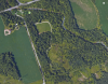
The area just southeast of Reesor Road and Steeles Avenue, and north of the track of Passmore Avenue, today looks like the attached image from Google Maps.

Park 2017.png


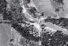
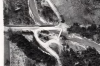
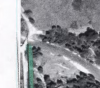
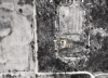
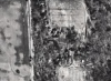
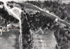
But in 1971, the three captures from the City's aerial photos seem to show a lot of homes in there. Are these homes in some private community? Or was this some resort with cottages in it? What was this place? Does anyone know?

Park 1971 1.png

Park 1971 2.png

Park 1971 3.png
 

Attachments

  • Park 2017.png
    Park 2017.png
    1.3 MB · Views: 1,297
  • Park 1971 3.png
    Park 1971 3.png
    888.3 KB · Views: 1,181
  • Park 1971 2.png
    Park 1971 2.png
    838.7 KB · Views: 1,184
  • Park 1971 1.png
    Park 1971 1.png
    791 KB · Views: 1,247
Excellent observation and questions, Lone Primate.
I look forward to the answers.
 
Most likely some scout camp/cottage community sort of thing--in fact, I may have even driven into there (the parking at the Steeles end) for a bathroom break and stroll 10-15 years ago and *perhaps* saw some evidence thereof (plaque?)
 
I read that it was flooded out during Hurricane Hazel.

When we moved back to Toronto in the late 70s there was a trailer park there.
 
Last edited:
Heavens, folks. And thanks, Northern Light :) -- I'm glad it's still a park we can all enjoy. But oh, what a loss... what a place it must have been.
 
Related to that... isn't this an interesting configuration for the conjunction of Steeles Avenue and Reesor Road? This is from 1956, at the north end of the park... Apparently there weren't a lot of folks just roarin' through there back in the day. :)

Screenshot from 2017-07-23 21-40-49.png
 

Attachments

  • Screenshot from 2017-07-23 21-40-49.png
    Screenshot from 2017-07-23 21-40-49.png
    1.2 MB · Views: 1,033
Given how this was only a couple of years after Hurricane Hazel, I'm wondering whether that was, to whatever greater or lesser degree, a "temporary" configuration (Bailey bridge, perhaps?)

Or if not, I'm wondering when Steeles was "straightened" with the present highway/arterial-level crossing--maybe not too long after this; and just generally, it was in the post-Hazel period when the present paved/improved county/regional road network (flowerpot signage etc) began to gestate, and when examples like Airport Road broke the King's Highway monopoly on long-distance paved travel. Thus, Steeles through the Rouge Valley represented the new almost-as-good-as-a-highway paradigm, even if it still took another third of a century or so to be connected to Taunton Road in Durham Region...
 
Or if not, I'm wondering when Steeles was "straightened" with the present highway/arterial-level crossing--maybe not too long after this;

The 1959 aerial shot seems to show this little bridge in situ, but a straight-across Steeles bridge looking rather under-construction; possibly the one we still have because even in 2017, that bridge ain't much. I don't see any evidence of a previous Steeles bridge here; no abutments, no straight-away vanishing into the river suddenly... I think they did what the 19th century so often did -- angle the bridge to the shortest (cheapest) distance and count on low speeds and even lower traffic volumes to keep it from being an issue. Anyway, in 1957, there's no hint of the "new" bridge, so sometime between '57 and '59. Likelier 1959.

Screenshot from 2017-07-25 19-56-48.png


I don't think it was a replacement bridge. It looks pretty much the same in 1953, predating Hazel... Well, put another way, if it was a replacement bridge, they put it in the same place the previous one had been before the hurricane.

Screenshot from 2017-07-25 19-50-17.png
 

Attachments

  • Screenshot from 2017-07-25 19-56-48.png
    Screenshot from 2017-07-25 19-56-48.png
    849.1 KB · Views: 984
  • Screenshot from 2017-07-25 19-50-17.png
    Screenshot from 2017-07-25 19-50-17.png
    262.9 KB · Views: 960
Also makes sense relative to my birth-of-the-county-road-network theorem; the scale of the bridge and the widened Steeles to its west is like an emphatic jolt into highway/arterial-scale modernity. And unlike, say, the Don Mills/DVP-spurred Lawrence/East Don rebuild at the same time, it didn't serve insta-sprawl; it served what was (at least for the moment) rural territory.

One thing I remember from the 80s here: a directional sign to Hwy 48 (Markham Rd) which used a white crown symbol more typical of (if simpler than) the 400-series--I wondered if it was meant as a harbinger for others, maybe displacing the King's Highway shield...
 
This was posted some time ago, but I just found this site today and wanted to respond. There was indeed a "gated community" in what is now Rouge Park. It was called Woodland Park and it was a private cottage community. My family had a cottage there that my grandfather built in the early 1900's (it is one of the buildings on the left across from the large open field in the second and third photos above).

Most of the families knew each other and spent summers there - moms and kids stayed at the cottage, while dads commuted to work! Indoor plumbing was rare - we had an outhouse and got water from a pump that drew from the Little Rouge. Very few cottages were winterized though our neighbors' was and they served as caretakers for the park during winters.

The river had a dam and swimming and fishing were popular. Later a campground was opened in the area of the second large open field and the public could camp for a fee. I spent 15 summers there with my family before the land was expropriated for the Pickering Airport, which never materialized. Cottagers were paid only for their land not for any improvements to it (the building). My family lost a summer home that had been in the family for 65 years.

While before my time, I am told that Hurricane Hazel washed out three cottages on the road into the park and did major damage to the bridge on Reesor Road just before the gates to Woodland Park.

I grew up in Toronto and to this day it amazes me that we had a cottage so close to the city, but felt so far removed from civilization. It was an incredible place to spend summers growing up (many Indian arrowheads were unearthed there).
 
I grew up in Toronto and to this day it amazes me that we had a cottage so close to the city, but felt so far removed from civilization. It was an incredible place to spend summers growing up (many Indian arrowheads were unearthed there).

Same here. Grew up around Finch and Bathurst when both were two-lane roads and we fished in the Don where the G Ross Lord dam is now. Trips along roads like Steeles or Finch east of Bayview were truly drives in country. Towns like Richmond Hill and Markham were just that - towns, and Thornhill was barely a village.
 
Towns like Richmond Hill and Markham were just that - towns, and Thornhill was barely a village.

Markham (at least the Markham Village/Unionville area) didn't even have a McDonalds as late as 1981! Possibly elsewhere in the municipality like along Steeles west of the 404, but not there.
 

Back
Top