Toronto Ontario Line 3 | ?m | ?s

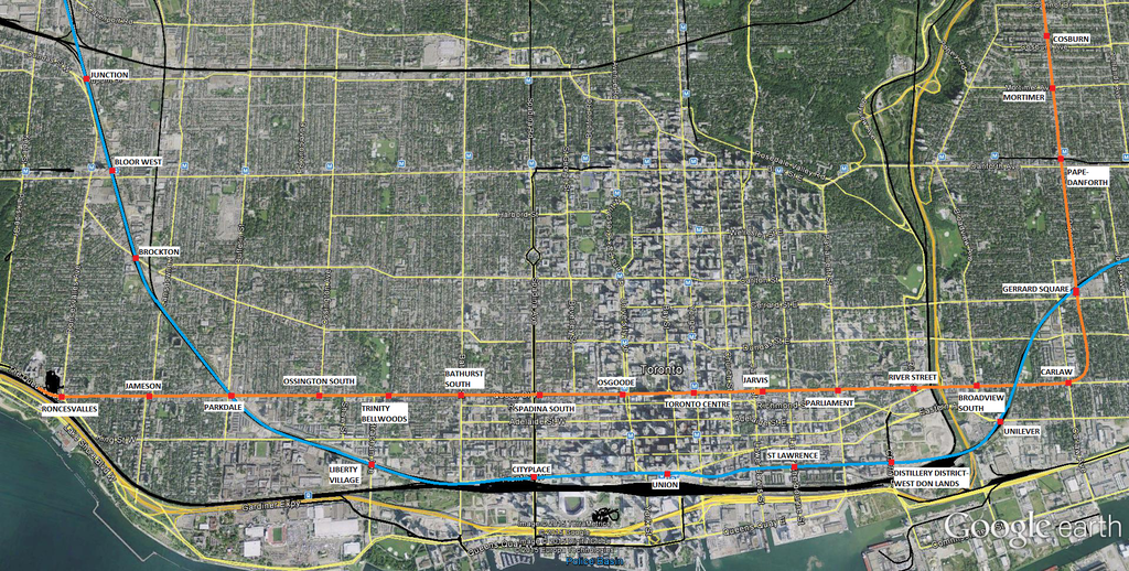
I think at this stage what's on the site is just going to confirm what everyone thought to begin with. I read the same maps and came away still thinking Pape/Wellington was the best alignment. You can't go along Queen "with a connection to Unilever" in any practical way - it's a third of a mile away.

I still think an alignment further south has more advantages. The big increases in density are along and south of Front. That band has little in the way of east/west local transit, and RER is not going to do it much good. Queen already has transit - putting the subway there means you have two lines in a low-rise zone and none in a high-rise zone, or you get rid of the streetcars, and then have to build more subway stations, which will put pressure on to tear down the old fabric all along the street.

A southern subway line would leave the existing lines in place and add a subway linking Gerrard Square, Unilever, West Don Lands, Distillery, St. Lawrence Market, the financial core, new developments south of Front, the convention centre zone, City Place, Liberty Village, and the Exhibition.
Queen Street already has transit? Surely you're not talking about the streetcar. By that definition every square inch of the city already has transit and we don't need to build any more subways anywhere. The whole point is that surface transit on the DRL route isn't getting the job done. The central portion of the Queen streetcar could be removed after the subway opens, like the Yonge and Bloor streetcars before it.

All of the neighbourhoods you listed will be well served by RER. They aren't in the dire transit situation that neighbourhoods farther north are. If you're concerned about having two lines next to each other, a subway and an RER line is a far bigger duplication than a subway and a streetcar.

I'm not saying that the King route doesn't make sense, just not for the reasons you mention.
 
A5RsH55.jpg
 
Here are some images, to make it easier for those wanting a look or to quote the different alignments. As it stands, I'm liking Option A.

Corridor_Evaluation_Future Extension - small.jpg


Option A
Corridor A - small.jpg

Option B
Corridor B - small.jpg

Option C
Corridor C - small.jpg

Option D
Corridor D - small.jpg
 

Attachments

  • Corridor_Evaluation_Future Extension - small.jpg
    Corridor_Evaluation_Future Extension - small.jpg
    473.2 KB · Views: 514
  • Corridor A - small.jpg
    Corridor A - small.jpg
    319.2 KB · Views: 484
  • Corridor B - small.jpg
    Corridor B - small.jpg
    323.9 KB · Views: 497
  • Corridor C - small.jpg
    Corridor C - small.jpg
    309 KB · Views: 483
  • Corridor D - small.jpg
    Corridor D - small.jpg
    311.8 KB · Views: 521
I like option D as well but routing will need to be careful.

One thing to note. A couple months back in conversation with some of the TTC staff and engineering experts. they noted that tunneling under the west don lands was tricky on two accounts. Firstly, Corktown Common and other parts of the West Don Lands area were placed on foundation stilts that run down to bed rock and there weren't necessarily given any strategic gaps or corridors purposely created to thread a subway through them in the future.

Secondly, tunneling through a flood protection berm mitigates the value and use of a flood protection berm.
Same goes for any sort of penetration of the rail berm, be it by stations or tunnels etc. The rail berm is part of the flood protection system.

Another key factor was the depth of stations required should stations be wanted here. building stations and tunnels deep enough into bed rock so as not to compromise the flood protection means added costs to station construction. Additionally to meet fire safety standards and facilitate connection of people to the surface and other intersecting services eg SmartTrack they would need high speed elevators to e able to clear the platforms and station in a sufficient amount of time. these things add big to the price tag as we can all imagine
 
Why tunnel? Monorail could be built for a fraction of the cost, in a fraction of the time. Oh that's right, because if it's not heavy subway, it can't possibly be a serious transportation solution. How silly of me.
 
I think with Smarttrack in the mix, the Queen/Pape (Corridor B) is the best choice now, as you don't want the services competing (like with Smarttrack/Scarb subway) and it makes two alternatives for downtown located in the city in different areas. Also, that alignment seems to have the highest ridership per stop (all green) It also connects to the Lakeshore GO Line, which would create a mobility hub and take the load off Union (people would get off here and transfer to DRL to get to downtown)
 
Option A is completely out then when you read the evaluation. No interchange with SmartTrack or GO, among other issues. Clearly chosen to fail!
 
I think with Smarttrack in the mix, the Queen/Pape (Corridor B) is the best choice now, as you don't want the services competing (like with Smarttrack/Scarb subway) and it makes two alternatives for downtown located in the city in different areas. Also, that alignment seems to have the highest ridership per stop (all green) It also connects to the Lakeshore GO Line, which would create a mobility hub and take the load off Union (people would get off here and transfer to DRL to get to downtown)
Pretty much my opinion too.
Since SmartTrack (GO RER) through the downtown is a Good Idea and really should happen, there's no need for the DRL to duplicate the coverage it provides. The financial district is still within a 3 block walking distance.
The distance between the DRL and RER will be a little more than the distance between Yonge and University, which is a reasonable spacing for coverage of an urban centre.
 
Option A is completely out then when you read the evaluation. No interchange with SmartTrack or GO, among other issues. Clearly chosen to fail!

Pretty much my opinion too.
Since SmartTrack (GO RER) through the downtown is a Good Idea and really should happen, there's no need for the DRL to duplicate the coverage it provides. The financial district is still within a 3 block walking distance.
The distance between the DRL and RER will be a little more than the distance between Yonge and University, which is a reasonable spacing for coverage of an urban centre.

I personally believe that they are leaning towards Corridor D, but Corridor B is also a worthy contender IMO

Corridor A is a clear loser. It provides zero neighbourhood access East of the Don. No connection to GO RER or SmartTrack. Does not support future development in the West Don Lands that we know will happen. No direct connection to Greenwood. And no connection to Unilever. With Tory as Mayor, and him being best buds with First Gulf, can you imagine them not lobbying him for a DRL connection? Please. I can't see this one going forward.

Corridor B is good. Lots of neighbourhood access East of the Don. Potential connections to GO RER/SmartTrack at Gerrard Square AND Unilever. Provides direct access to Eaton Centre, City Hall, St Michaels Hospital - all big destinations. Supports Regent Park revitalization. Potential direct connection to Greenwood yard. It doesn't directly serve the Financial District, but it's pretty close. The biggest problem with Corridor B is the tunneling through the flood protection landform.

Corridor C is an odd one. It provides neighbourhood access East of the Don, but with the stations being on Broadview, it really reduces the impact of the stations, as it would be serving a small catchment area due to the Don Valley on the west side of them. If you are going to provide stations in East York, then you might as well provide stations with the most impact. No connections to GO RER or SmartTrack. No direct access to Unilever. It also has to tunnel through the flood protection landform and under King Street. If you want to serve King Street, you are better off going with Corridor D IMO.

Corridor D is just as good as Corridor B, IMO. Connects to all the streetcar lines in the area, as well as the future waterfront LRT system. Lots of neighbourhood access East of the Don. Connections to GO RER & SmartTrack at Unilever AND at Gerrard Square. Direct access to the Financial District. Provides access to tourist nodes such as St. Lawrence and Distillery District. Serve George Brown College, which is a big east-side trip generator. Supports future development in the West Don Lands. Potential direct connection to Greenwood. The biggest downfalls are the tunnel through the FPL and the potential complexity of tunneling under King Street.

Honestly, looking at that list, Corridors B and D are the frontrunners IMO.
 
Last edited:
IMHO Corridor D edges out B slightly because it will (mostly) negate the need for some riders to transfer from the DRL to join Line 1 peak flows. It's not a big deal if someone in the AM transfers from DRL to Line 1 NB to get to Queen, but the reverse (Queen->King) will have a negative impact on SB capacity. Don't underestimate riders' willingness to transfer for just one stop!

This will become more of an issue if the DRL is extended north to Eglinton or beyond as you will have more people who find that the speed advantage of the DRL outweighs the necessity of the transfer.
 
From what has been presented, I think option B with a downtown alignment along Richmond or Adelaide is the way to go. Hopefully they would be able to tunnel between the supports for both the Queen bridge and the FPL. Station box construction for the CBD station would be less disruptive on one of those streets than Queen or King. It also maintains a distance between the Relief Line and the RER.
 

Back
Top