News   Apr 23, 2024
 1.4K     4 
News   Apr 23, 2024
 512     0 
News   Apr 23, 2024
 1.2K     0 

Urban Wilderness!

Highland Creek - connect the branches

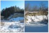
My never-ending tour of this massive system resumes near Lee Centre Drive, on the opposite side of the 401 where I began my exploration of the Western Branch back in the summer:

65331840.jpg
65331859.jpg


65331878.jpg
65331887.jpg


Heading southeast under Progress Ave:

65331899.jpg
65331934.jpg


65331947.jpg
65331919.jpg


65331968.jpg
65331986.jpg


From Bellamy to Markham Road:

65332006.jpg
65332029.jpg


65332042.jpg
65332047.jpg


65332059.jpg
65332068.jpg


65332077.jpg
65332088.jpg


65332136.jpg
65332161.jpg


65332179.jpg
65332193.jpg


65332203.jpg
65332213.jpg


65332225.jpg
65332233.jpg


Into the cavernous Morningside Park:

65332244.jpg
65332256.jpg


65332268.jpg
65332297.jpg


65332303.jpg
65332309.jpg


65332314.jpg
65332323.jpg


The creek forks at the centre of the park:

65332328.jpg
65332333.jpg


65332339.jpg
65332344.jpg


North now, up the Central Branch branch, where one encounters a quite large, and most interesting ruin - "The Bitch". I'm not exactly sure what this used to be. An army bunker? Part of an old bridge? The remnants of a mill perhaps? Apparently parts of the park were inhabited up until the 1950's, so maybe it's the remains of an old house, built too close to the creek. Anybody know?

65332348.jpg
65332350.jpg


65332355.jpg
65332360.jpg


My journey concludes at the opposite side of the 401 where I began my exploration of the Central Branch back in the fall:

65332366.jpg
65332368.jpg


65332375.jpg
65332382.jpg
 

Attachments

  • Screen shot 2012-01-22 at 1.44.07 PM.jpg
    Screen shot 2012-01-22 at 1.44.07 PM.jpg
    20.1 KB · Views: 442
Last edited:
Ah! I take it the ruin may be some former Scout facility then?

It was interesting reading about the "Swimming Hole" - the map I was using actually showed what appeared to be a small pond near where the ruin is, but it wasn't there when I arrived. I wonder if the ruin was part of the dam?
 
Ah! I take it the ruin may be some former Scout facility then?

It was interesting reading about the "Swimming Hole" - the map I was using actually showed what appeared to be a small pond near where the ruin is, but it wasn't there when I arrived. I wonder if the ruin was part of the dam?

I'm really surprised folks would go in for that sort of thing back then... I had the impression people lived in terror of polio every summer till about 1960.
 
Ah! I take it the ruin may be some former Scout facility then?

It was interesting reading about the "Swimming Hole" - the map I was using actually showed what appeared to be a small pond near where the ruin is, but it wasn't there when I arrived. I wonder if the ruin was part of the dam?

I don't believe the concrete work would be connected to the "Camp of the Crooked Creek."
The Boy Scout buildings were all log or wooden structures.
They also built log & rope bridges across the river.
No sign of the camp today except for an official plaque.

P.S. There once was a fine web site with many old photos of activities at the camp.
Unfortunately, the URL appears to have been appropriated for other uses (http://www.campofthecrookedcreek.com/).
Very disappointing!
 
Last edited:
This is a fun thread, thanks!

One watercourse that I think would be fascinating to walk would be Black Creek from the Pioneer Village to where it meets the Humber.

Afterwards, cross the Humber and say hi to Toronto's #1 Dysfunctional Family, the mayor lives almost right across from the confluence of the two waterways.

If you want info on the Black Creek, contact the Black Creek Conservation Project of Toronto's project coordinator. I volunteer with this group and the project coordinator is extremely knowledgeable about the creek.
 
I'm really surprised folks would go in for that sort of thing back then... I had the impression people lived in terror of polio every summer till about 1960.

But at least they didn't pave the whole thing over, like many of the other creeks for fear of encephalitis in the 70's and 80's.

...then again, there is something to be said for the "urban" look of many of these concrete creeks - such as the aforementioned Black Creek.
Although, as I can attest from first-hand experience, this hasn't cut down much on the mosquitos.
 
There once was a fine web site with many old photos of activities at the Boy Scout camp in Morningside Park.
Unfortunately, the URL appears to have been appropriated for other uses (http://www.campofthecrookedcreek.com/).
Very disappointing!

I tried that URL again today and it appears to have been restored - worth seeing!
 
It seems the camp site was much further south from where I was, according to that map.
I didn't get below Military Trail on my last trip.

Maybe next time!
 
East Don River - southern conservation

Though relatively short, this was definitely one of my most challenging treks. The Charles Sauriol Conservation Area, as the name would suggest, is not the type of urban wilderness meant for morning joggers and casual riverside strolls. Frankly, it's not meant for people at all - and it certainly does it's best to keep them out.

To demonstrate just how difficult a journey it is I'll start with a few pictures from an abortive 2008 attempt to penetrate this daunting terrain of steep cliffs and thick woods. Only a short way in from the forks of the Don the going got so tough that I was forced to make my way out, as I recall, through someone's Parkview Hill backyard!

12535257.jpg
12535321.jpg


65597578.jpg
65597570.jpg


I return on an unseaonably warm February morning. You would think the lack of snow would benefit my hike, but, in fact, it has turned the ground to a slippery stew of mud and slop, making my descent into the deep Don valley all the more treacherous:

65990100.jpg
65990125.jpg


65990110.jpg
65990113.jpg


I negotiate the rim of the hillside until I locate a fortuitously placed mountain bike path, complete with a rope system to lower yourself down:

65990131.jpg
65990136.jpg


Aparently mountain bikers have quite a time out here, for I find the ground littered with oyster shells and shards of shattered dinnerware:

65990118.jpg
65990121.jpg


These pictures really don't do the scene justice - there were literally hundreds of shells and smashed plates all over the place! Actually, this seems a fitting time to briefly revist some other odd edibles I've found floating around on my trips; from a bushel of apples in the Mimico, to watermelons and coconuts in the West Highland:

65989803.jpg
65989810.jpg


65989813.jpg


Unfortunately, the bike path doesn't last very long and I must go-it alone down a steep cliff face, itself littered with an assortment of other junk:

65990147.jpg
65990142.jpg


65990153.jpg
65990163.jpg


I make it safely to the bottom, all the while keeping in mind an incident 10 years ago when I tumbled headlong down a portion of the Scarborough Bluffs (but that's a story for another day):

65989782.jpg
65989783.jpg


Past the CN Rail crossing the footing is thankfully much more level:

65990164.jpg
65990166.jpg


65990172.jpg
65990180.jpg


65990186.jpg
65990190.jpg


North, through a hydro corridor, and I enter the grounds of Flemingdon Park Golf Club:

65990196.jpg
65990202.jpg


65990206.jpg
65990214.jpg


65990220.jpg
65990223.jpg


65990228.jpg
65990230.jpg


65990233.jpg


Further north to the Eglinton Avenue overpass:

65990236.jpg
65990243.jpg


65990246.jpg
65990249.jpg


65990253.jpg
65990258.jpg


I'm so busy photographing the underbelly's architecture that I'm almost oblivious to the train barrelling up behind me:

65994151.jpg
65994155.jpg


At this point I decide to quit while I'm ahead (and alive) an save the rest of the Charles Sauriol for another day...
 
I make it safely to the bottom, all the while keeping in mind an incident 10 years ago when I tumbled headlong down a portion of the Scarborough Bluffs (but that's a story for another day)

Uh oh, you're a ghost? :)

I love this pair, though... looks like POOF! Instant Building! :)

65990228.jpg
65990230.jpg
 
Ahh! Those hot summer days of youth.
I spent my tween/teenage years in Flemingdon Pk. and many hot summer days in this ravine. During the early tween years a favourite pastime was riding our bikes through the golf course, with golfers yelling at us to "get off the green!"
Just below the intersection of Wynford and St Dennis there is a dam in the river. The hole on the downstream side was our favourite for swimming. Once, during an especially strong summer rainstorm, a friend and I were body surfing down the river. Starting at the dam and ending a few hundreds yards down where an irrigation line was suspended over the water. The river was so high we just grabbed hold of the line and pulled ourselves to shore. This endeavour did not last long as the two gentlemen in the big yellow car thought it might be a little dangerous and asked us to leave.
We used this section of the valley as a short cut on our way over to Bermundsy Rd. The industrial area offered many hours of fun, with Peak Freens cookie plant, canadian tire, a condom warehouse, and Margret's donuts. Amongst others.
At that time we could easily make our own rail right of way adventures and traveled down to the forks regularly. In later years there was a teen killed down there. Hit by a train while attending one of the many beer drinking parties that took place in the valley.
We grew up, and trekking around the urban wilderness was no longer required. Cars, beer and music swayed our interest from fishing golf balls out of the river for a buck or two.
 
^I walked back home down Bermondsey - and I also found a golf ball on the other side of the river. But I threw it across back onto the golf course for free, like a sucker...

I love this pair, though... looks like POOF! Instant Building! :)

Haha! I didn't even notice that. That crazy new blue building is certainly hard to miss most of the time. You can even see it from Woodbine Ave, where I live.


On a somewhat related note, I just finished watching this great documentary about the famous London urban explorer Nick Papadimitriou:
http://www.youtube.com/watch?v=TNGskCNrBHY
A must watch for any fan of urban exploration.


PS
Speaking of London and Bermondsey Road, I noticed the TTC voice that announces stops on the bus pronounces Bermondsey with the stress on the "o" part....like BermONDsey. I always pronounced it more like "Bermundzy" as they do for the neighbourhood in London (or at least that's how I've heard Patrick Stewart pronounce it).

How did you pronounce it in those hot summer days of youth, mattelderca?
 

Back
Top