News   Apr 18, 2024
 462     0 
News   Apr 18, 2024
 3.5K     1 
News   Apr 18, 2024
 2.1K     4 

Transit Fantasy Maps

A Fantasy Subway Map of Ancient Roman Roads

From link.

940.jpg


3096bb247.jpg
 
A chance to do good with your mad map drawing skillz

You may remember me as transit editor last year - I moved to Newfoundland and am now a transit advocate here in St John's. One simple step forward would be to supplement the existing geographical map (http://www.metrobus.com/systemmap.asp#anchor) with a more schematic bus map that would show bus frequencies - usually hourly or half hourly (!), key interchanges and major attractions, with the harbour (which is the main reference point) aligned horizontally.

If one of you could mock this up - preferably as an editable file - maybe work with me a little to make it work, it would be a small but really helpful step forward for the hard-pressed public transit users here. If you can't do it yourself but could know someone who would, please also let me know.

map.PNG 
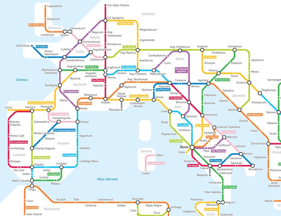
Central part of existing map

London-Central-Bus-Routes-Map.jpg The kind of simplified map I'd be hoping for and

st johns subway.jpg A local artist's joke transit map.
 

Attachments

  • map.PNG
    map.PNG
    2.1 MB · Views: 336
  • London-Central-Bus-Routes-Map.jpg
    London-Central-Bus-Routes-Map.jpg
    97.1 KB · Views: 349
  • st johns subway.jpg
    st johns subway.jpg
    85.2 KB · Views: 376
I posted this earlier in the DRL thread but it probably belongs here, meant as an alternative routing for the REM in Montreal:

Stations_REM_modified.png
 

Attachments

  • Stations_REM_modified.png
    Stations_REM_modified.png
    158.7 KB · Views: 976
I posted this earlier in the DRL thread but it probably belongs here, meant as an alternative routing for the REM in Montreal:

View attachment 127831

Makes way more sense.

The REM should use mainrail technology like GO-RER, something like the Bombardier Talent 2.

1200px-442_729_in_Nürnberg%2C_2014_%2802%29.JPG


Why? So it can easily be adapted to the Hudson AMT line in your map, and the tunnel on the Deux Montanges line can be shared with VIA Rails HFR proposal and the Mascouche Line.

Could still be automated with PTC.
 
Makes way more sense.

The REM should use mainrail technology like GO-RER, something like the Bombardier Talent 2.

Why? So it can easily be adapted to the Hudson AMT line in your map, and the tunnel on the Deux Montanges line can be shared with VIA Rails HFR proposal and the Mascouche Line.

Could still be automated with PTC.

That would also prevent them from having to re-convert the Deux Montagnes line from 25 kV back to 1.5 kV. Montreal has the potential for the equivalent to GO RER, but the REM prevents that from ever happening.

Although, the problem with the Bombardier Talent 2 is that the new Champlain bridge does not have enough additional strength for larger vehicles, which forces the light metro technology choice.

The Talent 2's are not much heavier than an LRT. They are pretty small in terms of North American mainline rail.
 
So I made a basic concept map based off the current GO System Map. What it shows, for the most part, are rail services promised in the original Big Move transit plan to be in place by 2031. The only exceptions are the service to Orangeville and Brantford, which I don't think were considered. One of the reasons for posting is Metrolinx's updated transit plan is official, and it shows much of these rail expansions falling by the wayside (by 2041 no less). I think some of this can be considered lack of foresight.

Yes electric trains with RER service is a big bonus and forward-thinking, but at the same time there are large swaths of the GTHA (and GGH) that are underserved by rail. Some areas are growing, some are seeing development leapfrogging farther out. Not saying we should serve everywhere, or go unrealistic distances, or go nuts envisioning high frequencies. But a few trains a day is very beneficial. Yes GO buses can serve many areas, but for the most part an intercity bus isn't nearly as attractive. Also parking lots on the existing corridors will be full at many stations, even the new inline stations proposed. Many will slog large distances to find a full lot, and logically decide to continue driving. With true rail expansion we can avoid a lot of that.

Gaps in GO rail network
GO-2041-underserved-by-rail.png


More or less Big Move GO vision, with Orangeville and Brantford added
GO-system-map-Bolton,Orangeville,Cambridge,Myrtle,Brock.png
 

Attachments

  • GO-2041-underserved-by-rail.png
    GO-2041-underserved-by-rail.png
    424.2 KB · Views: 863
  • GO-system-map-Bolton,Orangeville,Cambridge,Myrtle,Brock.png
    GO-system-map-Bolton,Orangeville,Cambridge,Myrtle,Brock.png
    74.3 KB · Views: 1,401
So I made a basic concept map based off the current GO System Map. What it shows, for the most part, are rail services promised in the original Big Move transit plan to be in place by 2031. The only exceptions are the service to Orangeville and Brantford, which I don't think were considered. One of the reasons for posting is Metrolinx's updated transit plan is official, and it shows much of these rail expansions falling by the wayside (by 2041 no less). I think some of this can be considered lack of foresight.


Gaps in GO rail network
View attachment 128674

We should overlay natural protected areas and important agricultural areas onto this map. The central and east "gap" are primarily in the Moraine. Cambridge lines goes through the Niagara Escarpment (a long stretch between Milton and Cambridge where no development should occur). Brantford is a maybe but the Six Nations should be consulted (and demand has to increase with the newly started bus route).
 
Yes, just because we can doesn't mean we should. Lots of growth can be concentrated still around the current lines. I do believe that Cambridge and Brantford should be connected eventually though, just without those interrim stops on the Cambridge line.

My question for @44 North is about headways. Splitting service to serve different branches means that certain branches like Kitchener will be less frequent. Is that a desired result?
 
So I made a basic concept map based off the current GO System Map. What it shows, for the most part, are rail services promised in the original Big Move transit plan to be in place by 2031. The only exceptions are the service to Orangeville and Brantford, which I don't think were considered. One of the reasons for posting is Metrolinx's updated transit plan is official, and it shows much of these rail expansions falling by the wayside (by 2041 no less). I think some of this can be considered lack of foresight.

Yes electric trains with RER service is a big bonus and forward-thinking, but at the same time there are large swaths of the GTHA (and GGH) that are underserved by rail. Some areas are growing, some are seeing development leapfrogging farther out. Not saying we should serve everywhere, or go unrealistic distances, or go nuts envisioning high frequencies. But a few trains a day is very beneficial. Yes GO buses can serve many areas, but for the most part an intercity bus isn't nearly as attractive. Also parking lots on the existing corridors will be full at many stations, even the new inline stations proposed. Many will slog large distances to find a full lot, and logically decide to continue driving. With true rail expansion we can avoid a lot of that.

Gaps in GO rail network
View attachment 128674

More or less Big Move GO vision, with Orangeville and Brantford added
View attachment 128675

I think Orangeville, Bolton should be new colours, as well as Brock and Myrtle.

Just because they share some of the same track doesnt mean they should be the same colour. They would essentially be different lines.

Barrie, Kitchener, Milton share track but they arent one colour.
 
We should overlay natural protected areas and important agricultural areas onto this map. The central and east "gap" are primarily in the Moraine. Cambridge lines goes through the Niagara Escarpment (a long stretch between Milton and Cambridge where no development should occur). Brantford is a maybe but the Six Nations should be consulted (and demand has to increase with the newly started bus route).

Current laws wouldn't change, and even with them in place doesn't mean development is throttled outright. These GO expansions would namely serve where development is occurring, or a park'n'rides even if in a protected area (like we're doing with Bloomington). With Cambridge, yes a big protected gap between Milton and the south Tri-City. But it'd be about reaching Cambridge proper or its periphery, and maybe a park'n'ride at Hwy 6. With something like Myrtle it's a catchment for Port Perry area and north Whitby/Brooklin. Brantford might be hard to gauge current demand with the 403->QEW bottleneck coming down the mountain.

Yes, just because we can doesn't mean we should. Lots of growth can be concentrated still around the current lines. I do believe that Cambridge and Brantford should be connected eventually though, just without those interrim stops on the Cambridge line.

My question for @44 North is about headways. Splitting service to serve different branches means that certain branches like Kitchener will be less frequent. Is that a desired result?

Development has already leapfrogged. And am of the opinion that soonish we'll see a major diversion of capital toward large-scale highway expansion, with a key goal being accommodating outlying growth. Compared with that I think a few trains could be put in beforehand, not after. All things considered these seem quite minimal.

With headways and branches I guess it'd depend on how many tracks are available on the trunk, branch frequencies, and maybe freight timeslots. Now the map is mostly a concept premised on what was planned 10yrs ago, with the fantasy exceptions being Brantford and Orangeville. With the concept, maybe these "extensions" could be operated standalone like UPX. So hop of one train at Brampton or Aldershot, hop on another to Union. Or if it does work with the low frequencies, as a genuine branch. Big issue might be Union tho.
 
Two possibilities for Bolton. The first is what was identified in the last report, that actually proposed sending it across Steeles and down the Barrie Line to take advantage of more track space compared to Kitchener within the City limits.

Second that has been floated is a shuttle service to either Weston or Mount Dennis, similar to how Niagara will work with West Harbour.
 

Back
Top