Red October
Senior Member
Our drivers can be so incredibly stupid and bad that if a decently-sized roundabout were to be installed in the city, there'd be so many accidents that people would start arguing roundabouts in general are "poor design".
I walked down to QQ today around the lunch hour. I was pretty shocked at how all the modes seem to “merge” at York Street on the south side. I can’t imagine what the chaos is like on the weekend. Two guys were crossing the street and were standing in the streetcar lane (I don’t think it was fully their fault compared to how other streets in the city are designed and how people are used to crossing the street). The streetcar honked at them a few times until they moved but didn’t slow down – I’m sure this happens all the time.
The point I wanted to make is, this is a radical street design compared to the rest of the city, as the city favours car movement in almost all ways. The city won’t favour pedestrians with much more basic ways, such as no rights on reds, or advances pedestrian light before car green light, but was prepared to implement such a mixed use at QQ.
Two guys were crossing the street and were standing in the streetcar lane (I don’t think it was fully their fault compared to how other streets in the city are designed and how people are used to crossing the street). The streetcar honked at them a few times until they moved but didn’t slow down – I’m sure this happens all the time.

I was biking there this morning. When you get to York and you want to head north, it's not clear where you should be waiting, if you don't want to block the MGT, the lane that runs in front of the Westin or the pedestrian crossing.
Our drivers can be so incredibly stupid and bad that if a decently-sized roundabout were to be installed in the city, there'd be so many accidents that people would start arguing roundabouts in general are "poor design".
twice this summer we have had heavy rain from a thunderstorm and twice the sewers have over flowed for 10 minutes +. Radar only showed 15 to 25mm fall, this really shouldnt be happening.


Today, 5:12 PM to 5:56 PM: "509 Harbourfront and 510 Spadina route turning back at Spadina due to a collision at Queens Quay and Lower Simcoe." per @TTCnotices
Picture from reddit.com/r/toronto:

And it'll happen again. Harbourfront security are telling vendors to exit by traversing the ROW instead of via Lower Simcoe.
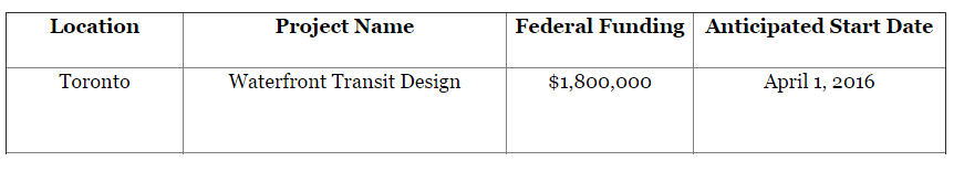
I suspect it's funding for the already underway Waterfront Transit Reset study (note the April 1 date for the federal $$). A further report on this should be coming to Council later in September or October.