Toronto Lower Don Lands Redevelopment | ?m | ?s | Waterfront Toronto

I was holding my breath expecting another slew of denials and 'sunny ways', perhaps even getting banned for a week again...the press has been very remiss on this issue, and many are oblivious to the history of land use there. That might have to change. Perhaps the press and plebs need to be nudged? I'm getting a bit old for that, but I still have a temper. And a few connections left in the media.

44 writes:

This is crucial, as a recurring theme in these instances is often involved agencies *using* their ignorance of unpleasant details to gloss over the issue. (See no evil, etc). I even wonder if there are departments at City Hall trying to get the attention of executive on this, to no avail. It certainly wouldn't be the first time, no need to list even the recent events of that happening. (Judson Street ring a bell?)

44 makes an excellent case of what's being done, and what continues to need be done, and the timeline to do it. And that's just with what's known. We can be assured that there's going to be some nasty surprises, and not just soil.

Something I veered from, and 44 alluded to it, is the *static* contaminants buried, in stasis, albeit in some (many?) cases, inevitably leaching, but Coles raises the point as 44 continues, of ongoing upstream sourcing of pollution. The City itself alludes to these. What's the point of putting on clean socks if you're going to continue stomping through the mud?

Fish and birds have returned to the Don (albeit with caveats), I itemized that earlier in this forum, but the Don continues to be a flowing cesspool. I see it every time I cycle down the Don cycle path, or go past the Keating on my way to the studio on Polson St. There's no way to allow a dog, let alone a child, in that water.

The last major effort to cleanse the *topsoil* was some twenty years ago, basically by cooking out the volatile petro vapours. What remained was still highly contaminated, just not as volatile. And the process of heat treatment killed any valuable microbes that would have digested much of the petro waste over time.

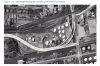
Goldie's pic speaks volumes. What it doesn't show is the *intentional* burying of waste in recent years (as recently as fifteen years ago), albeit illegally, by a disposal company. They were prosecuted, I knew some of those involved in passing (mostly at the restaurants down there, I won't name the company unless I can quote a legal reference). The charges and convictions were criminal.

And the press has gone silent on it since.

The mouth of the Don must be re-aligned, but I'm astounded how some are so ready to talk about building their shiny wondrous bling without even addressing the open sewers running adjacent, and the contaminants dumped there for a century, intentionally or otherwise.

Would you build a house on land that hasn't been assayed first? Then why should the Waterfront be doing it? Again, the Don must be realigned, but without holding coffer dams and ponds, exactly what Coles discusses will happen. And for how long is another very real question to answer. One only has to look at how The Beaches are fed from the Bluffs (and the deposition is now slowing markedly as erosion is stymied along the Bluffs), guess what's going to happen with sediment plumes from the Don once digging begins.

Is it old fashioned still to state: "First things first"? It's almost too long for a Tweet.

It's a worthwhile discussion to engage in, but I do think it's disingenuous to suggest that the officials behind the project are oblivious to these concerns. They've hired some of the world's foremost experts as consultants on various stages of the project and, if memory serves, have built in a substantial buffer (30% is what sticks in my mind) to the budget for the project precisely because they recognize that one really knows what lies beneath until it's revealed and tested.

Really nasty sites have been cleaned up successfully all over the world, and I don't think it's fair to suggest that this project is doomed to fail just because it's big and expensive and complicated.

At the very least, even setting aside the economic development potential for a moment, I'd suggest the massive environmental concerns (including the unknown unknowns) are a really good reason to proceed with exactly such a project, rather than to sit back and continue to let it rot.
A well written post, albeit it incorrectly presumes a number of points made by myself and a few others. I'll do some research later this evening, events permitting, and itemize, but for now:
At the very least, even setting aside the economic development potential for a moment, I'd suggest the massive environmental concerns (including the unknown unknowns) are a really good reason to proceed with exactly such a project, rather than to sit back and continue to let it rot.
The need for a better outflow is not denied by anyone! It's beyond obvious. Flooding is the immediate issue, and it's either deal with the spread of pollutants by that vehicle or the distribution of now nearly static ones the other.

The question is: "How" to realign the outflow. 44 raises a very relevant point on channeling the turbulence of disturbed deposition. Is the projection to just dig and smooth out the new channel walls? Without sealed walls, the banks of polluted sediment will erode out into the lake and further along to wash up on beaches. I can't see how the 'new channel' can work as envisaged...there's the matter of millions of metric tons of deposited toxic waste, much of it water soluble in some forms, and easy to redeposit in other particulate forms. "Settling pools"? Really? The task as promoted may be even worse than incredibly expensive, it may be impossible.

And if Waterfront are so up on knowing what's already there, where are the published reports? Let me guess (and I'm being the Devil's Advocate here): "Not for Public Release". Feel absolutely free to post any you have access to. Yes, that's a challenge! All very easy to say "well they wouldn't do it if they didn't know what they were doing". Gosh, we've never been misled on that before, have we? If they have engineering surveys to back up their claims, then where are they?

I'll do some digging (figuratively) and get back to this forum. I've yet to review what I've gathered from the City's published reports. Might have to go through the backdoor to get some more. I'm sure the province is sitting on some too.

Edit to Add: Just quickly glancing through some covering reports, and I find this interesting:
Lower Don Lands Project
1
STAFF REPORT
ACTION REQUIRED
Lower Don Lands Project
Date: May 31, 2010
To:
Executive Committee
From:
Richard Butts, Deputy City Manager
[...]
RECOMMENDATIONS
It is recommended that Council:
[...]
3.authorize Waterfront Toronto to put the Lower Don Lands Class EA Infrastructure Master Plan (May 2010) in the public record in accordance with the requirements of the Municipal Class Environment Assessment;
[...]
http://www.toronto.ca/legdocs/mmis/2010/ex/bgrd/backgroundfile-30878.pdf

I'll certainly be looking into that...

Second Edit to Add:

This is specifically about the Gardiner extension and area, and tells far more than any of the 'brochures' do:
(Having formatting issues, will find some way to copy and paste this in later)(see post following)
PDF Pg 23-25,
http://www.gardinereast.ca/sites/default/files/documents/Gardiner EA Report - CH 3 Draft.pdf
 
Last edited:
upload_2016-12-4_6-9-24.png

[...]
upload_2016-12-2_20-36-25.png

upload_2016-12-2_20-37-42.png
upload_2016-12-2_20-38-40.png
upload_2016-12-2_20-40-5.png

http://www.gardinereast.ca/sites/default/files/documents/Gardiner EA Report - CH 3 Draft.pdf
upload_2016-12-2_21-24-12.png
 

Attachments

  • upload_2016-12-2_20-36-25.png
    upload_2016-12-2_20-36-25.png
    164 KB · Views: 872
  • upload_2016-12-2_20-37-42.png
    upload_2016-12-2_20-37-42.png
    18 KB · Views: 857
  • upload_2016-12-2_20-38-40.png
    upload_2016-12-2_20-38-40.png
    72.1 KB · Views: 874
  • upload_2016-12-2_20-40-5.png
    upload_2016-12-2_20-40-5.png
    75 KB · Views: 860
  • upload_2016-12-2_21-24-12.png
    upload_2016-12-2_21-24-12.png
    547.6 KB · Views: 866
  • upload_2016-12-4_6-9-24.png
    upload_2016-12-4_6-9-24.png
    61.1 KB · Views: 696
Last edited:
I defer from commenting further on this amount on soil conditions that Waterfront Toronto includes in their 364 page Master Plan. I'm aghast at how they just look the other way...

upload_2016-12-2_22-32-22.png


upload_2016-12-2_22-17-22.png

http://www.waterfrontoronto.ca/uplo...ecinct_esr_main_report___may_2010_23_mb_1.pdf

What you see above is all there is on soil conditions. That's it!

Edit Added Dec 4:
The Waterfront Main Report is 364 pages long. It claims to be an "Environmental Study Report" and is very clear in being completely remiss in mentioning soil conditions other than compaction (which is well known to be that of a sponge other than overlaying patinas in parts).

How incredibly convenient for them, in the face of other findings, including the July 2016 Gardiner EA Report, to at least not link them? If anyone needs proof of 'one hand not knowing what the other is doing'....this is it, *even as the study is theirs partnered with the City of Toronto*.

upload_2016-12-4_5-56-12.png


http://www.gardinereast.ca/sites/default/files/documents/Gardiner EA Report - CH 3 Draft.pdf
 

Attachments

  • upload_2016-12-2_22-17-22.png
    upload_2016-12-2_22-17-22.png
    56.5 KB · Views: 850
  • upload_2016-12-2_22-32-22.png
    upload_2016-12-2_22-32-22.png
    36.2 KB · Views: 845
  • upload_2016-12-4_5-56-12.png
    upload_2016-12-4_5-56-12.png
    38.1 KB · Views: 703
Last edited:
These photos may be helpful:
Incredibly helpful. My stomach sinks viewing them, even as I'm making the point with text...

Two Points to Add:
I noted this from prior aerial pics: There are puddles of spilled petroleum/chemicals within the bermed retention areas around many of the tanks. I noted this practice being prevalent right up until the last tanks at the corner of Cherry and Villiers were decommissioned. I can assure readers that *apparently* there was no sealed membrane to prevent seepage into the underlying strata, the berms merely prevented lateral migration on the surface.

44's observation of the (gist) "black mounds": It is very clear to see the massive stockpiling of coal for the Hearn in the former pic. RE: My observation of (gist) "much of the land north of Cherry Beach is clinker, used as fill or otherwise". It may in fact have been coal detritus. Take your pick of toxin...
 
Last edited:
yyzer, May 9, 2007
But there's still much to be done before construction begins. As Glaisek explained, the winning team will be contracted to work with Toronto Region Conservation Authority to continue through the completion of the environmental assessment process. Assuming all goes well, that should last at least 18 months.

"It's not sexy," Glaisek admitted, "but it's very important. After that the team can start producing final design documents. So we could see the start of construction about 2 1/2 years from now."
: - Christopher Hume
From the TorStar, April 14, 2007

This is in reference to same:
Don Mouth Naturalization and Port Lands Flood Protection Project
Home > Conservation > Green Infrastructure > Don Mouth Naturalization and Port Lands Flood Protection Project
[...]
Environmental Assessment
The configuration of the existing Don Mouth was engineered primarily for the purposes of achieving transportation efficiency and to create additional land for port and other urban uses. This has resulted in the current condition with lands vulnerable to flooding, a serious reduction in ecological function of the river mouth, and an area that is neither aesthetically pleasing, nor available for public use and enjoyment./p>

The naturalization of the Don Mouth will establish a floodplain within the lower reaches of the Don River which will, over the long-term:

  • Improve aquatic and terrestrial ecological functions and provide enhanced linkages to upstream habitats;
  • Address sediment deposition, debris and ice jams;
  • Accommodate changes in precipitation, water flow, and Lake Ontario water levels resulting from climate change;
  • Enhance recreation opportunities and local aesthetics;
  • Provide natural habitat, pedestrian and bicycle trail linkages between Lake Ontario and the Don watershed; and,
  • Manage significant sources of contaminated soil within the Lower Don Lands.
Numerous other permits and approvals will be required under other statutes.

For more information on the DMNP EA please visit Other Recent Updates and here to view past EA activities.
[...]
https://trca.ca/conservation/green-infrastructure/don-mouth-naturalization-port-lands-flood-protection-project/#other recent updates

Oddly, reference to the "2009 Subsurface Investigation report" ( http://www.gardinereast.ca/sites/default/files/documents/Gardiner EA Report - CH 3 Draft.pdf ) is absent, even as "Manage significant sources of contaminated soil within the Lower Don Lands." is stated in the Don Mouth Naturalization and Port Lands Flood Protection Project above.

Still looking for the "2009 Subsurface Investigation report", it's proving to be elusive...

The following is from 2014, and questions on the soil are still ongoing:
pdf reader page 29, http://www.toronto.ca/legdocs/mmis/2012/ex/bgrd/backgroundfile-49719.pdf

upload_2016-12-4_12-17-30.png

[...]
upload_2016-12-4_12-26-14.png

[...]
upload_2016-12-4_12-9-14.png


Edit to Add 5:00PM, Dec 4:
upload_2016-12-4_16-56-42.png

[...]
upload_2016-12-4_17-2-22.png


pdf pg 17, http://www.toronto.ca/legdocs/mmis/2016/ex/bgrd/backgroundfile-97552.pdf

Still can't find actual soil reports. It might take an FOI request...
 

Attachments

  • upload_2016-12-4_12-9-14.png
    upload_2016-12-4_12-9-14.png
    69.6 KB · Views: 594
  • upload_2016-12-4_12-17-30.png
    upload_2016-12-4_12-17-30.png
    23.5 KB · Views: 559
  • upload_2016-12-4_12-26-14.png
    upload_2016-12-4_12-26-14.png
    5 KB · Views: 580
  • upload_2016-12-4_16-56-42.png
    upload_2016-12-4_16-56-42.png
    31.5 KB · Views: 560
  • upload_2016-12-4_17-2-22.png
    upload_2016-12-4_17-2-22.png
    52.1 KB · Views: 580
Last edited:
With some trepidation, I add this to the discourse above. It's not by coincidence that I choose this. Portland's been mentioned many times as a "success story", and Portland has come up many times in mention of the architectural team chosen to design the remediated and reborn dream for the Port Lands.

What is radically different in the case of the US is the establishment of a very pro-active federal environment agency (EPA), ironically by a Republican president. (Edit to clarify: With the exception of President George W. Bush, the Superfund polluter pays fees have benefited from broad bipartisan presidential support. President Jimmy Carter, a Democrat, signed the original law in 1980 and President Ronald Reagan, a Republican, signed the 1986 law to continue collecting the fees.)

Getting back to Portland and the comparison to Toronto and hearty hails of "if they can do it, so can we"....can we?
Portland Harbor Superfund Site


EPA Public Comment Period on the Proposed Plan for Portland Harbor is Closed
The official EPA public comment period on the Proposed Plan for the Portland Harbor Superfund Site is now closed. The Proposed Plan was released on June 8, 2016 and public comments were accepted through September 6, 2016 (90 days). This time period included a 30-day extension required by law, as well as an additional 30-day extension, based on requests for additional time received by EPA.

In addition to accepting comments via e-mail, an online comment form and postal mail, EPA also provided four public meetings. At these public meetings, EPA presented and discussed the preferred cleanup alternative described in the Proposed Plan and accepted oral and written comments on the Proposed Plan. A video of one of the public meeting presentations and the presentation slides from the public meetings are below:

How will EPA respond to comments that were received on the Proposed Plan?
EPA will include responses to all comments that were received during the official public comment period in a responsiveness summary that will accompany the final cleanup plan (also called the Record of Decision). All comments that were submitted to EPA will be available in the Administrative Record upon the release of the final cleanup plan.

What was EPA’s Proposed Cleanup Plan for the Portland Harbor Superfund Site?
The Proposed Plan presented EPA’s preferred cleanup alternative, Alternative I, which reduces risks to human health and the environment to acceptable levels by dredging or capping 291 acres of contaminated sediments and 19,472 lineal feet of contaminated river bank, followed by 23 years of monitored natural recovery. The preferred alternative also includes disposal of dredged sediment in an on-site confined disposal facility and upland landfills. This Alternative will cost approximately $746 million and take 7 years of construction in the river.

The Proposed Plan also described other alternatives that were considered and the criteria EPA used to compare the alternatives, including estimated costs and construction timelines.
[...continues next pane...]
 
Last edited:
Continued from previous post:
Proposed Plan Documents and Resources:
Other Site Documents
Fact sheets...

Proposed Confined Disposal Facility
Enforcement Information
General Notice Letters
- Superfund "General Notice Letters" inform recipients that they are identified as a Potentially Responsible Party and may be liable for cleanup costs at the site.

Linnton Plywood Consent Decree

Smurfit-Stone Container Corporation Settlement

Site Summary
The Portland Harbor Superfund Site in Portland, Oregon is located within the lower Willamette River from the Broadway Bridge (RM 11.8) to Kelly Point Park (RM 1.9) and is the result of decades of industrial use along the Willamette River. The Portland Harbor Superfund Site was added to EPA's National Priorities List in December 2000.

Water and sediment at the Portland Harbor Site are contaminated with many hazardous substances, including polychlorinated biphenyls (PCBs), polycyclic aromatic hydrocarbons (PAHs), dioxins/furans, pesticides and heavy metals. These compounds have been found to be harmful to people and the environment. Health risks at the site are great enough for cleanup to be needed under the Superfund law.

EPA and the Oregon Department of Environmental Quality are working with potentially responsible parties to clean up contaminated sediment and control sources of contamination.
https://yosemite.epa.gov/r10/cleanup.nsf/ph/portland+harbor+superfund+site

What a radical difference in accountability, honesty and access to information...
 
Last edited:
Looks like news is coming down the pipe.

I just read the capital budget (2017) for Waterfront Revitalization.

This year, Essroc Quay + other 'flood protection', totals $75M

But 2018 shows a total of 253M with with 1.2B by 2021.

Of note, these are listed under 'funded' projects.

http://www1.toronto.ca/City Of Toronto/Strategic Communications/City Budget/2017/Analyst Notes/Capital/Waterfront_cap_Dec5_1738.pdf
Good heads-up. Haven't had time to read it, just started scanning, and this is a curious point:
State of
Good Repair Backlog
A backlog for State of Good Repair work does not exist for Waterfront Revitalization Initiative since the Program has
no inventory of capital assets. Any capital assets that Waterfront Revitalization may create, is maintained by other
City programs including Transportation; Parks, Forestry and Recreation; Toronto Water; and Solid Waste
Management.
Odd...

The Essroc Quay: I read constant reference to (gist) "the need to strengthen the pier structure to withstand flooding"....which I haven't found an explanation for. There may be one, I've read a lot of reports on it, and yet I've yet to find an explanation, only the intent to fill the slip. And that's specifically named in this report. Very curious...it's withstood floods all this time, and is to be rendered unconnected to Don flow save for flood overflow. There's something else going on there...

Edit to Add:

Here's a typical description re Essroc Quay:
Essroc Quay is a self-contained project that will improve storm water management at the mouth of the Don River. While integral to the overall flood protection plan, the Essroc Quay project can be implemented in advance of the larger scope of work.

Infilling Essroc Quay will also lead to improvements in water quality and create new naturalized open spaces and aquatic habitat.
http://www.toronto.ca/legdocs/mmis/2016/ex/bgrd/backgroundfile-97552.pdf

Curious....For a start, how can "infilling" "create a "new... aquatic habitat"? I see that claim repeated often in reports. And no-one questions it...
 
Last edited:
Looks like news is coming down the pipe.

I just read the capital budget (2017) for Waterfront Revitalization.

This year, Essroc Quay + other 'flood protection', totals $75M

But 2018 shows a total of 253M with with 1.2B by 2021.

Of note, these are listed under 'funded' projects.

http://www1.toronto.ca/City Of Toronto/Strategic Communications/City Budget/2017/Analyst Notes/Capital/Waterfront_cap_Dec5_1738.pdf


See: http://www.waterfrontoronto.ca/uplo...on_project_update_11_30_16_consolidated_1.pdf
 
Here's a typical description re Essroc Quay:

http://www.toronto.ca/legdocs/mmis/2016/ex/bgrd/backgroundfile-97552.pdf

Curious....For a start, how can "infilling" "create a "new... aquatic habitat"? I see that claim repeated often in reports. And no-one questions it...

Of course you can - instead of vertical dockwalls, you can have armored stones and other treatments that facilitates the creation of new habitat. This kind of thing has been done elsewhere along the waterfront - you don't have to retort to conspiracy theories for it. It is also no secret that a good amount of dockwalls along the waterfront is in poor position - I think the work around Jarvis and Portland slip required significant dockwall repairs - and it's been noted that the Shipping Channel may require the same - in fact placing armour stones was suggested as a way to deal with the issue in the discussion.

AoD
 
Last edited:
Of course you can - instead of vertical dockwalls, you can have armored stones and other treatments that facilitates the creation of new habitat. This kind of thing has been done elsewhere along the waterfront - you don't have to retort to conspiracy theories for it. It is also no secret that a good amount of dockwalls along the waterfront is in poor position - I think the work around Jarvis and Portland slip required significant dockwall repairs - and it's been noted that the Shipping Channel may require the same - in fact placing armour stones was suggested as a way to deal with the issue in the discussion.

AoD
So can you supply a reference to that being the case? And how this is being projected to happen?

Here's the best reference I can find on it:
https://www1.toronto.ca/City Of Tor...sroc Quay CWWF project backgrounder FINAL.pdf

It does mention the risk of the wall collapsing.
 

Back
Top