Automation Gallery
Superstar
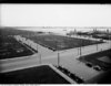
There's no streetcar platform being built. There's updated drawings on the City site from Sept 29th.
Hmm?, i thought it was always in the plan to have the streetcar go through there
There's no streetcar platform being built. There's updated drawings on the City site from Sept 29th.
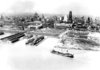
The good old days of dumping your spare ties into the lake. HeheI assume that's a pile of railroad ties (sleepers in UK-talk). It really seems you can't excavate anywhere south of Front without finding them.
Thanks for your weekly updates!
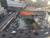
View attachment 127494
Or, more likely, there were rail lines ON the land and when the berm was built they were not usable so they removed the rails but left the ties. Only way to really know would be to see if they are lying in a pile or are arranged like a railway. From the 1913 Goads it looks as though there were many rail sidings in that area.I'm wondering how the ties got there. It's possible that they were combined with fill when the land was reclaimed from the lake. Or the railways that used the reclaimed land buried them to get rid of them.
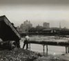


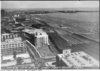

Interesting too to see that the Dominion Public Building was built in 2 phases - not surprising, but interesting!I always knew that the Toronto Harbour Commission Building used to be at the edge of the lake. But that fourth-to-last photo really brings home how far the land has been extended into the lake. Wow!!
Dear neighbours,
On October 24th, the Southcore Community Association hosted a public meeting on the project, which allowed us the opportunity to present the project and to hear feedback from the community. As part of that meeting, we committed to providing updates on our progress.
Since this meeting, EllisDon, our General Contractor, has completed the installation of a structure along Bay Street that will serve as a temporary material drop-off in order to keep construction activity out of Bay Street, so as not to impede local traffic.
EllisDon continues the installation of the retention system tie-backs on the south, west and north sides of the excavation and the removal of soil and rock material. This excavation must be completed by mid-January of next year. To complete this work on schedule, we anticipate the need to work extended hours from December 1st to January 19th. Upon approval from the City, we expect to work until 10 pm Monday to Friday (excluding statutory holidays) during this limited period.
The installation of three tower cranes should begin in January of next year. The first crane will be close to the southwest corner, the second one near the northwest corner and the third one further to the east near the middle of the site.
Excavation and drilling for the foundations to support the future overbuild park above the rail corridor should begin at the end of November and continue until the middle of February of next year. This work will occur outside of the normal train operating hours, and in coordination with work done by others in the rail corridor.
A community information website on the CIBC Square project will be available to you soon. You will be able to refer to this site for future construction and project updates. We will notify you when the site is online.
We appreciate your interest in the CIBC Square project and look forward to participating in the development of the SouthCore community.