


W. K. Lis
Superstar
Suburban sprawl is an irresistible force in Canada too. For example:
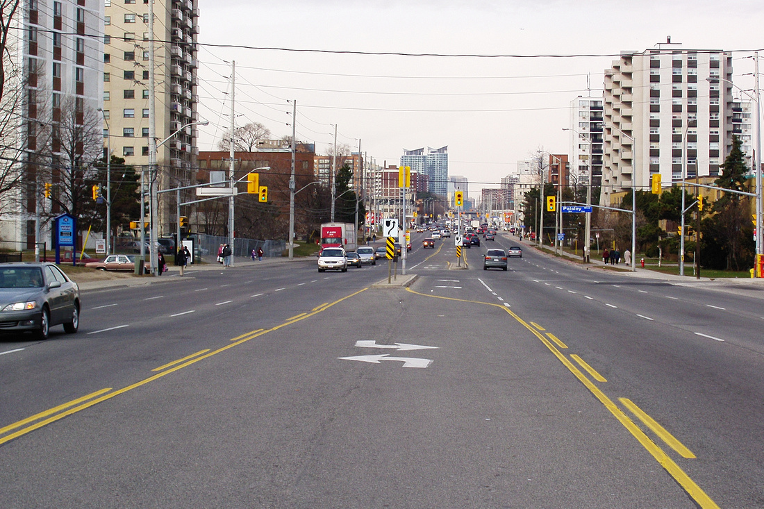
Three lanes in each direction, plus left turn reserved right-of-ways in the middle, make up sprawl. Not very friendly to pedestrians.
|
|
|
Suburban sprawl is an irresistible force in Canada too. For example:
Three lanes in each direction, plus left turn reserved right-of-ways in the middle, make up sprawl. Not very friendly to pedestrians.
Three lanes in each direction, plus left turn reserved right-of-ways in the middle, make up sprawl. Not very friendly to pedestrians.
It's a suburban street to be sure, but the built form in the photo is entirely high density development--there is no sprawl as far as the eye can see. Some of it is towers in the park, but the green space is quite limited. Imagine replacing the housing in those buildings, especially the high-rise apartments, with the standard detached homes you see in Mississauga. You would need dozens of city blocks to house the people in those buildings. That's sprawl. Apartment buildings will generally only constitute sprawl if their density is watered down by large green spaces and parking lots, as you often see in suburban Toronto.
8 Monster Interchanges That Blight American Cities
by Angie Schmitt
Ramming highways through the middle of American cities was undoubtedly one of the worst mistakes of the 20th century — demolishing urban habitat, dividing neighborhoods, and erecting structures that suck the life out of places. What could be worse than a highway through the middle of town? How about when two highways intersect, with all their assorted high-speed ramps carving out huge chunks of land to move cars.
But despite their massive scale and the huge sums we spend on them, highway interchanges in American cities can seem invisible. After all, no one ever goes to hang out by the interchange.
So, to give you a good look, we put together this list of some of the most enormous interchanges in U.S. cities. Just imagine what cities could do with all this space…
Louisville: Kennedy Interchange (64/65/71)
Photo: Patrick Smith
Louisville’s Kennedy Interchange sits just north of downtown, forming an immense barrier to the city’s waterfront. Gigantic as it may be, this interchange will be getting even bigger as Kentucky and Indiana move forward with the $2.6 billion Ohio River Bridges project. Even the New York Times lamented the effect of this highway expansion on downtown neighborhoods. But when Louisville activists argued that a portion of the roadway feeding into the interchange should be torn down, they were steamrolled by powerful political interests.
Milwaukee: Marquette Interchange (94/43/794)
Rebuilding and expanding Milwaukee’s Marquette Interchange, located not far from downtown Milwaukee by Marquette University, cost $810 million to complete in 2008. It took 2.25 million man hours to construct the 28 ramps and 21 miles of roadway. The concrete and steel needed to complete the project weighed 60,000 tons, according to the Milwaukee Journal Sentinel.
To 1000 Friends of Wisconsin, this interchange expansion was a “billion dollar blunder.†Meanwhile, the Federal Highway Administration gave the project its “Award of Excellence in Highway Design.†Wisconsin is currently preparing for an even bigger interchange project: the $1.7 billion “Zoo Interchange,†not far away.
Los Angeles: Pregerson Interchange (110/105)
Photo: Citydata
LA’s Pregerson Interchange was completed in 1993 at a cost of $135 million. At the time it was the most expensive “traffic structure†Caltrans had ever built. The LA Times called it a “five-level maze of soaring and curving freeway lanes.†It includes nine miles of cloverleaf loops and is a mile and a half wide, a gargantuan pile of concrete looming over some of the city’s poorest neighborhoods.
San Diego: I-5 and CA-163

This interchange in San Diego is mostly tragic for its location, just on the border of Balboa Park, San Diego’s “crown jewel,†according to BikeSD’s Sam Ollinger. Despite the near constant congestion, the interchange is at least scenic, drivers say. But good luck getting to the Art and Space Museum on foot from downtown.
Columbus: I-670 and I-71
The intersection of I-670 and I-71 in Columbus completely isolates part of the city bordering downtown and Columbus State Community College. Within the tangle of ramps is a school for the arts and a parking facility for Columbus Public School buses.
Construction to expand to the interchange began in 2011. The $200 million project includes the construction of 22 bridges, plus a “cultural wall designed with community input.†The project is part of a larger, $556 million rebuilding of three major interchanges by downtown. “It’s a once-in-a-lifetime project,†an ODOT official told the local business publication.
Image: DLZ.com
Detroit: I-375 and I-75
Streetsblog showed the damage done to east Detroit by I-375 in this compelling series of photos. This whole area was once a densely populated neighborhood of walkable blocks, home to much of the city’s African-American population. Downtown Detroit is completely surrounded by highways, forming a noose around the city. This interchange separates downtown Detroit from the Eastern Market, a major regional attraction.
The good news is there has been talk in Detroit of tearing out I-375. The road needs expensive repairs and the least costly option is being considered: replacing it with a pedestrian-friendly parkway.
Seattle: I-90 and I-5
Photo: Longbachnguyen
Just outside downtown Seattle, the I-90/I-5 Interchange is a tangled mass of traffic. More than 1,600 people have “checked-in†at this location on Foursquare. “This sucks,†says one. “Nice shrub on the southbound side,†says another.
Seattle’s anti-highway activists halted a freeway expansion here in the 1970s, leaving behind “ramps to nowhere†that had been built in anticipation of future road construction. Some of those ramps were eventually incorporated into this interchange.
Chicago: Circle Interchange (90/94/290)
Photo: Wikipedia
This circular interchange merges the Dan Ryan, Kennedy, and Eisenhower expressways, just west of Chicago’s Loop. The Blue Line’s L train tracks pass under the interchange.
Constructed in the late 1950s and early 1960s, the Circle Interchange will be rebuilt and expanded in a $400 million project that the Illinois Department of Transportation recently rammed through, even though it never made the regional planning agency’s list of high priorities.

Book Review: 'Robert Moses: Master Builder of New York City'
Graphic novel retells tale of America’s greatest dictator-planner.

Nobrow (US) Inc. / The legacies of Robert Moses and Jane Jacobs face off in a new graphic novel.
On the two most towering figures in 20th century American urbanism, arch rivals Robert Moses and Jane Jacobs, plenty of words have been written. Jacobs' were mostly by her own hand. Moses, the more monumental if enigmatic figure, was too busy building to do much writing. His legacy belongs largely to Robert Caro, who wrote 1,344 pages about him.

Does the world need yet another account of Moses' crusade to build the 20th century's greatest city (and Jacobs' efforts to save its soul)? It does, perhaps, when that book is Pierre Christin’s and Oliver Balez’s engaging, unexpected graphic novel Robert Moses: The Master Builder of New York City.
If nothing else, Robert Moses was larger than life. In wresting control of city commissions and building some of the city's greatest parks, bridges, and housing projects seemingly singlehandedly, he could almost be considered a superhero. Or supervillan, depending your point of view. As a close cousin of the comic book, the graphic novel is well suited to illustrate, literally, Moses' powers.
With the exception of a few flash forwards, Robert Moses traces his life from childhood to lonely sunset. Young Robert had more than a few chips on his shoulder, and more than a few lessons to learn, as the scion of a wealthy Jewish family. He witnessed the depredation of Manhattan's tenements and suffered the taunts of anti-Semites, particularly at Yale. He learned to revile the era's robber barons and pity the city's poor.
Out of college, Moses meets his future wife, to whom he is not, the story suggests, always faithful, and he meets Mrs. Moskovitz, a wealthy, well connected matron who launches Moses' political career. In short order, Moses distinguishes himself in the Gov. Alfred E. Smith administration, dreams of building New York City, and gets himself appointed head of the state-administered Parks Commission. The rest is (well documented) history: fueled by a seemingly psychotic desire to build and buoyed by supreme confidence, Moses served in executive positions, sometimes in 12 simultaneously, from 1924 to 1968.

Naturally, Robert Moses does not claim to be an historical document. Caro already did that heavy lifting. The book is, however, a human portrait of a hardened man and a stirring rendering of his works. Needless to say, a picture book suits tales of urban planning well. We see the Maritime Theater, the George Washington Bridge, the Cross-Bronx Expressway, and the United Nations headquarters—among dozens of his other projects reverently rendered. We see them rise as the cartoon Moses himself looks on with self-pride. We see pathos as he overlooks the scale model of New York that he commissioned for the unsuccessful 1963 World's Fair.
It's an odd feeling to see a historical figure represented visually, with his carriage, mannerisms, and emotions on display, often, in Moses’ case, with a beatific look of self-satisfaction. Moses is routinely portrayed as an imposing figure, looming over his colleagues and issuing orders never to be disobeyed. That much is believable, given what Moses accomplished. More troublesome is the dialog. Much of it is didactic, with Moses giving tours of the city to explain what he’s building. Some of it is romantic, as when he's flirting with showgirls.
At one point, Moses is compared explicitly to Batman. It's a jarring, campy moment. Then again, Moses could do worse. Batman is the most complex figure in the Justice League, and the most urban.

And what could be better suited to a graphic novel than images of a city? Balez, the illustrator, renders New York in an appealing palette of browns, ochres, grays, and tans, punctuated by blazes of deep orange. Meanwhile, fashions evolve along with Moses' career, right up to the point whenhis passers-by appropriately look like extras from Mad Men, heading to Moses' Lincoln Center after a long day at Sterling Cooper, and then over his Triborough Bridge (whosetolls funded much of his work) to their homes near Rockaway Park, which Moses developed. In its most joyous sequence, we meet Jane Jacobs for the first time. She is, in a quartet of panels, riding a bicycle through various scenes of classic New York. In each, she is in the same position, facing the same direction, with the same beatific expression on her face. The human-scale ballet of the city takes place around her. She appreciates it in ways that the Master Builder never could. She takes on Moses over the proposed Lower Manhattan Expressway and the extension of Fifth Avenue. We know how those battles turned out.
But those defeats led to a cascade of rebukes and demotions as Moses finally proved vulnerable and politicians caught on to other ideas. New York may have been Moses' city for most of the 20th century. These days, though, we are living in Jane Jacobs' world. In the end, the pictures and speech bubbles of Robert Moses ask, who is the real hero: the builder, or the writer?
That's because it's a road. It's not supposed to be friendly to pedestrians. That's like looking at the sidewalk and suggesting it's not friendly for vehicles.Three lanes in each direction, plus left turn reserved right-of-ways in the middle, make up sprawl. Not very friendly to pedestrians.
The article itself defined the US-style sprawl as "Sprawl, defined as the unplanned, uncontrolled expansion of urban areas beyond their fringes".One definition I like that I read about sprawl is the outward expansion of an urban area that results in the decline in the overall density of that urban area. If the an urban area expands outward but the density stays the same or increases, that would not be sprawl.
It may have been organic and unplanned, but in a pre-automobile world, leading to natural constraints. There was quite stringent green-belt and planning legislation in the 1940s, if not earlier, long before automobiles became ever dominant in the UK.To define sprawl as unplanned would mean that most of London (UK) is sprawl too since it mostly grew organically, no planning.
The article itself defined the US-style sprawl as "Sprawl, defined as the unplanned, uncontrolled expansion of urban areas beyond their fringes".
We might call Mississauga "sprawl" But it was neither unplanned nor uncontrolled. Compare to the USA, where you can be driving though farm country in the Atlantic states, miles from anything, and suddenly encounter a farm field turned into cheap housing, with no planning whatsoever.
I've never seen the kind of "sprawl" you see in the USA, around here. Even the pre-Green Belt planning in Ontario was far advanced on what exists (or doesn't exist) in parts of the USA.
Here is an example of bottom-up legislation in the United States:The main reason for this difference is that since the USA is theoretically a bottom-up democracy local municipalities have certain legal rights that are on par or supersede states rights. In many states the state government can't force amalgamation or tell local governments what to do, so if a local government want to allow nothing but +4,000 sq.ft. homes there is little the state can do. Canada, on the other hand, is a top-down democracy, where local municipalities only exist because the Provincial government says they can. If the Province wants to force an amalgamation or tell local governments what to do they can without any local consent. Since the 1950's the Province of Ontario has taken an active role in urban planning, sometime for the worse, but usually for the better.


