News   Apr 19, 2024
 169     0 
News   Apr 19, 2024
 485     2 
News   Apr 19, 2024
 833     3 

Re-routing rail away from Don River -- what can be done to open up Don River Valley Park?

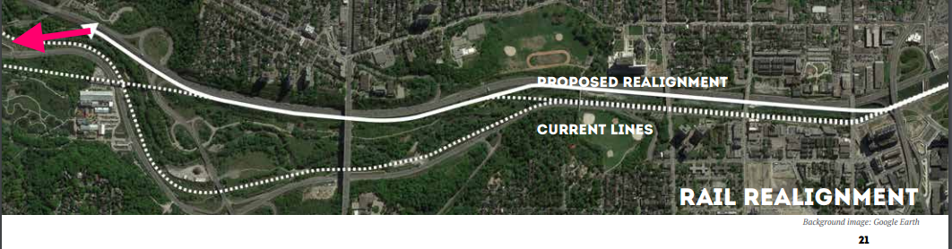
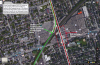
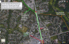
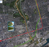
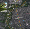
They are not eliminating the DVP exit to Bloor, but it's not clear in the report where the new one will be. My guess is they are removing the cloverleaf and putting the exit from the DVP just a bit above Brickworks closer to Pottery Road. This is where the DVP and Bayview are closest together.

Only if they actually showed the full project as part of their pretty pdf presentation that only lists the benefits and does not address any of the red flags.

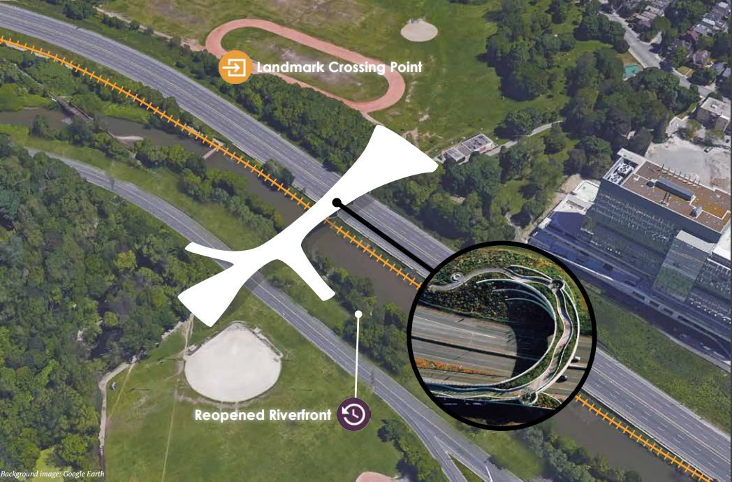
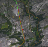
How much are they budgeting for these off-ramps? With this tight space (Todmorden Mills is just east of the DVP there and the river is just west) you would need fly-overs for off-ramps. Probably $200M+ just for this reconfiguration.
 
Yeah, I agree, the report would be better received if it contained some hardnosed discussion of constraints, limitations, and challenges. Hopefully that will be forthcoming.

Here is the "SuperPark" twitter feed giving some more information from the presentation last night (I wasn't there) --

https://twitter.com/hashtag/SuperPark

I also found this nice flyover of the area on youtube:

 
Last edited:
One thing I don't understand is the map on page 21. I get that the idea is to consolidate and re-route the GO Richmond Hill Line and the former CP Don Branch (Belleville Sub). What I do get is how they propose to reconnect the Richmond Hill line back to the existing track in the north. I've done a quick drawing to show where I think it could go to reconnect (see the pink line). Was this covered in the report?

I'm noticing on twitter that Steve Munro is saying that Metrolinx only found out about this idea list week. Sounds like some of the project authors are debating that point. See the twitter debate here.

track-plan.png


Also, I'm noticing on pages 32 and 35 that the idea is to shift the GO Richmond Hill line (and former CP Don Branch) from the west side of the river to the east side, right beside the DVP. Wouldn't that involve creating a new riverbank to support the tracks and narrowing the river? How feasible is that? Or would the additional marshes absorb additional water and reduce the risk of flooding?

south-track-plan.png


fyi...is not removing the cloverleaf...from the pdf it's a complete removal of the DVP on/off ramps (page 20 for a diagram...green roads mean removing them)

http://www.ryerson.ca/content/dam/surp/news/news/General_Public/FINAL DRAFT_PEOPLES PLAN.pdf

From the initial read I thought is was just eliminating the cloverleaf and creating an intersection. But its creating a 8 km stretch of the DVP without an off-ramp. Great in case of accidents we can just trap 8 km of cars on a road for hours.

Brillance! We'll divert traffic through a residential neighbourhood along Don Mills and O'Connor instead
 
Wouldn't that involve creating a new riverbank to support the tracks and narrowing the river?

I wonder about that too. It isn't clear in the report, which seems weak on transportation and engineering analysis. I was thinking that 2-3 new lanes could be created on the east side of the DVP, then the highway shifted on the stretch from Wellesley to Queen (a big undertaking, requiring cutting into the hill and modifying the bridges), allowing the double tracks to be laid where two of the southbound DVP lanes are now.

Others on this thread have suggested removing rail from the riverbed, and interlining this RH line with a yet-to-be-announced DRL to Eglinton/Donlands.

In the least, it has people talking about all the complex engineering and cost issues of reclaiming the Don river with an integrated park while keeping the trains and cars moving.
 
One thing I don't understand is the map on page 21. I get that the idea is to consolidate and re-route the GO Richmond Hill Line and the former CP Don Branch (Belleville Sub). What I do get is how they propose to reconnect the Richmond Hill line back to the existing track in the north. I've done a quick drawing to show where I think it could go to reconnect (see the pink line). Was this covered in the report?

I'm noticing on twitter that Steve Munro is saying that Metrolinx only found out about this idea list week. Sounds like some of the project authors are debating that point. See the twitter debate here.

track-plan.png


Also, I'm noticing on pages 32 and 35 that the idea is to shift the GO Richmond Hill line (and former CP Don Branch) from the west side of the river to the east side, right beside the DVP. Wouldn't that involve creating a new riverbank to support the tracks and narrowing the river? How feasible is that? Or would the additional marshes absorb additional water and reduce the risk of flooding?

south-track-plan.png

These were exactly my points. I think it begs the question of what new environmental impacts that would create.
 
In the least, it has people talking about all the complex engineering and cost issues of reclaiming the Don river with an integrated park while keeping the trains and cars moving.

Exactly. There are many things we can pick apart about these "plans" (whether it be with rail lines, highways, etc). But really this isn't even a plan yet. It's a vision, one several generations in the making, and an extremely laudable one that should be started ASAP. I was at the meeting, and specifics of this vision weren't even part of the discussion. This is really more about gaining momentum, getting the public and their ideas on board, then I guess trying to piece together the parts and parties involved (i.e City, TTC, Mlinx, GO, hydro, gas, TRCA, Prov, Feds, etc). No easy feat, but the same was said about other city's major attempts at reclaiming land for greenspace.

In the meantime, I'd say the public can still go rogue and try and help our ravine system on their own. I dig up a lot of small trees whenever I'm up north, sometimes I give some away to friends, attempt bonsai, or replant them elsewhere. But with the talk on the previous page about noise barriers and re-greening, I'll probably start plonking some of these white pines and spruces alongside the DVP whenever I make a trek through the valley. A few pockets of evergreens here and there can definitely cut down on the noise and visual pollution of the Lower Don's less attractive uses.
 
I'm definitely on-board with the vision and building momentum.

A few pockets of evergreens here and there can definitely cut down on the noise and visual pollution of the Lower Don's less attractive uses

Great idea, and trees will cut down visual pollution, but will do little to block the road noise unfortunately. Walls with substantial mass are needed to absorb the noise from the DVP traffic. They can be designed to look like rock, and can accommodate ivy.
 

Attachments

  • dc386ea73d93dcf97226cd53716db043.jpg
    dc386ea73d93dcf97226cd53716db043.jpg
    21.2 KB · Views: 208
  • concrete noise barrier with planting bays.jpg
    concrete noise barrier with planting bays.jpg
    31.7 KB · Views: 278
  • 16599239-environmental-noise-barriers1.jpg
    16599239-environmental-noise-barriers1.jpg
    44.5 KB · Views: 257
  • crib_03-14518AD571B1448DE44.jpg
    crib_03-14518AD571B1448DE44.jpg
    65.4 KB · Views: 226
Last edited:
The former CN line doesn't just carry GO trains - it takes the southbound Canadian three times a week too. It used to take it northbound until train lengths exceeded the ability to turn the train after maintenance, now it goes up the Barrie line and reverses onto the CN York to get to the CN Bala Sub. There are ways that this and the other issues noted above could be fixed but no cheap or easy ones.
 
In the meantime, I'd say the public can still go rogue and try and help our ravine system on their own. I dig up a lot of small trees whenever I'm up north, sometimes I give some away to friends, attempt bonsai, or replant them elsewhere. But with the talk on the previous page about noise barriers and re-greening, I'll probably start plonking some of these white pines and spruces alongside the DVP whenever I make a trek through the valley. A few pockets of evergreens here and there can definitely cut down on the noise and visual pollution of the Lower Don's less attractive uses.

I don't know about going 'rogue'. There is lots of planting occurring in the valley, where feasible.

That said, white pine will die if you put anywhere near a busy roadside, as it doesn't care for the steady salt diet.

White spruce on the other hand, probably wouldn't mind.

Neither species cares for wet feet.
 
I wonder about that too. It isn't clear in the report, which seems weak on transportation and engineering analysis. I was thinking that 2-3 new lanes could be created on the east side of the DVP, then the highway shifted on the stretch from Wellesley to Queen (a big undertaking, requiring cutting into the hill and modifying the bridges), allowing the double tracks to be laid where two of the southbound DVP lanes are now.

Others on this thread have suggested removing rail from the riverbed, and interlining this RH line with a yet-to-be-announced DRL to Eglinton/Donlands.

In the least, it has people talking about all the complex engineering and cost issues of reclaiming the Don river with an integrated park while keeping the trains and cars moving.

I'm going to careful what I say............

Lets just say I have a well placed source about such things.

The 'vision' is very 'Blue Sky'.

It has not been subject to even preliminary engineering.

Nothing south of Gerrard could be described as seriously 'on the table' at this time.

Not to say that might not change, but its rather unlikely, in the near term.

I previously noted the more do-able parts, and there is largely consensus around these.

However there is no serious plan, as yet, to do any of them, except remove the City depot, which has been examined in somewhat greater detail.

Even that, however, is neither funded nor approved, as of this writing.

There will, however, be some enhancements to Bayview this year.
 
I found the following 13 slide presentation for the three-phase Lower Don Valley Access Improvements project --

http://www.slideshare.net/TorontoPCU/lower-don-valley-trail-2015-construction

It's good to see these improvements.

Although it is clearly a long way off and "blue sky" thinking right now, I hope that some day the rail can be removed from the Don valley entirely (interlining the GO RH with the DRL, and redirecting the few other trains using the corridor) and modern sound barriers put on the west side of the DVP (cutting noise in half or more). Since electrification of the Richmond Hill line isn't likely to happen in the next 15 years, and the DRL is still probably that far off as well, there is time for designers and stakeholders to work something out that is bold. This forum is a good place to contemplate these possibilities.

499300945.jpg
 

Attachments

  • 499300945.jpg
    499300945.jpg
    437.6 KB · Views: 659
Last edited:
Where does this theory if interlining the Richmond Hill and Relief Line keep coming from? What are we talking about here?

The Relief Line is a heavy subway rail line. The Richmond Hill line is GO trains. Are we proposing converting one or the other? If they are to be two different services in parallel, who is going to pay for a GO tunnel beneath Queen Street? Metrolinx ruled this out a long time ago.

I'm only left with the conclusion that it is fantasy.
 
Under my DRL plan, the RH line would interline with it as the tunnel would support EMU DD trains up to 12 cars long. The tunnel would be 3 tracks to allow express service.

The DRL could interline with trains from the west also.

All stations south of the RH interline point would have stations to handle 12 car trains and 10 cars north of the interline point.

It was something drum118 mentioned above, and a couple other posters also referred to. My interpretation -- GO Richmond Hill would still depart from Union, but would begin to interline with the DRL around Gerrard Square (a junction would be built into the station there). The interlining would continue via tunnel (three tracks) all the way up to Don Mills, just north of Lawrence, where the GO train would emerge from the tunnel onto the existing tracks to Richmond Hill. The routing would make it unnecessary to re-activate the Leaside Spur. The train tunnel would cross the Don Valley via a new bridge built alongside the Millwood Rd bridge. The station at Eglinton/Don Mills would include direct transfer to the Eglinton Crosstown line.

Perhaps something like this? --
Gerrard Sq DRL GO RH junction scheme.png
Don Mills DRL GO RH Line junction.png
lake shore to danforth big map.png
danforth to thorncliffe.png
thorncliffe to lawrence big map.png
 

Attachments

  • Gerrard Sq DRL GO RH junction scheme.png
    Gerrard Sq DRL GO RH junction scheme.png
    2.8 MB · Views: 893
  • Don Mills DRL GO RH Line junction.png
    Don Mills DRL GO RH Line junction.png
    2.8 MB · Views: 904
  • lake shore to danforth big map.png
    lake shore to danforth big map.png
    2 MB · Views: 867
  • danforth to thorncliffe.png
    danforth to thorncliffe.png
    2 MB · Views: 820
  • thorncliffe to lawrence big map.png
    thorncliffe to lawrence big map.png
    2 MB · Views: 823
Last edited:

Back
Top