News   Apr 26, 2024
 1K     3 
News   Apr 26, 2024
 288     0 
News   Apr 26, 2024
 813     0 

King Street (Streetcar Transit Priority)

The claim that a subway would be needed to handle the load should be the last thing to be considered, at least along that alignment.

This is central King St in TO and San Diego's central LRT corridor + transit mall (E-W along the centre of the image), both shown at the same elevation. There's very clearly a stark difference. If we're to go global and choose any other city with a central transit mall, I believe it's safe to say there'd be a stark difference with King as well. Not saying we shouldn't have a transit mall, but it's very clear that a grade-separated transit solution is needed through the core. Toronto planners deduced this a century ago, and numerous times since then. This isn't the boonies, this isn't the 905, this isn't the former boroughs, nor is this a quaint old style downtown... It's the centre of the 4th largest city on the continent and a leading global financial hub. The current and proposed densities blow San Diego and numerous other surface streetcar/LRT cities out of the water many times over.

If we are silly enough to not build a new E-W subway across the core, then any streetcar/LRT solution must be grade separated through the core. Nothing else will work. And not in the plannertician sense that gets suburban subways built, I mean literally. Again, this was deduced many times since the early half of the 20th C.
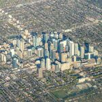
downtown-SD.jpg


downtown-TO.jpg
 

Attachments

  • downtown-TO.jpg
    downtown-TO.jpg
    137.6 KB · Views: 1,061
  • downtown-SD.jpg
    downtown-SD.jpg
    168.1 KB · Views: 1,050
If we increase the velocity of those Flexities, adding length won't be necessary.

- Paul
Been thinking on this, and if King becomes a rush-hour dedicated transit-only mall/clearway, how to maximize throughput:

King Street could host either three or four tracks, two of which are locals, which are closest to the curb each side, for entraining/detraining passengers between express stops at major junctions. The centre track or centre two tracks is/are express tracks. Centre single track express would run the direction of rush hour to or from the core. During off-peak, motor-vehicles can use the express lane(s) when express streetcars not running. Parking, if allowed, might determine which two tracks become the local stopping ones outside of rush-hour when street returns to mixed vehicle/streetcar use.

In effect, rush hour load carried would be more than doubled for each direction an express track is used along with a local track. Various track schemes could be used to deal with the present intersecting streetcar junctions, one of them being that the express track(s) merge(s) with the local tracks before the intersection to use the present track junctions. A centre Y before the junctions would also allow the beginning/end of the direction of the rush hour express if a single third bi-directional track is used. Think Jarvis street when it was five lanes and the centre lane being reversible for rush hour traffic. It might be easiest where room permits to just add a local track in the curb lane each side of King that diverges/merges with the present tracks between present streetcar intersections (Spadina, Bathurst, etc) to get across the present intersection rail junctions w/o replacing them, and to allow the choice of where express and local begin/end.

Discussion of quadruple tracking here:
https://www.quora.com/Other-than-th...-track-main-lines-to-provide-express-services

North America
In North America, the creation of pedestrian-friendly urban environments is still in its infancy, but transit malls have existed in a few cities for more than 40 years, starting with the Nicollet Mall[1] in Minneapolis, Minnesota in 1968, followed by the Granville Mall in Vancouver, British Columbia, in 1974 and the Portland Mall in 1977. In North America, transit malls usually take the form of single streets in which automobiles are mostly prohibited but transit vehicles are allowed. They are rarely completely free of motor vehicles. Often, all of the cross streets are open to motorized traffic, and in some cases taxis are allowed and truck deliveries are made by night.

Examples include:

Here's Melbourne, population approximating Toronto, considered by many surveys to be the best place in the world to live:

maxresdefault.jpg


Thursday, August 2, 2007
12 Comments
Melbourne, Australia After a Decade of Focus on Public Spaces
by Ethan Kent

Melbourne_Australia_skyline_ek_jul07.jpg


With apologies for my carbon footprint, I recently returned from a working tour of eight cities Down Under. The trip included an invitation to Melbourne to work with the staff of the city's successful new public space development, Federation Square, and to help lead a Placemaking training course that included many city staff, local developers and "place managers." In the process, I had the opportunity to learn a few things relevant to my hometown, New York City.

Melbourne's central business district is as dense and urban as any U.S. city other than New York. Like New York City, Melbourne—the fastest growing city in Australia, with a population of nearly 4 million—has a lively public life. But it hasn't always been so. A “New World” city, designed on a grid, Melbourne went as far, or further, than its U.S. counterparts in planning itself around the automobile.

In 1993, Jan Gehl, who happens to be in New York City this week to start work with Department of Transportation, ran one of his “public spaces, public life” surveys in Melbourne. During that first Melbourne study Gehl collected baseline data on how public spaces were being used and made recommendations for improvements. He worked with the city to implement some of these improvements and in 2004 Gehl's team was invited back to do a second study. They found that dramatic changes had taken place during the decade between the studies.

Melbourne_Australia_tram_street_ek_jul07.jpg

Street space in Melbourne's central business district has been taken away from private automobiles and reallocated to transit riders and pedestrians.

Gehl’s studies makes Melbourne one of the few cities in the world where accurate data on public life has been collected over such a period of time. Between 1993 and 2004, these were some of the changes that Gehl's team observed:

  • 71% more space for people and activities on streets and squares
  • 177% more café seats
  • 39% increase in pedestrian activity during the day on weekdays
  • 98% increase in pedestrian activity in the evenings on weekdays
  • Large increases in stationary activity that came with the newly created space

[...continues at length...]
http://usa.streetsblog.org/2007/08/02/melbourne-australia-a-model-for-new-york-city/

Edit to Add: From the reader comments to above article:
[George Haikalis • 9 years ago
  • Melbourne and Toronto have extensive grids of street railways in addition to subways and commuter rail lines. In NY, vision42 -- IRUM's proposal for an auto-free light rail boulevard for 42nd Street -- could serve as a model for an extensive grid of light rail lines, many set in auto-free streets in Manhattan, and elsewhere in NYC. Surface rail transit makes a big difference in the attractiveness of dense places.

    George Haikalis
    President
    Institute for Rational Urban Mobility, Inc. (IRUM) ]
Here's high-quality video of a full route run of a Melbourne 'tram' running down the main business district transit mall: (starting 20 mins in)

And a four track section of the Brussels trams:
 
Last edited:
The King ROW and the DRL should be "and" projects, not "or" projects. Let the DRL carry the Queen-and-up downtown-bound traffic, and let King carry the King-and-down downtown-bound traffic.

Partially reconfigure the streetcar network to resemble what was proposed in the 1950s with the Queen Subway, only without the downtown tunnel and on King instead of Queen. Provide additional routes that run partially N-S along Roncesvalles, Bathurst, Spadina, Parliament, and Broadview that all eventually hit King and turn to run though downtown. Add a route that runs from the Exhibition Loop to Cherry Loop via Lake Shore, QQW, Spadina, and King to serve the western waterfront people who work in the CBD (instead of funneling them through an overcrowded Union).

Think of it as kind of a surface version of the Market St Muni Metro.
 
Think of it as kind of a surface version of the Market St Muni Metro.

Speaking of the Muni, it'd be interesting if we could explore something similar to Market St and its twin deck tunnel. While they run LRVs overtop BART below ground, we could run the 501 overtop the Relief Line between maybe Spadina and Parliament. The RL is a mammoth undertaking as it is, so maybe cost savings could be found by combining work with finally grade-separating a key segment of the streetcar system. Like your point, we could also run branches of the 510, 504, and a future Parliament streetcar.

But IMO before we tackle the mall the City/TTC should figure out how to improve streetcar access out of loops. The starting points of the 504/505 is nothing short of brutal. Not overly familiar with Dundas West, but at Broadview it's crazy to watch several streetcars crawl out to merge into traffic. Perhaps there's a way to put a new traffic signal at those locations? If we could fix that, and provide a streetcar-only lane across the core, things will improve immensely.
 
Speaking of the Muni, it'd be interesting if we could explore something similar to Market St and its twin deck tunnel. While they run LRVs overtop BART below ground, we could run the 501 overtop the Relief Line between maybe Spadina and Parliament. The RL is a mammoth undertaking as it is, so maybe cost savings could be found by combining work with finally grade-separating a key segment of the streetcar system.

I think part of the objective of the DRL is to eliminate the 501 streetcar along its route. You might see a Broadview streetcar extended south and the 504 rerouted to go east on Queen rather than north on Broadview. The 501 would probably turn back along Victoria, Richmond and York Street.
 
Speaking of the Muni, it'd be interesting if we could explore something similar to Market St and its twin deck tunnel. While they run LRVs overtop BART below ground, we could run the 501 overtop the Relief Line between maybe Spadina and Parliament. The RL is a mammoth undertaking as it is, so maybe cost savings could be found by combining work with finally grade-separating a key segment of the streetcar system. Like your point, we could also run branches of the 510, 504, and a future Parliament streetcar

I'd be more inclined to do something even more like the Market St Subway and do LRT on top and RER on the bottom, instead of streetcar over HRT. But yes, the concept is interesting.

But IMO before we tackle the mall the City/TTC should figure out how to improve streetcar access out of loops. The starting points of the 504/505 is nothing short of brutal. Not overly familiar with Dundas West, but at Broadview it's crazy to watch several streetcars crawl out to merge into traffic. Perhaps there's a way to put a new traffic signal at those locations? If we could fix that, and provide a streetcar-only lane across the core, things will improve immensely.

I think it should be a policy of the TTC that any new streetcar/subway connections must be grade-separated, like at Spadina or St Clair West. That would solve a lot of the issues. The future DRL stations at Corktown, Riverdale, and Gerrard come to mind.

I think part of the objective of the DRL is to eliminate the 501 streetcar along its route. You might see a Broadview streetcar extended south and the 504 rerouted to go east on Queen rather than north on Broadview. The 501 would probably turn back along Victoria, Richmond and York Street.

I think the 501 will be maintained, just running along King instead of Queen through much of Central Toronto. Have it switch from Queen to King at River, and then back to the Queensway at Roncesvalles. With a King ROW, this would give it separation from the Humber to the Don. Add a new streetcar route that would run from Humber Loop to Osgoode to maintain service along Queen West.
 
The King ROW and the DRL should be "and" projects, not "or" projects. Let the DRL carry the Queen-and-up downtown-bound traffic, and let King carry the King-and-down downtown-bound traffic.
I agree completely that both projects are needed. But I don't think that tunnels on King and Queen will happen anytime soon. A DRL on Queen plus transit mall on King is more realistic in the medium term. People going short distances would take either the subway or streetcar, medium distances would primarily be served by subway, and longer distances would be mostly RER. Obviously subway and RER will be able to handle shorter trips too depending on where stations are. The three should use the same fare system and should complement each other, not compete with each other.

An extra two east-west tunnels are easily supportable through the core, I'm just being a bit more realistic with my expectations.
 
I agree completely that both projects are needed. But I don't think that tunnels on King and Queen will happen anytime soon. A DRL on Queen plus transit mall on King is more realistic in the medium term. People going short distances would take either the subway or streetcar, medium distances would primarily be served by subway, and longer distances would be mostly RER. The three should use the same fare system and should complement each other, not compete with each other.

An extra two east-west tunnels are easily supportable through the core, I'm just being a bit more realistic with my expectations.

Yes that's what I meant, sorry if it was confusing. Subway on Queen, surface LRT in a transit mall on King. The former geared more towards Toronto-wide commuters, while the latter geared more towards intra-downtown commuters.

As a side note, with these two transit lines running parallel, the demand for more local stop spacing on the DRL should decrease. That would lower construction cost and increase speed on the line.
I don't think that eliminating stations from the DRL as currently proposed is a good idea, with or without a King transit mall. Speed on the line isn't an issue - it will already have fewer stations and a faster ride than alternative subway lines and surface routes. While the subway would generally serve longer distance trips than the King streetcar, it's important to make it work as local transit as well. Streetcars on King aren't enough to handle cross-downtown demand. I'd bet that more people will use the DRL for that purpose than any streetcar.
 
I don't think that eliminating stations from the DRL as currently proposed is a good idea, with or without a King transit mall. Speed on the line isn't an issue - it will already have fewer stations and a faster ride than alternative subway lines and surface routes. While the subway would generally serve longer distance trips than the King streetcar, it's important to make it work as local transit as well. Streetcars on King aren't enough to handle cross-downtown demand. I'd bet that more people will use the DRL for that purpose than any streetcar.

But I said the demand for it should decrease, not that stations should be eliminated. One of the criticisms from many about the most recent DRL alignment and stop location plan is that there are too few stops. I'm saying that with an RT corridor that's more geared to local travel patterns only a couple blocks away, that those demands should lessen.

When a line is the only game in town, there's a natural tendency to try to gear it towards both local and long-haul travel. But when you have two services that run parallel, you can fine tune each of them to cater to more specific trip patterns.
It might lessen the demand slightly, but I can't imagine that it will make much of a difference. While DRL stations are farther apart than on our older subways, they're still close enough to be able to walk to. With a subway to the north and RER to the south, King ridership will likely be limited to very local travel while the faster lines will be the primary way to get across downtown.
 
The city's idea is to put a big fat subway tube under here. Most of the areas here will not be changing much thanks to our wonderful heritage laws.
01a.jpg 02a.jpg 03a.jpg 04a.jpg 05a.jpg 06a.jpg 07a.jpg

And turn this into a quaint transit mall. The parts of these pictures where you can see sky will be covered within the next 10 years.
01b.jpg 02b.jpg 03b.jpg 04b.jpg 05b.jpg 06b.jpg 07b.jpg

All pictures from Google maps.
 

Attachments

  • 01a.jpg
    01a.jpg
    37 KB · Views: 312
  • 02a.jpg
    02a.jpg
    34.6 KB · Views: 329
  • 03a.jpg
    03a.jpg
    34.6 KB · Views: 329
  • 04a.jpg
    04a.jpg
    32.5 KB · Views: 314
  • 05a.jpg
    05a.jpg
    40.5 KB · Views: 304
  • 06a.jpg
    06a.jpg
    34.8 KB · Views: 314
  • 07a.jpg
    07a.jpg
    37 KB · Views: 307
  • 01b.jpg
    01b.jpg
    34.7 KB · Views: 314
  • 02b.jpg
    02b.jpg
    42.9 KB · Views: 324
  • 03b.jpg
    03b.jpg
    38 KB · Views: 304
  • 04b.jpg
    04b.jpg
    38.2 KB · Views: 304
  • 05b.jpg
    05b.jpg
    37.7 KB · Views: 310
  • 06b.jpg
    06b.jpg
    42.9 KB · Views: 310
  • 07b.jpg
    07b.jpg
    38.1 KB · Views: 306

Back
Top