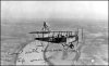
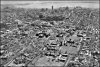
How was this photo taken? There were no drones in 1935.
They had airplanes then, and aerial photography was a big business then too.
Also, manned hot air balloons have exited since 1783 and the first aerial photography occured in the mid 19th century from those.
Lemme help you out.
In middle of the 1935 photo, that's Queen's Park. The wide oval road hasn't really been built yet. Obivous landmark of alignment.
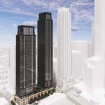
The tallest building in the background in 1935 is the Commerce Court North building is still standing
currently pictured in Street View and overhead
Google Earth view currently nearly hidden by taller towers now.
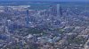
Here's a
Google Earth equivalent of the 1935 viewpoint.

Look at the middle of the photo.
Recognize that Queen's Park and some Queen's University buildings looks identical?
For the rear buildings, today, Trump Tower blocks its view, as it is nearly in front (albiet slightly to the left) between the Commerce Court and Queen's Park. The ScotiaBank building also partially bocks the view, as well. You can use those two modern buildings as the approximate location of the 1935 Commerce Court, when you line up your drone viewpoint.
Here's how I lined it all up:

So if you have a wide angle camera, try flying above
Varsity Centre (football field near Bloor). If you need to go further back for a narrower angle telescopic view instead, try flying above this
Huron School park which roughly lines up too.
Aim the camera pointing at various angles downwards (~20-25 degrees downwards from facing straight forward, and varying, just in case) with the Queen's Park roughly in the horizontal centerline of your camera field of view. Ideally, you want to match the camera angle of the center of the photograph. Also observe how the cluster of skyscrapers begin directly above the very right edge of the main Queen's Park building. That's approximately how will need to lline up your view. The depth of field might not be identical, but that's OK, you can fly really close to the original line-of-sight needed.
For altitude, you can kinda identify it this way: The tallest tower (Commerce Court North) points halfway into the water in the original photo. Given this tower is not visible, but the FCP tower (300 meter) is twice as tall as Commerce Court North (145 meter) -- you can use FCP (the big white tower) as the yardstick. But depending on the depth of field, this may not be ideal. You probably prefer to prioritize in making sure Queen's Park looks line up, rather than downtown looks lined up.
Done! Crop as needed, and then post the pic here.
OPTIONAL FOR MATH GEEKS: If you want to do a little trigonometry/Pythagorean's Theorem with a few landmarks, I bet you can determine the exact altitude of that 1935 aerial photo, to an accuracy of approximately 10 meters. Once you already figure out the depth of field of the photograph with some tricks, of course. I didn't look up the formulas necessary, I just eyeballed it with Google Earth, dragging things around until things lined up.
GOOGLE EARTH TIP: For other context views to do your best to line up a photo with Google Earth, you can use the CTRL+MouseDrag trick to change Google Earth angles in the browser, to do your best to line up. (Hold CTRL and left mouse button, while dragging mouse around in Google Earth). Zoom in/out as needed, until both the background and foreground looks right.
I'd just suggest flying it at a park that lines up (one of the two I suggested) and eyeballing.