I (shockingly) completely disagree about the A-Line being mixed with traffic is a good thing. Like, you're joking right?!
Again -- It's not my favourite scenario.
But it's far, far better than the 4-lane James St N scenario that required destroying far more what's already done on James St N.
Plus, it's the silver lining I also see. It keeps the door open to James St N pedestrianization in the future. (After enough TOD has happened, and traffic is divertable).
I spend a lot of time on James St N, and have frequently visited events at 294 James St N, to places like Mulberry's Cafe, my favourite poutine at Charred, to the various yummy places like Mesa, Saltlick, Knead, and I pick up some syrups/coffee equipment at Faema for home use, and I've strolled the whole length from St. Joes to Bayfront Park, and, yes, I've done it on SoBi too.
The above is why I am glad the 4-lane James scenario wasn't chosen, which would decimate and destroy the street, cutting out all the bumpouts, removing the trees, public art, etc. They may still have to do some of that temporarily if there's sewer work (trees being the most contentious issue). But with the opportunity to do things like brick-accenting the ROW and other "enhanced" streetscaping, a 2-lane streetscape is better than a 4-lane streetscape for James.
There were many other preferred scenarios, but if the LRT had to go north of Wilson on James St N. But was actually one of the better outcomes for a "Must Stay On James St N" scenario.
The only kink in that plan are the practical realities of LRT construction. In KW, we're seeing the entire road right of way being dug up wherever the LRT is going. In Uptown Waterloo, for a single direction of side-running LRT, they've gone sidewalk-to-sidewalk, even taking out street trees on the opposite side of the road.. It will have to be an exceptional preservation effort to convince them to work around existing trees.
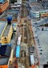
Uptown Waterloo. LRT will be on the left, roughly where the corduroy road is.
Now when you look at many other systems where preservation is important -- the installation of an LRT route in France for example -- a lot more care has been taken.
For example, the probably can rip up like that to Wilson, and north of GO station, but stage it carefully through James. That said, I'm not aware how terrible shape the under-infrastructure such as sewers are in James St N. Some interesting/factual/statistics would be very interesting reading. This will determine how much ripping up needs to be done, and whether the trees goes anyway.
Even if this happens and James gets temporarily destroyed, the 2-lane scenario means James comes back looking much better.
My opinion only -- not shared by the whole LRT advocacy team but we love discussing amongst ourselves of all the scenarios, keeping an open mind why one scenario may actually be better or worse than others, and what possible future outcomes can lead out of it.