News   Apr 23, 2024
 1.7K     5 
News   Apr 23, 2024
 545     0 
News   Apr 23, 2024
 1.3K     0 

Greater Toronto's Sprawl

Foreclosures will have a lot of growth, but it's actually part of real estate invest. The area around the GO stations and rail lines is more industrial than points further east, but that is probably a good thing to keep as is. I would guess there is little momentum for redevelopment of the low density sprawl to increase the population, but this city may have a hard time paying for the road and utility works
 
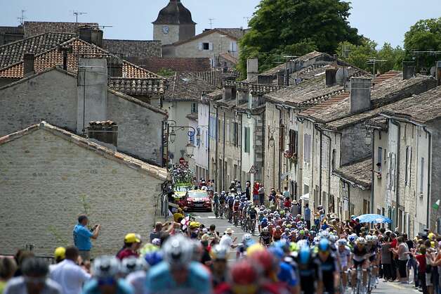
While watching the Tour de France in France, and later, the road bike races of the Olympics in England, I've noticed that the riders were riding through the narrow streets of villages and towns. They were generally riding through unchanged single lane narrow streets, with very little widening to accommodate the automobile with additional lanes.

628x471.jpg


_41889156_tour1416.jpg


55c05_120716054834-tour-de-france-stage-15-2-horizontal-gallery.jpg


_44808314_peloton.jpg


tour-de-france-2011-041.jpg


Here in Canada (and the United States), those roads would be widened to three lanes in each direction (total 6 lanes plus turn lanes) and the old houses torn down, and zoning restrictions imposed to avoid mixing of stores, homes, and light industry. All because it is more "safer" and "efficient".

What remains here is boring "town" centres, that look the same as other boring "town" centres. Some localities try to keep the old centres, but instead of building them outward, the outskirts look like any other subdivisions.
 
Last edited:
... Are you serious? Which historic village street here was widened to 6+ lanes, and historic buildings torn down, and mixed uses prohibited? Mississauga is like poster boy of sprawl, but even Queen St in Streetsville is still 3 lanes wide (one lane in each direction + parking). And yes, the historic buildings are still intact and mixed uses are still allowed, and many new mixed buildings have been built. You can go to City of Mississauga website and look at the zoning maps if you don't believe. Your depiction of Canadian cities is very strange and ridiculous.
 
... Are you serious? Which historic village street here was widened to 6+ lanes, and historic buildings torn down, and mixed uses prohibited? Mississauga is like poster boy of sprawl, but even Queen St in Streetsville is still 3 lanes wide (one lane in each direction + parking). And yes, the historic buildings are still intact and mixed uses are still allowed, and many new mixed buildings have been built. You can go to City of Mississauga website and look at the zoning maps if you don't believe. Your depiction of Canadian cities is very strange and ridiculous.

Dixie Road and Dundas Street East in Mississauga come to mind. Dundas Street & Dixie Road used to be four-lane roads by the 1950's, but it was widened to 7 lanes over the decades. Luckily for the cars by the 1950's, most buildings had front parking by then. In the 1950's, there was no Environment Assessments needed to make room for road expansion, they just took the space needed for a road right-of-way. I remember older buildings close to the road in that area, slowly being torn down for the right-of-way or to make space for front parking. Just look at the ages of the buildings at the Dixie & Dundas intersection, they're not old.

Luckily, Streetsville was still surrounded by farmland in the 1950's and 1960's. Road expansion was delayed. Now with Environment Assessment, Streetsville and other localities can delay and even stop them.
 
Dixie Road and Dundas Street East in Mississauga come to mind. Dundas Street & Dixie Road used to be four-lane roads by the 1950's, but it was widened to 7 lanes over the decades. Luckily for the cars by the 1950's, most buildings had front parking by then. In the 1950's, there was no Environment Assessments needed to make room for road expansion, they just took the space needed for a road right-of-way. I remember older buildings close to the road in that area, slowly being torn down for the right-of-way or to make space for front parking. Just look at the ages of the buildings at the Dixie & Dundas intersection, they're not old.

So there was a historic village at Dixie/Dundas that demolished in recent years due to road widening? What was the name of it? The old villages along Dundas I know of are Erindale (south of Erindale Park) and Cooksville (obv at Hurontario). Dundas Street still narrows to two lanes in each direction in both of these places.

If there was a village it probably wasn't anything on the scale of Erindale or Cooksville, let alone anything shown in those pictures of France you posted.

Luckily, Streetsville was still surrounded by farmland in the 1950's and 1960's. Road expansion was delayed. Now with Environment Assessment, Streetsville and other localities can delay and even stop them.

Why weren't Port Credit and Clarkson demolished then? Which roads were widened to six lanes in the 50s and 60s?
 
Last edited:
So there was a historic village at Dixie/Dundas that demolished in recent years due to road widening? What was the name of it? The old villages along Dundas I know of are Erindale (south of Erindale Park) and Cooksville (obv at Hurontario). Dundas Street still narrows to two lanes in each direction in both of these places.

If there was a village it probably wasn't anything on the scale of Erindale or Cooksville, let alone anything shown in those pictures of France you posted.


Why weren't Port Credit and Clarkson demolished then? Which roads were widened to six lanes in the 50s and 60s?

Dundas Street East (Mississauga) and Dixie Road were both widened to six+ lanes. The hamlet of Dixie is no more.

These hamlets and villages included Barberton, Britannia, Burnhamthorpe, Derry West, Elmbank, Frogmore, Hanlan, Harris’ Corners, Hawkins’ Corners, Lisgar, Lorne Park, Mount Charles, Palestine, Pucky Huddle, Sheridan and Summerville. Historically Churchville, Fraser’s Corners, Richview and Whaley’s Corners were part of Toronto Township

See this link.
 
So even before Mississauga existed (196:cool:, when the population was what would become Mississauga was still less than 200,000, maybe even when the QEW was still 4 lanes (pre-1960), both Dundas and Dixie Street were already widened to 7 lanes? Wow.
 
Yeah, most of the lost villages in Toronto were minor settlements. Dixie was a tiny settlement surrounded by a church (which still stands). Even by the 1870s some of these communities lost importance thanks to the railways, which concentrated settlement in larger villages and towns with railway access. Many older settlements faded away even before automobiles became common. Dixie would not have amounted to much by the time Dundas was widened to four lanes. Sprawl (not deliberate road construction) took care of perhaps the few houses left.

Meadowvale was remote enough and large enough (much larger than Dixie) that it remains intact, though increased heritage awareness by the time sprawl came around helped.

There's no conspiracy about it.
 
Dixie was actually located at Dundas and Cawthra, not Dundas and Dixie. That church is located at the NE corner and there's another old church, much larger, beside it too. So hamlet of Dixie is not really "no more". So I'm still wondering what village at Dundas and Dixie was destroyed when those roads were widened to 7 lanes in the 50s/60s.

You can still see some old houses along Eglinton which were incorporated into the strip malls, which never happened for Dundas. But actual villages getting demolished? Doesn't seem likely, except maybe in isolated cases. If you want examples of large scale demolition along old thoroughfares, you probably have to look to inner city Toronto and places like Regent Park.
 
... Are you serious? Which historic village street here was widened to 6+ lanes, and historic buildings torn down, and mixed uses prohibited? Mississauga is like poster boy of sprawl, but even Queen St in Streetsville is still 3 lanes wide (one lane in each direction + parking). And yes, the historic buildings are still intact and mixed uses are still allowed, and many new mixed buildings have been built. You can go to City of Mississauga website and look at the zoning maps if you don't believe. Your depiction of Canadian cities is very strange and ridiculous.

There may be some exaggeration to make the point but I'd have to agree completely with the observation 'W. K. Lis' is making here.
 
Click on this map for a larger map from http://www.ontarioroadmaps.ca/ for a map from 1960.


This map from 1950:
Niagara2.jpg


You can see the little villages that would have either adsorbed or disappeared. Some names are used for the new towns (IE. Pickering, Milton) or completely disappeared (IE. Lansing, Derry West)

In Europe, they would still exist. In Ontario, they are moved aside for road expansion.
 
Last edited:
So there was a historic village at Dixie/Dundas that demolished in recent years due to road widening? What was the name of it? The old villages along Dundas I know of are Erindale (south of Erindale Park) and Cooksville (obv at Hurontario). Dundas Street still narrows to two lanes in each direction in both of these places.

If there was a village it probably wasn't anything on the scale of Erindale or Cooksville, let alone anything shown in those pictures of France you posted.


Why weren't Port Credit and Clarkson demolished then? Which roads were widened to six lanes in the 50s and 60s?

You have a problem. There is a difference in development here and in Europe. My son had a friend who came here for 2 years while his father got transferred here for a job. When they left the mother said they want to live in the city (Bacalonia) which means she said they need to live in an apartment. Unlike the North America notion that to live in the city you can only reasonably do it as a family if it is a house. I asked her do they not have tall apartments there and she said people do not want them. There are some 12 storey located further out.

Look at Yorkvillle which use to have all those Victorian houses converted to shops and then torned down for a boutique hotel. Plus there is a condo there now and a garden centre, Where is the character of why people went to Yorkville? Its no longer there. Those condos are sold based on the character of the street but people don't realize once the condos are built they are the reason why the character changes. Same thing will happen to King St and restaurant row. The same thing with St Clair and the list goes on. I could understand building condos 6 storey high and then ground level store fronts with retail/business etc, But usually ground level = grand lobbies
 
Last edited:
This map from 1950:
You can see the little villages that would have either adsorbed or disappeared. Some names are used for the new towns (IE. Pickering, Milton) or completely disappeared (IE. Lansing, Derry West)

In Europe, they would still exist. In Ontario, they are moved aside for road expansion.

W.K. Lis, Derry West was a few houses and a gas station in the 1950s. Lansing was absorbed into what is now North York Centre. Most of those villages amounted to almost nothing, not like the hundreds' years old European villages you're think of.

As for many of the sames dots on that map- Nelles' Corners, South Cayuga, Renton, Fisherville, etc, places untouched by road expansion or sprawl, and you'll see that there's also amost nothing there. A few houses, maybe a church or solitary general store or gas station.

I do not mourn the disappearance of places like Clairville, Graham, Derry West, Dixie, Emery, etc, because they were too small and unimportant. What buildings were left were absorbed or replaced as is to some extent natural anyway. The odd exception of surviving landmarks, such as the Britannia school and the church, are interesting curiosities. Britannia wasn't much either, but the church and school lasted long enough to be saved.
 
As for many of the sames dots on that map- Nelles' Corners, South Cayuga, Renton, Fisherville, etc, places untouched by road expansion or sprawl, and you'll see that there's also amost nothing there. A few houses, maybe a church or solitary general store or gas station.
How many times have we driven down a rural road and be presented with a sign to warn us that we are entering the community of "XXX" and observe that there is nothing there today. The road is the same width it was when originally surveyed in the early 1800's but the communities have disappeared for reasons other than those promoted by W.K. Lis and other trolley fans or sprawl haters to further their positions.
 
Last edited:
How many times have we driven down a rural road and be presented with a sign to warn us that we are entering the community of "XXX" and observe that there is nothing there today. The road is the same width it was when originally surveyed in the early 1800's but the communities have disappeared for reasons other than those promoted by W.K. Lis and other trolley fans or sprawl haters to further their positions.

I think it is because the home owners are prevented from adding additions to their existing homes, or instead of rebuilding a new house on the old footprint, they are forced to build further away from the roadway. The road's right-of-way is slowly being expropriated to allow for a wider roadway at some future date. It doesn't happen in 10 years, but maybe in next century, which the powers-that-be want to allow for.

s0071_it10528.jpg

s0071_it10529.jpg
 

Back
Top