News   Apr 25, 2024
 113     0 
News   Apr 25, 2024
 314     0 
News   Apr 25, 2024
 507     0 

Ellesmere Road, 1952-2009

Lone Primate

Active Member
Member Bio
Joined
Aug 16, 2007
Messages
987
Reaction score
145
Location
Don Mills Willowdale Park Forest something I dunno
3498279351_2a4f28a01d_o.jpg


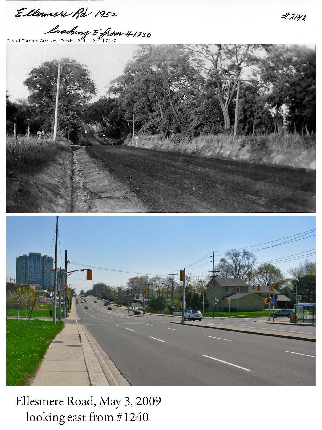
I was honestly slack-jawed when I saw the upper photo on the Toronto Public Library's website. If you're not familiar with Toronto, you probably won't think much of it... just a photo of a rural scene that's now urban Scarberia. But the thing is, Ellesemere Road is relatively mid-section in Toronto, and the view you see up top is the sort of thing I would have expected to see of the area from the 1920s or 1930s, not in the post-WWII boom.Not the way I imagined this part of town in the days of Leave It to Beaver.

The lower view is one I took this morning, from the same location, give or take a few yards. What was a farm fifty-some years ago is office space today, just off-screen to the left. Frankly, I'm not sure which view I prefer. They both have something to recommend them.
 
Now that really puts it into perspective. I'm accustomed to thinking of Metro as having been urbanized effectively forever. Being confronted with the evidence what used to be of the place before the developers had their way with it only makes me gnash my teeth a bit more.

Interesting choice of thread title, as well - before it loaded I had to wonder if they'd bulldozed or renamed the thing.
 
Consider, too, that the "tipping point" away from the old scene must have been within 5-10 years, in the aftermath of the completion of the 401 in Scarborough--and perhaps, development was *already* lapping this north on or t/w Ellesmere within a mile or so west of here (Ellesmere Statton PS, et al)
 
Growing up in an inner 905 suburb (Brampton), I can attest to how quickly things change - particuarly 2nd Line WHS - once a road passing through Meadowvale Village through on a treated loose-surface road (paved, but rough), now completely by-passed with Mavis Road and now 4 lanes, with plans to make it 6 lanes.

I believe it. I bet, like Adma, that this scene quickly changed after 1952. Certainly, by 1960, it was being developed. After all, Metro was two years from forming - Metro's regionalized infrastructure facilitated quicker sprawl, much like the Regional Municipalities did 15-20 years later.
 
It certainly has changed much, but I'd like to see more change. Expand Scarborough Centre west past Brimley, replace the industrial buildings on the north side (left side of the photo) of Ellesmere with high-rises, and it would truly be a remarkable transformation.

Interesting to note that country roads like in the first photo still exist in Scarborough, in Rouge Park in the northeast corner of the city.
 
I'm not that old but I remember when a lot of what was north of Finch or Steeles in central Scarborough looked much like that. Warden Avenue north of Steeles was a dirt road and looked almost exactly like the 1952 Ellesmere Rd. photo until the early 80's.
 
I honestly don't see what the fuss is all about...you could throw a dart at a map of Toronto and choose a site that was a farm or country road a few decades ago and is suburbia today. I'm reminded of that famous-ish photo of Bathurst & Steeles showing apartment towers marching up to the extreme suburban fringe, combining both farms and suburbia in one shot. If memory serves me correctly, that neighbourhood along Ellesmere was developed in the 50s, but the Scarborough Town Centre in the background was an empty green field until about 1972. Of course, I literally walked through a farm to get to high school and sat in classes overlooking a corn field...all this within walking distance of decades-old cookie cutter suburban developments and, unique to Toronto, suburban bus routes running at unheard of frequencies through such farm-laden suburbia. Steeles is still missing a curb in places!
 
Seven year ago, I used to work with a woman who told me that when she moved to North York, as a child in 1968, Steeles Avenue was still a dirt road. That was hard for me to imagine, but things I've learned since then have surprised me... like that Steeles wasn't even complete across the Humber till 1983, and now I'm reading that Warden was a dirt road north of Steeles at the same time. I live in North York and work in Markham so it's hard to imagine Warden that way... let alone Steeles.

When I first saw the shot of Ellesmere, I could barely believe the date. It just goes to show you how fast our city has ballooned in the past couple of generations. I mean, "Toronto", to me, in a practical sense, ends at about Major Mack these days (aside from the Yonge Street spine). To think of Ellesmere as countryside well after WWII is stunning.

For what it's worth, I was browsing through the aerial shots I've culled from the City Archives, and I happened to have s shot that included the area in the phote from about the same time. Oddly enough, there was already subdivision built south, west, and even NORTH of that spot. It was a pocket of rurality largely surrounded by burgeoning suburbia even at that point. Somehow, that makes the photo all that much more poignant to me...
 
Seven year ago, I used to work with a woman who told me that when she moved to North York, as a child in 1968, Steeles Avenue was still a dirt road. That was hard for me to imagine, but things I've learned since then have surprised me... like that Steeles wasn't even complete across the Humber till 1983, and now I'm reading that Warden was a dirt road north of Steeles at the same time. I live in North York and work in Markham so it's hard to imagine Warden that way... let alone Steeles.

When I first saw the shot of Ellesmere, I could barely believe the date. It just goes to show you how fast our city has ballooned in the past couple of generations. I mean, "Toronto", to me, in a practical sense, ends at about Major Mack these days (aside from the Yonge Street spine). To think of Ellesmere as countryside well after WWII is stunning.

I'm an east end refuge and I can confirm that until about the mid '70's (it was likely even later) Steels was indeed a dirt road from at least Warden Ave. all the way east to HWY 48 (aka Markham Road which was paved). My mom was a nervous wreck of a "city driver" back then (my family fled the city in 1977 to Keswick) and she would go to extreme lengths to drive where there was the least amount of traffic. My father's business was in Stouffville so when we'd drive up to see him on a Saturday morning my mom would take Warden up to Steeles, Steels along to the 10th line and then north from there to Main Street in Stouffville. Warden north of Finch was eventually paved (well before Bridlewood Mall was built), but it was dirt roads the rest of the way.

My father's parents had a substantial amount of property (their farm) that they purchased after they arrived from the Ukraine in the late 20's/early 30's - in the Lawrence and Birchmount area! As a kid I remember my dad used to point out where his family's farmland was and tell stories of what it was like when he was growing up in Scarborough in the '40's & '50's. It was all unpaved roads in that area but as the area began to get built up after WW2 it slowly began to change. As a kid, it was hard to imagine what it was like way back then, let alone today.

I hope this piece wasn't too boring!
 
I suppose re the un-pavedness of Steeles, Warden et al, I'm wondering whether the 70s was a turning point for *all* road paving, urban and rural. Once it was exceptional for anything outside of urbanity other than highways and maybe a few county roads to be paved; now, it's that which remains *un*paved that's exceptional, even going into the deepest rural parts of York Region...
 
Growing up in an inner 905 suburb (Brampton), I can attest to how quickly things change - particuarly 2nd Line WHS - once a road passing through Meadowvale Village through on a treated loose-surface road (paved, but rough), now completely by-passed with Mavis Road and now 4 lanes, with plans to make it 6 lanes.
Reminds me of when I moved to Brampton in 1988. Bovaird was a skinny two-laned and badly paved road that we occassionally took to visit family friends in Georgetown. Through Brampton the north side was farmer's fields while the south side was suburbia. East of McLaughlin it was all fields. By the time I left Brampton ten years later (1998), Bovaid had six lanes, was wider than the Gardiner Expressway, had turning lanes, bus bays and was completely developed on both sides from Airport Road, amost to Georgetown.
 
I am wondering if anyone has photos of the Warden-Ellesmere intersection under construction around 1966-1968.This is the dual CPR overpass bridges that corrected a terrible traffic problem when trains came to cross the intersection.This must have been voted the worst intersection in Metro Toronto before the new bridges for traffic congestion.I have 2 photos of the intersection before the bridges were built.Both photos are from the Scarborough Archives.In the first photo,I have marked which road is which because looking at the photo without the identification of each, is confusing seeing it for the first time.The actual track crossing is shared by both roads.
I'm sure the Toronto archives have all the photos,contractors etc,but I couldn't find where to start looking for the right section.
The new dual bridge overpass dated on the N/E wall is 1968.
Old_Warden_Ellesmere_Photo.jpg
warden_ellesmere_crossing.jpg
 

Attachments

  • Old_Warden_Ellesmere_Photo.jpg
    Old_Warden_Ellesmere_Photo.jpg
    42.7 KB · Views: 4,370
  • warden_ellesmere_crossing.jpg
    warden_ellesmere_crossing.jpg
    55.1 KB · Views: 2,022

Back
Top