News   Apr 24, 2024
 950     1 
News   Apr 24, 2024
 1.4K     1 
News   Apr 24, 2024
 620     0 

Downtown, Midtown and Uptown

The university district is so wrong as UofT is only west of Bay St.

It doesn't have to be a square, but what's the east and west boundaries of your so called midtown and uptown?

Just to give some "hang out" space, at least north towards Bloor. As for the eastern/west boundaries for midtown and uptown, I noted that it's Spadina-ish westwards (and this is the case for downtown as well) and Bayview for midtown/uptown. Further east, you get into the funkier/fun neighbourhoods (or places my parents think are "too far" from "what's happening" (they're in their 60s)).
 
We could define it this way:

Uptown: North of Eglinton to just north of Lawrence (yeah, I know, not a big area) if we are using the old City of Toronto as a border - North of Lawrence is where Toronto ends and North York begins.

Midtown: Just south of Eglinton (where Minto Midtown is) to just North of Bloor

University District: South of Bloor to just south of College

Downtown: Just south of College to Front

Harbourfront: Anything below

The east-west borders: A little further west than Spadina, but the eastern border depends on the part of the city. For example, the University District's eastern border would only go as far east as a bit past Yonge, while the midtown-uptown borders stretch out to a bit past Bayview).

It doesn't have to be a rectangle or square.

Thoughts?

Pretty much agree with this. Would also add Southcore: area bounded by Lower Simcoe and Bay St (maybe Yonge when 1-7 Yonge pops up?) Bremner to north of QQ.
 
Ryerson says hello, and maybe the 'University District' can run to Dundas on the east? Then OCADU says, yeah, Dundas feels about right on the west side, too...

Ryerson is between Dundas and Gerrard, doesn't fit your from Bloor to just south fo College description.
 
I may be in a minority, but I kind of like keeping the midtown as around Yonge and Bloor (including Queen's Park and U of T). Most of the hotels in the area still say they're "midtown" and it's pretty far from King and Queen to be thought of as one area. Amalgamation doesn't change that; North York doesn't become the new "uptown" and Yonge and Eg the new "midtown."

But if we're constituting what includes the downtown area we'd include both downtown and midtown, just as one sensibly include downtown and midtown for Manhattan and the Loop and Near North Side for Chicago.
 
I'd say pre-amalgamation Bloor would be mid-town, with Spadina and Jarvis going to the water. However as son as we included North York, East York Scarborough and Etobicoke... Yorkville, The Annex, CabbageTown, etc became a part of downtown.... so I would say (unofficially) the boundaries would be St Claire, Bathurst and the Don Valley are the boundaries for post-amalgamation Toronto. The CBD is simply another community within downtown.
 
Wasn't this area always know as Uptown? Why do we need a midtown? Seems a little too NYC to me.
 
If we're talking about north to south, Downtown is Queens Quay to Bloor and Midtown is upwards to Yonge/Eglinton.
 
The second post of that thread covers it:

Midtown is Yonge and Eg

Uptown - Yonge and Bloor

soooooooo..no concensus.

Yonge-Bloor was up from pre-amalgamation downtown Toronto, hence Uptown.

Yonge-Eglinton is in the middle of post-amalgamation Toronto, hence Midtown.

Names stick around long after they are relevant. Cabbagetown --> Irish settlers grew cabbage in their front yards. Forest Hill --> There was a forest at the top of Spadina. Today there are neither cabbages growing in Cabbagetown nor is there a forest in Forest Hill. Yonge-Bloor became a relevant focal point of mid-century Toronto when it was Toronto's uptown, while you could argue Yonge-Eglinton has became a more relevant focal point of Toronto post-amalgamation where it is Toronto's midtown. If that makes sense.

The fact these names are not externally consistent with each other in the Toronto context is perhaps besides the point.
 
What area would you designate downtown, and is the CBD seperate from downtown or part of it?

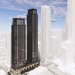
This graphic represents what is generally considered to be downtown (not sure if it's official or not). The boundaries are Bathurst in the West, the rail corridor at Dupont, Rosedale Valley Road, and the Don River in the East. Google Maps has the northern boundary at Bloor, however in recent years a lot of development has inched north of Bloor, especially around Yorkville and Davenport Road.

16469180730_4a0792e93c_z.jpg
 
Last edited:
Downtown - South of Bloor
Midtown - Bloor to Eglinton (inclusive)
Uptown - North of Eglinton

Anything West of Bathurst and East of Parliament is out of scope. That's it, you're welcome.
 
Ah, no. East of Parliament is still downtown to the Don River/DVP as far as anyone who lives here is concerned. Unlike some developers who want to market this area as the Lower East Side, we are actually called Downtown East, and you can clearly see that in the above map boundaries by the City that we are indeed located downtown and NOT out of scope by any stretch of the imagination. Our view of the core is far better here than from way up at Bloor St.
 

Back
Top