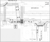
During rush hour (i.e. peak time) there were 4 lanes of traffic. One used exclusively by motorists and one shared with cyclists. Now there are 4 lanes of traffic...one for motorists and one for cyclists. The key analysis is rush hour...not offpeak.
So they are impacting traffic flows when it mattered. We only have a limited amount of road allowance space in the city. The study the city is doing is to make sure that it is used the most efficient. If I look at Harbord to Dupont how do I maximize the amount of usage (whether it is transit, cycle, walk or cars)?
At the inception the cycle groups said don't use one month nor one day as they expected an increase in usage over time. That's what the report will include...the usage on all streets for a long period of time.
But if the cycle lanes are only used by fair weather bikers what does that mean? They will drive or use transit in crappy weather. So then we don't have an efficient use of space on roads...or we have to double up on the cost by having 2 modes ready for these fair weather cyclists.
And this is what the study for. Hard numbers including trending over time to see how to maximize the use of public assets.
Dedicating the valuable road space you mentioned to single occupant automobiles is absolutely the
least efficient usage. And, if these numbers hold, we're talking about cyclists representing nearly 40% of total users.
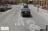
And to the rush hour point, this stretch of Bloor was
full of illegally parked cars every rush hour before the pilot; it's not as if this was a beautiful, unencumbered four lanes of vehicular travel. What's more, if we were having a proper discussion about how to reduce vehicular travel time across this stretch, we'd be looking at both left and right turn restrictions - those have
way more impact on vehicular travel times than bike lanes do. And that's also to say nothing of the fact that adding bike lanes has, in many places, sped up vehicular traffic - that's unsurprising, given that cyclists are fully within their right to take the entire lane.
What's troubling, though of course predictable given our current crop of councillors, is that cyclist safety isn't a metric that's being considered among the "hard data." It's simply beyond refutation to suggest that well designed, protected bike lanes dramatically increase safety for cyclists. And there's a huge problem in Toronto with regard to cyclist safety, which can be expected only to worsen given that cycling continues to increase in popularity, the population of downtown continues to grow, and cycle infrastructure in the city continues to exist in its sorry state.
Quite simply, what's a life, or a life changed worth? And how do you balance that against some of the other data we'll see come out of the pilot? Council is set to completely ignore that question, and that's horrific. Though not safety-related, we saw a similar dynamic of poorly weighted priorities play itself out with the Gardiner East decision, where the option pursued - which was hundreds of millions of dollars more expensive than the next alternative - was done so because it saved a
few thousand people a
few minutes off of their daily commutes.