News   Apr 25, 2024
 341     0 
News   Apr 25, 2024
 1K     4 
News   Apr 25, 2024
 1K     0 

Scarborough Waterfront Project (?, ?, TRCA)

Bluffs erosion concerns compel conservation authority to buy Scarborough house

3hSCEN_Conservation_Yard06132_Content.jpg


The Toronto and Region Conservation Authority has agreed to pay $1.4 million for a house on Midland Avenue overlooking the Scarborough Bluffs, and to let the owner stay on, paying market rent, for up to five years.

Shoreline protection works below the bluffs stopped rapid erosion which may have threatened many homes above, but a section of works below 1 Midland Ave. and three Fishleigh Drive homes was never completed.

A TRCA report in June said this was done deliberately, “as a result of objections from the public regarding the loss of a significant feature along the Scarborough Bluffs known as ‘the needles,’” below 1 Midland Ave.

Though it was then believed 1 Midland “would eventually require acquisition without shoreline protection in place.” the TRCA left the homes unprotected, buying the house at 85 Fishleigh Dr. and demolishing it in 1993.

After some “unexpected, progressive erosion,” however, a 2012 consultant’s review found the homes at 81 and 83 Fishleigh Dr. “would be at risk over the long-term” if the works were not extended under those properties.

The authority’s plans now call for extending works below the two Fishleigh houses in 2015 and adding a buttress on the slope.

Its report adds the former 85 Fishleigh Dr. property and the City of Toronto-owned road allowance at the foot of Midland “have the potential to be a good local park with views of the Lake Ontario.”


---

I don't know if this means they'd extend the service road / hiking trail at the shore line all the way to Bluffer's Park. If they did do that, it'd be a nice use of the park space, since there's an entrance to there at Glen Everest Road, just east of Rosetta McClain Gardens, and just west of Fishleigh.

128907.jpg


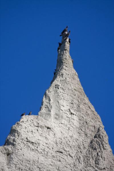
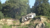
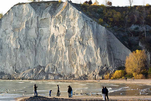
I believe below is the area in question to be fixed, from this thread.

1110195885_7da0461fe1_b.jpg


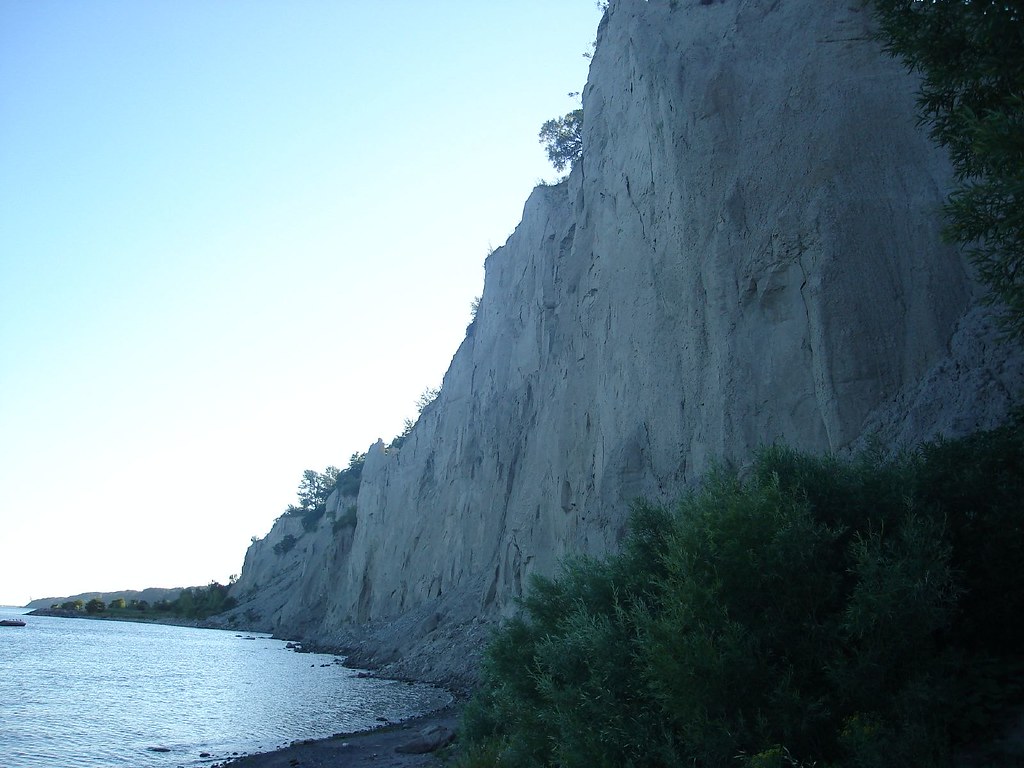
These would be shots from Bluffer's Park.

6a015390765c7e970b01a73dba9940970d-800wi


Currently there are stone breakwater barriers up until close to 81 Fishleigh but then it just stops there. If they extended it, it could go to a secondary (non-swimming) beach at Bluffer's Park, on the west side.

201266-bluffers-park.jpg


This would not affect the regular swimming beach at Bluffer's Park, since that is on the other side of the park area, east of the marina.
 
Last edited:
This document outlines the plan:

http://trca.on.ca/dotAsset/188533.pdf

The relevant pages are 152-155:

During the 1980’s there were numerous identified land slides, with a loss of tableland on the
properties located at Fishleigh Drive in proximity to the intersection of Midland Avenue and
Fishleigh Drive.

Shoreline stabilization measures were subsequently designed by Keith Phillpott Consulting
Limited on behalf of TRCA to address the erosion by eliminating wave action from Lake Ontario.
The objective of the design was to halt the erosion of the toe of the bluff, and allow the upper
slope to naturally recede to a stabile angle of repose. A review of the original project file
indicates that the shoreline stabilization works were terminated prior to completion of the
project at the easterly limits, below 81 Fishleigh Drive, as a result of objections from the public
regarding the loss of a significant feature along the Scarborough Bluffs known as the ‘needles’
below 1 Midland Avenue that would occur over time as the Bluffs flattened out and stabilized
with vegetation. It was believed that at the time there was sufficient shoreline protection works
in place to successfully protect the residences along Fishleigh Drive over the long-term, while 1
Midland Avenue would eventually require acquisition without shoreline protection in place.
Shortly after commencing construction of the shoreline stabilization works, TRCA purchased
the residential property at 85 Fishleigh Drive. The house was demolished shortly after in 1993.

As a result of unexpected, progressive erosion at 81-83 Fishleigh Drive despite the constructed
shoreline works, TRCA retained Terraprobe Limited in 2012 to review the existing site
conditions and update the Long Term Stable Slope Crest (LTSSC) position for these properties
and 1 Midland Avenue, to determine the maximum recession point of the Bluffs relative to the
existing dwellings and other essential structures. The results of the study confirmed that the
dwellings at 81 and 83 Fishleigh Drive would be at risk over the long-term if no additional
stabilization works were implemented at the site. The study also confirmed that as expected,
the dwelling at 1 Midland Avenue would also be at risk without any shoreline protection in
place.

The findings of the most recent geotechnical review of the LTSSC position, completed in 2012
by Terraprobe Inc. on behalf of TRCA, identified that the LTSSC is 21 metres from the existing
crest of slope, and would run through the house at #1 Midland Avenue. Further, the projection
of the LTSSC position is based on the assumption that the toe of the bluffs through this area is
static, and not subject to further erosion.

Currently this sector of the waterfront from the end of Fishleigh Drive to Brimley Road does not
feature shoreline protection, and is subject to erosion caused by ongoing wave action. The
preliminary proposed course of action is to slightly extend the shoreline protection below #81
and #83 Fishleigh Drive to install a buttress along a portion of the slope to provide long-term
protection for these homes, and to acquire the property at 1 Midland Avenue to leave the
remaining section of bluffs in the study area, previously referenced as “the needlesâ€, in a
natural state.


Fishleigh-Midland_zps88089f3b.jpg


---

So it looks like they would not extend the shoreline barrier all the way to Bluffer's Park.

Pro: Keeps the look of the Bluffs in this area unique.
Con: Walking path along the shore below Fishleigh will not reach Bluffer's Park.
 
There should be a continuous paved waterfront trail from the Beaches to Port Union. It would be a superb recreational amenity. Most local residents are probably older folks who live a suburban lifestyle driving to the park for a short walk once in a while, but people in general would benefit from an extended Martin-Goodman Trail in Scarborough for cycling, jogging and walking. There's probably a way to preserve the look of these bluffs while adding fill to extend the shoreline.
 
Last edited:
So it looks like they would not extend the shoreline barrier all the way to Bluffer's Park.

Pro: Keeps the look of the Bluffs in this area unique.
Con: Walking path along the shore below Fishleigh will not reach Bluffer's Park.

In a perfect world, they'd do a Humber style bridge from the s/w point of Bluffer's park and connect it to the proposed extension they're doing at the bottom of Midland.

Helps keep the waterfront trail at the waterfront, and preserves the needles, and protects the remaining houses as much as they can.

Costs big bucks though, so will not happen anytime soon.......
That would be awesome, but no, it ain't gonna happen in the next 50 years. :p

There should be a continuous paved waterfront trail from the Beaches to Port Union. It would be a superb recreational amenity. Most local residents are probably older folks who live a suburban lifestyle driving to the park for a short walk once in a while, but people in general would benefit from an extended Martin-Goodman Trail in Scarborough for cycling, jogging and walking. There's probably a way to preserve the look of these bluffs while adding fill to extend the shoreline.
There is a plan/hope to link everything up from Bluffer's Park going east, but much of the link up is on the top of the Bluffs, not at shore level. I believe it mostly won't be paved though either.

BTW, I live in the area and I would welcome a paved trail, but it seems most of my neighbours don't like the idea of a paved trail.

http://www.insidetoronto.com/news-s...roject-would-create-continuous-set-of-trails/

Scarborough Waterfront Project would create continuous set of trails
Plan would see trails linked from Bluffers Park to Pickering

Planning for a park that will cover the entire waterfront of Eastern Scarborough began with an announcement last week by the Toronto and Region Conservation Authority.

The TRCA is preparing an environmental study to create a “destination park featuring a system of linked scenic landscapes both along the top of the bluffs and at the water’s edge,†from Bluffers Park to East Point Park.

Meant to extend a waterfront park already completed further to the east in Port Union, the larger stretch along Lake Ontario will give strollers and cyclists “safe public access to and along the waterfront while respecting the natural and scientific importance of the Scarborough Bluffs.â€

Called the Scarborough Waterfront Project, it would effectively create a continuous set of trails, beaches and wetland areas from Bluffers to Pickering, and could cost $70 million.

“It could take 14 to 15 years to do all this work,†Connie Pinto, TRCA manager for special waterfront projects, said in an interview. “We want to hear from a lot of people and get their ideas.â€

The first step will be submitting terms of reference for the project’s environmental assessment to Ontario’s environment ministry.

Little known outside Scarborough, shoreline works along most of the future park’s length are already in place, and have continued to attract people even during their construction.

But the cobble beaches and road below the bluffs, which began with the sections below Sylvan Park and Sylvan Avenue east of the Bellamy Ravine, were meant to control erosion, not create a park.

Though many residents choose to walk or cycle the shoreline works between East Point and Bluffers today, “they aren’t up to park standard,†and some sections aren’t there at all, Pinto said.

The park requires a more complex study, with at least a year to weigh the options for access from top to bottom of the bluffs, recreational access to the water, trails, amenities, and places for people to congregate and rest.

Last September, Toronto council agreed to use water rates to pay for the study, which Pinto said may be launched at the start of 2015, and cost $3 million over two years.

The authority will soon advertise the first public information meeting, which will be in September, for the terms of reference.

Pinto said the study will give people a better understanding of sand from bluffs and where it goes. Sections of bluffs protected by the shoreworks are still exposed and continue to fall in “slippages,†she said, while water has pooled behind them and created shore habitat.

The constructed cobble beaches and breakwater groynes in Port Union and elsewhere along the Scarborough shore have already provided much-needed shelter for fish, Pinto added.

Residents seeking more on the waterfront project can visit trca.on.ca/swp for updates and news on public information sessions.

- Mike Adler
 
I hope there would be enough room to make a really wide trail since it will probably be very popular, if the Martin Goodman trail is any indication.
 
There's something askew when the government is somehow made responsible to pay $1.2 million for a private property that will one day fall into the drink without expensive public efforts to protect the cliffs from below, but the neighbours still feel entitled to protest any improvements that might attract people from away to enjoy the recreational opportunities. My Streetview isn't working well right now, so I can't check if my memory is correct, but is this the spot where one or two large residences have been built at the turn within the last two or three years, I'd think it would be iimmediately north of the 1 Midland property?

The character of the Bluffs do seem to change once they're not being beat by waves and vegetation begins growing up their sides. It would be a bit of a shame to lose that one stark face that overlooks the park. On the otherhand, it would be great to have a continuous path.
 
There's something askew when the government is somehow made responsible to pay $1.2 million for a private property that will one day fall into the drink without expensive public efforts to protect the cliffs from below, but the neighbours still feel entitled to protest any improvements that might attract people from away to enjoy the recreational opportunities. My Streetview isn't working well right now, so I can't check if my memory is correct, but is this the spot where one or two large residences have been built at the turn within the last two or three years, I'd think it would be iimmediately north of the 1 Midland property?
You must be thinking of a different location. There have been large residences built in a last 5 years on Fishleigh, but those properties were already in the zone that had the shoreline protection done previously. AFAIK, the couple of houses immediately north of 1 Midland haven't changed in decades.

Also, they knew this was going to happen but chose not to protect it (or protect the east end of Fishleigh with those two Fishleigh houses) anyway, to keep the aesthetics.

But yeah, I wish people would appreciate the $1.4 (not 1.2) million spent more, and would be more open to a paved trail. Mind you, I don't think there is a budget for paving at the moment anyway. I wonder what it would have cost to buy the house back when the rest of the shoreline protection was being done though. Or what it would have cost to finish the shoreline protection so they wouldn't have needed to buy the house.
 
Last edited:
It's not the $1.4 million* that the neighbours should be grateful for. It's the multiple millions spent trucking rocks down below to protect their own properties and the properties of their neighbours. The least return that taxpayers from elsewhere should expect is that some of the natural treasures of the area become more accessible.

*Difficult to understand how a property that's falling away is worth that much money.

Maybe the properties I was thinking of are around another bend at the top of the Bluffs. Thinking now that maybe it was just west of the park where the Scarborough Arts Council building is.
 
Last edited:
Scarborough Waterfront Project is Launched

In July 2014, Toronto and Region Conservation Authority (TRCA) initiated a study under the Environmental Assessment Act to create a new waterfront park along the Lake Ontario shoreline from Bluffer's Park to East Point Park. The purpose of the project is to create a destination park featuring a system of linked scenic landscapes both along the top of the bluffs and at the water's edge integrating shoreline regeneration, public access and safety, and natural heritage.

You are invited to attend the first Public Information Centre for the Terms of Reference:

PUBLIC INFORMATION CENTRE #1 – Scarborough Waterfront Project Terms of Reference Wednesday, September 10, 2014 at 7 pm
Scarborough Village Recreation Centre, 3600 Kingston Rd.

Open House – 7:00 p.m.
Presentation – 7:30 p.m.
Question & Answer Period / Feedback – 8 p.m.

The purpose of this first public information centre is to introduce the project and the planning process. Please RSVP via Eventbrite at https://scarboroughwaterfrontproject.eventbrite.ca You may also visit the website at http://trca.on.ca/swp to subscribe to the e-newsletter to receive updates and information about the project.
 
It should be noted that the shoreline below those homes was supposed to have been protected, but the work was stopped below those homes because it was felt it would wreck a natural feature, called the needles.

scarborough-bluffs09.jpg


However, they are now largely lost anyway, with the continued erosion.

Continuation of the erosion protection below those homes was approved last year. In fact, signs have now gone up in the area (on Fishleigh at Midland) indicating the work will start soon.

The issue is outlined on pages 176-178 of this PDF:

http://www.trca.on.ca/dotAsset/208219.pdf

In 1980 Geocon Inc. carried out an extensive erosion control study of the Scarborough Bluffs as
a whole. This study identified Fishleigh Drive as one of the sectors along the Scarborough
Bluffs in need of erosion control. In response to this, TRCA (MTRCA at the time) retained Keith
Philpott Consulting in 1987 to provide design options for remedial shoreline protection works.
In 1988, Terraprobe Limited was retained to conduct subsurface investigations and establish
the long term stable slope crest (LTSSC). Later that year, based on recommendations and
analysis from Keith Philpott Consulting and Terraprobe Inc., TRCA produced an Environmental
Study Report (ESR) under the Class Environmental Assessment (EA) for Water Management
Structures (now Remedial Flood and Erosion Control Projects). This report, entitled Fishleigh
Drive Erosion Control Project, recommended offshore fill and an armourstone revetment
approximately 560 metres (m) long below Nos. 33 – 85 Fishleigh Drive and 1 Midland Avenue,
to eliminate toe erosion and encourage self-stabilization of the bluffs. The Class EA was
approved and construction began in 1988.

In 1994, TRCA suspended construction to reassess the potential impacts of the project on an
important portion of the Bluffs known as the “Needles”. W. F. Baird & Associates was hired to
provide options for a termination point of the armourstone revetment structure. They provided
six options and evaluated the feasibility of each at providing adequate erosion protection while
preserving the Needles feature. A committee was established consisting of representatives
from Metropolitan Toronto, City of Scarborough, Waterfront Regeneration Trust, local politicians
and affected homeowners. Collectively, it was decided to terminate the revetment below 83
Fishleigh Drive (150 metres short of the 1988 approved length). The motion was carried under
the stipulation that “authority staff investigate further options to ensure the long term safety and
protection of Nos. 1 and 5 Midland Avenue and Nos. 81 and 83 Fishleigh Drive” (Water and
Related Land Management Advisory Board, 1996).

Since the suspension of the shoreline works in 1994, progressive erosion has continued at 81
and 83 Fishleigh Drive and 1 Midland Avenue. In response TRCA has retained Terraprobe Inc.
to complete further slope stability reviews at the site, producing reports in 1993, 2002, 2003,
2005, 2006 and 2012. These reports, coupled with TRCA monitoring, document the continued
erosion in this area. In 2012, assuming no further toe erosion, it was predicted that the LTSSC
would pass through the house at 1 Midland Avenue, and approximately 1 m from the house at
83 Fishleigh Drive and within 6 m of the house at 81 Fishleigh Drive.

A cost benefit analysis focusing on the cost of property acquisition versus the cost of shoreline
protection, while considering the conservation of the "Needles" formation, was undertaken in
determining the preferred course of action. Acquisition of 81 and 83 Fishleigh Drive, including
associated expenses was estimate at $2,000,000. Furthermore the existence of infrastructure
located in the vicinity of the conjunction of Fishleigh Drive and Midland Avenue would be
subject to future decommission or relocation. Assuming the availability of clean rubble fill
materials, shoreline works below 81 and 83 Fishleigh Drive were estimated at $750,000.
Although the cost of purchasing 1 Midland Avenue was valued at $1,500,000, the negative
impacts of shoreline protection implementation to the “Needles” feature were deemed too
great.

Based on this cost benefit analysis, the preferred course of action was determined to be
acquisition and future demolition of 1 Midland Avenue, and the extension of shoreline
protection and implementation of a slope buttress below 81 and 83 Fishleigh Drive. In 2014, 1
Midland Avenue was acquired. The previous owner is currently renting at market value until no
later than 2019, at which point the at-risk home is scheduled to be demolished and the land
returned to greenspace.
 
Here's a house on the edge of the bluffs the City should have bought and taken care of a long time ago:

bluffs.png
 

Attachments

  • bluffs.png
    bluffs.png
    1.4 MB · Views: 2,161
That may be Billy Van's old cottage. Hilarious House of Frightenstein will remember him.

I would love to see a connecting boardwalk or bridge out over the water for biking or walking. They need to keep the Bluffs looking as natural as possible and also respect the wildlife. Coyotes, foxes, deer, squirrels, mink, raccoons, fish, turtles, frogs and tons of birds live there.
 

Back
Top