News   Apr 17, 2024
 1.3K     0 
News   Apr 17, 2024
 331     0 
News   Apr 17, 2024
 2K     1 

Transit Fantasy Maps

Really? 45 - 50%? Your numbers are outdated. According to Rogers most recent quarterly report, 70% of their Wireless subscribers were on smartphones. That leaves just 30% on feature-phones, mobile hotspots and other miscellaneous devices.
And what percentage don't have cell phones?

Or don't use data on cell phones. I know people with smartphones who only use phone and text.

I don't see any need for TTC to make app. That costs money. They've spent their money on making the data public. Anyone can make an app. I wouldn't be surprised if realtime transit data is part of Google Maps app at some point ...
 
And what percentage don't have cell phones?

Or don't use data on cell phones. I know people with smartphones who only use phone and text.

You really have to be kidding me. Every time I ride to TTC there are countless people using their smartphones and there are more every day. Even if only 33% of riders have smartphones with data, investing in a good mobile app would very likely be the single best and cheapest investment in customer service the TTC can make. I don't see how you can possibly deny this.

I don't see any need for TTC to make app. That costs money. They've spent their money on making the data public.

We're talking anywhere from a few hundred dollars to a few thousand dollars for this. Not hundreds of thousands or millions. It will hardly make a dent in the TTCs pocketbook and I'm almost certain that fares from the small amount of extra ridership this app will generate will more than make up for the tiny development cost.

Anyone can make an app. I wouldn't be surprised if realtime transit data is part of Google Maps app at some point ...

If I remember correctly the TTC's NextBus API only provides vehicle location and estimated arrival times for surface routes. It doesn't even have delay notifications. The TTC would be able to tap into a much more extensive data set. Just one of the things a TTC designed mobile app would be able to do is send push notifications to a device to alert customers the moment there is a delay along their route. No third party TTC app is capable of this.
 
You really have to be kidding me. Every time I ride to TTC there are countless people using their smartphones and there are more every day. Even if only 33% of riders have smartphones with data, investing in a good mobile app would very likely be the single best and cheapest investment in customer service the TTC can make. I don't see how you can possibly deny this.
Because the last thing we want is TTC to get into the app business. They are providing the data. There are hundreds of transit systems in North America providing similar data. The app will appear. And likely a better app than what the TTC would spend a lot of money on.

Look at all the trouble they went creating the on-line Trip Planner - http://www.ttc.ca/Trip_planner/index.jsp

It's not bad ... but does anyone use it? No. Because Google Maps released one at about the same time and does it better, using TTC's own data.

We're talking anywhere from a few hundred dollars to a few thousand dollars for this. Not hundreds of thousands or millions.
If you think app development costs so little, then you really have absolutely no idea how this stuff works. I'd think it would be 5-digits if they were to try and buy some off-the-shelf app and have it modified for their purposed. And easily 6 digits from scratch, probably more. Then there's maintenance ... forever. There are already very good 3rd party apps, and they will only get better.

If I remember correctly the TTC's NextBus API only provides vehicle location and estimated arrival times for surface routes. It doesn't even have delay notifications. The TTC would be able to tap into a much more extensive data set.
And yet some the existing private apps do already incorporate TTC delay notifications, they simply cross-reference the route your using with the service alert feed.

Just one of the things a TTC designed mobile app would be able to do is send push notifications to a device to alert customers the moment there is a delay along their route. No third party TTC app is capable of this.
Doesn't http://www.ttc.ca/Service_Advisories/My_ttc_e_services/index.jsp already do this?

I don't see why a 3rd party app can't integrate service alerts.
 
Because the last thing we want is TTC to get into the app business. They are providing the data. There are hundreds of transit systems in North America providing similar data. The app will appear. And likely a better app than what the TTC would spend a lot of money on.

Okay maybe you're right. But for that to happen the TTC will seriously have to upgrade their NextBus API. It's really lacking at the moment.

If you think app development costs so little, then you really have absolutely no idea how this stuff works. I'd think it would be 5-digits if they were to try and buy some off-the-shelf app and have it modified for their purposed. And easily 6 digits from scratch.

I don't know the details of the Commissions back end so I can't comment on an exact price. But this application would not be built from scratch. The TTC already has the NextBus system set up. I presume that the system would need a few upgrades. Unless you have any information to the contrary I'm going to bet that it would be less than $100,000 depending on how the TTC organizes their vehicle data. That is still likely much less than other TTC customer service programs that will have a much smaller impact.

And yet some the existing private apps do already incorporate TTC delay notifications.

Wasn't aware of this. The TTC applications I see on the Google Play Store and iTunes App Store only have vehicle location and estimated arrival information for surface routes.

Doesn't http://www.ttc.ca/Service_Advisories...ices/index.jsp already do this?

I don't see why a 3rd party app can't integrate service alerts.

The TTC would have to allow app devs to do that. Developers are at the mercy of the TTC. There is only so much they can do with vehicle position and arrival information. The TTC could do so much more including mobile fare payment via Passbook on iOS and NFC on Android and Blackberry.
 
Last edited:
Wasn't aware of this. The TTC applications I see on the Google Play Store and iTunes App Store only have vehicle location and estimated arrival information for surface routes.
Ah ... when I say app, I'm including websites (given I have a Blackberry, and there aren't any actual apps). http://whereismystreetcar.appspot.com/ shows service alerts, which it sucks in from @TTCnotices twitter feed - I'd think any site or app could do that.

Though actually I find TransSee - http://doconnor.homeip.net/TransSee/RouteList.php?a=ttc of more utility from the Blackberry (minus the service alerts).

The TTC would have to allow app devs to do that.
Why would TTC have to allow app devs to simply use a TTC twitter feed?
 
I'm not feeling these new maps. At a glance, they're hard to read and orient yourself as to where you are. Maybe people who use the TTC more would get it. But I'd expect to be able to orient myself based on the subway system, and the subways are pretty much invisible on these maps.

There's a key map in the bottom right corner showing the full subway and the relevant surface routes (example). I think it's pretty effective. Although I do agree that it might be nice to show more of the subway on the main map too.

Actually, I'm really impressed with these maps -- maybe not perfect, but hugely more useful than what's currently up. I love that the central part of the map shows all of the local streets and pinpoints the exact locations of all the nearby bus stops.
 
What the TTC really should do is make iOS/Android app. Almost everyone has a smartphone. It is the single best thing they can do improve customer service.

OC Transpo in Ottawa has an iOS app. Officially released by them too. Works quite well, and is quite accurate.
 
Last edited:
OC Transpo in Ottawa has an iOS app. Officially released by them too. Works quite well, and is quite accurate.
How much did it cost? Who is going to upgrade it when Apple upgrades their iOS? And what about Blackberry and Android?

Also, I didn't think OC Transpo's app had realtime bus information - just service announcements. And I also didn't think it could offer you routing suggesting from A to B. I thought it was more just a library of schedules and stops - and at best could tell you where the nearest routes and stops were.

Sure, an app like this might have some utility (it would be similar to GO's app). But it isn't all that one needs. It doesn't do the difficult stuff.
 
TTC should definitely have an app. It's a no-brainer. They need to adapt to the new realities of this century.
 
How much did it cost? Who is going to upgrade it when Apple upgrades their iOS? And what about Blackberry and Android?

Don't know. They did the update when iOS updated (it's also iPhone 5 compatible). They've been doing updates to it to improve the UI quite a bit. And don't know (don't use either of those).

Also, I didn't think OC Transpo's app had realtime bus information - just service announcements. And I also didn't think it could offer you routing suggesting from A to B. I thought it was more just a library of schedules and stops - and at best could tell you where the nearest routes and stops were.

Sure, an app like this might have some utility (it would be similar to GO's app). But it isn't all that one needs. It doesn't do the difficult stuff.

It does have real-time bus data. In fact, I'm looking at the info for the 118 right now. I have my stop selected as a favourite, and it has a vertical list of every stop on the route, with a little bus icon showing at which stop the bus is at. Right now the next bus is 7 stops and 3 minutes away from my stop.

They also do have a section for service announcements. They haven't added the trip planner yet, but there's a link to the OC Transpo mobile site, which I believe does do that (I know the full site does it).

Here's a few snapshots, showing the favourites page (with live updated info), and the route page (showing where the buses are relative to your stop):
IMG_1851.jpg
IMG_1852.jpg
 

Attachments

  • IMG_1851.jpg
    IMG_1851.jpg
    11 KB · Views: 491
  • IMG_1852.jpg
    IMG_1852.jpg
    9.6 KB · Views: 489
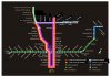
I was thinking about the Sheppard West subway and figured there must be a way of doing it to provide more benefit. I am sure I have seen parts of this before, but I will consolidate it into one plan. Essentially, the Sheppard subway would be interlined with the Spadina line at the (existing) Downsview station, alternating going north and south. Here is the resulting TTC map (excuse the poor graphics).

System Map (1).jpg


So we have 4 lines (actually 3, but I gave the short-turn one its own name) operating and the YUS and Spadina lines. At peak, the trains have the following frequencies:

- Yonge-University-Vaughan (yellow) = 4 minutes
- Yonge-University-Downsview (red) = 8 minutes
- Sheppard-University-Yonge (pink) = 8 minutes
- Sheppard-Vaughan (blue) = 8 minutes

Each train would be colour coded so that passenger know which direction there train would go (in addition to the sign on the front of the train) - even the short turn train has a colour coding so that passengers will not complain about being on a train the short-turns.

This means that:
- On Sheppard, trains are every 4 minutes going eastbound and then every 8 minutes going west then north and every 8 minutes going west then south - (i.e. a train every 4 minutes).
- On the Spadina Extension, 3 trains every 8 minutes (gaps of 2, 2, 4 minutes) go northbound, while trains go every 4 minutes south along the existing YUS and trains are every 8 minutes to go south then east.
- On the existing portion of the YUS, 3 trains are every 8 minutes go towards Downsview (2 of which continue to Vaughan) and 1 train every 8 minutes go towards Downsview then east. The frequency towards Finch is 2 minutes.

To accomplish this, there would be a Downsview Station on the Sheppard line. The Sheppard line would go under the Spadina line and then curve down to join the Spadina line north of Wilson (with the northbound to eastbound ramp going over the Spadina line) and also the Sheppard line would go north and join the Spadina line south of Sheppard West (the one with the GO hub) (with the westbound to northbound ramp going over the Spadina line and joining in from the north). (I do show the option of the tracks crossing here, but with farther thought, I think it is worth separating the tracks here). There would be one intersection where the westbound to southbound ramp crosses the southbound to eastbound ramp - this would be acceptable since the frequency on these ramps is 8 minutes for each movement.

Here it is graphically (again, not the greatest drawing skills)

Downsview (1).jpg


This interlining proposal differs from the Lower Bay Wye that was used decades ago since the frequency on all sides of the Wye are not the same. The Sheppard westbound to southbound train could arrive early to Downsview and have a planned wait to ensure that it joins the Spadina line southbound at the correct point in time - since it is maintaining the frequency southbound that is critical.

The curves to make up these ramps are about 350m radius, about the same (actually a bit more gradual) as the Spadina curve from Allen to Sheppard West. However, they are less critical since the train frequency on these ramps is not as critical and they could be taken at a slower speed - the only important thing is that the trains be on time to head southbound.

There would be next to no transfers between the two Downsview Stations (the Spadina one and the Sheppard one) due to the interlining - so they could be separted by some distance so that the new Downsview Station would not have to be built under the existing station - they would be close enough to share the bus terminal though. The station is shown at Faywood, although it may not be needed since the Downsvew Station would extend well East of Dufferin. There would be twin tunnels going under Spadina at Sheppard - which would add some complexities - but the remaining ramps would go above the existing Spadina line, plus all the construction would involve simple excavation and is to the west of Allen road (and south of Sheppard) with minimal to no disruption to traffic. Construction does get a bit close to the runway, which may be a problem.

The last thing is that all trains would consist of 8 cars, except for the Sheppard-Vaughan subway (blue) which would consist of 4 cars. For all stations at Bloor and north, the front of the trains would line up with the end of the platform and the last car, plus perhaps one door from the 7th car, would not line up with the platform and would not open. (When on the Sheppard line, the last 4 cars would not line up at the station and would not have doors open). For all stations south of Bloor, the back of the train would line up with the end of the platform and the first car, plus perhaps one door from the 2nd car, would not line up this the station and would not open. Some smart commuters would enter the 7th car north of Bloor and walk-through to the 8th car so they could disembark from the last car south of Bloor. These 8 car trains would have 30% more capacity than the current 6 car trains. (As stations get busier, the platforms on select high-volume stations could be increased so that the full 8 car train would fit - I am thinking Yonge-Bloor and Union where adding some extra platform length is easier than adding a whole new platform)
 

Attachments

  • System Map (1).jpg
    System Map (1).jpg
    44.6 KB · Views: 709
  • Downsview (1).jpg
    Downsview (1).jpg
    79 KB · Views: 597

Back
Top