News   Apr 19, 2024
 355     0 
News   Apr 18, 2024
 1K     1 
News   Apr 18, 2024
 9K     2 

The Weather

Official heat wave. Well, it was hot in Minneapolis, hot in Chicago, hotter still in Toronto. Guess I'll grit my teeth till it blows over. Wonder if elders die here in GTA like they do in Chicago in brutal heat.

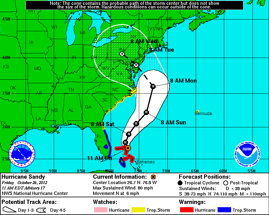
Saw something that suggested that the rampant flooding everywhere you look is related to melting ice caps and other climate change things. There's a hurricane forming in the mid-Atlantic instead of off West Africa which is where they traditionally start.
 
Heat wave is supposed to be over tomorrow; it's not the heat so much as the humidity. But they've promised a couple of beautiful summer days for the weekend, so fingers crossed!

Yes, people die or get serious heat stroke, unfortunately. That's why they declare heat alerts and open cooling centres in places like and community centres: http://www.toronto.ca/health/heatalerts/beatheat_ac_places.htm
 
What's with all these STUPID people leaving dogs in their cars during a heatwave let alone in the summer? I saw on the news tonight that they've had around 150 calls to rescue distressed dogs in cars over the past several days, I have to wonder how many died. Stupid, stupid people, they should be made to sit in a vehicle in similar conditions for just 15 minutes and see how they like it.
 
We really need rain. Three or four days of it. Very soon.
 
Saw something that suggested that the rampant flooding everywhere you look is related to melting ice caps and other climate change things. There's a hurricane forming in the mid-Atlantic instead of off West Africa which is where they traditionally start.

Unprecedented Greenland Ice Sheet Surface Melt

ScienceDaily (July 24, 2012) — For several days this month, Greenland's surface ice cover melted over a larger area than at any time in more than 30 years of satellite observations. Nearly the entire ice cover of Greenland, from its thin, low-lying coastal edges to its two-mile-thick center, experienced some degree of melting at its surface, according to measurements from three independent satellites analyzed by NASA and university scientists.

This extreme melt event coincided with an unusually strong ridge of warm air, or a heat dome, over Greenland. The ridge was one of a series that has dominated Greenland's weather since the end of May. "Each successive ridge has been stronger than the previous one," said Mote. This latest heat dome started to move over Greenland on July 8, and then parked itself over the ice sheet about three days later. By July 16, it had begun to dissipate.

Even the area around Summit Station in central Greenland, which at 2 miles above sea level is near the highest point of the ice sheet, showed signs of melting. Such pronounced melting at Summit and across the ice sheet has not occurred since 1889, according to ice cores analyzed by Kaitlin Keegan at Dartmouth College in Hanover, N.H.

120724131608-large.jpg


Extent of surface melt over Greenland’s ice sheet on July 8 (left) and July 12 (right). Measurements from three satellites showed that on July 8, about 40 percent of the ice sheet had undergone thawing at or near the surface. In just a few days, the melting had dramatically accelerated and an estimated 97 percent of the ice sheet surface had thawed by July 12. In the image, the areas classified as “probable melt” (light pink) correspond to those sites where at least one satellite detected surface melting. The areas classified as “melt” (dark pink) correspond to sites where two or three satellites detected surface melting. The satellites are measuring different physical properties at different scales and are passing over Greenland at different times. As a whole, they provide a picture of an extreme melt event about which scientists are very confident.
 
5 day rainfall totals... toronto in the 2-4 inch catergory.... I suspect we could end up more then that, some of the model runs were stalling the remnants over Toronto with a sub 960 pressure this morning :eek:

Sandy_rainfall.gif
 
5 day rainfall totals... toronto in the 2-4 inch catergory....
50 to 100 mm.

I suspect we could end up more then that, some of the model runs were stalling the remnants over Toronto with a sub 960 pressure this morning
That would be interesting ...

Though perhaps the whole storm could simply continue on it's current trajectory, fail to come inland, and just leave us with a few days of showers.
 
There are recycling bins EVERYWHERE! Why would they continue with garbage collection on Monday night when we knew this was coming?
 
Looks like the weatherman was finally right! The last few "snow storms" turned out to be nothing but a light dusting.
 
15-20cm used to be a regular event not even a decade ago when we still had real winters here, today it's "snowmageddon". People aren't used to driving in these conditions anymore and have lost their skills driving on slippery and snow covered roads. Everyone laughs about Lastman calling in the army, which was a bit dramatic but we did get around 70-80cm over 24 hours, then it was gone four days later after a warm system moved in.
 
15-20cm used to be a regular event not even a decade ago when we still had real winters here, today it's "snowmageddon". People aren't used to driving in these conditions anymore and have lost their skills driving on slippery and snow covered roads. Everyone laughs about Lastman calling in the army, which was a bit dramatic but we did get around 70-80cm over 24 hours, then it was gone four days later after a warm system moved in.

So true. I laugh at the drivers with these big SUV's spinning and swerving all over the place. i guess these dumb drivers think 4WD makes them impervious to snow and ice!
 

Back
Top