News   Apr 24, 2024
 93     0 
News   Apr 23, 2024
 1.9K     5 
News   Apr 23, 2024
 583     0 

Miscellany Toronto Photographs: Then and Now

Everyone: More interesting information and pics here at Miscellany Toronto! I will mention these new pics:
3/22 Lakeshore/Parklawn - about 1960. The taxi and Labatt's truck stand out among those vintage vehicles...I enjoy pics like this!
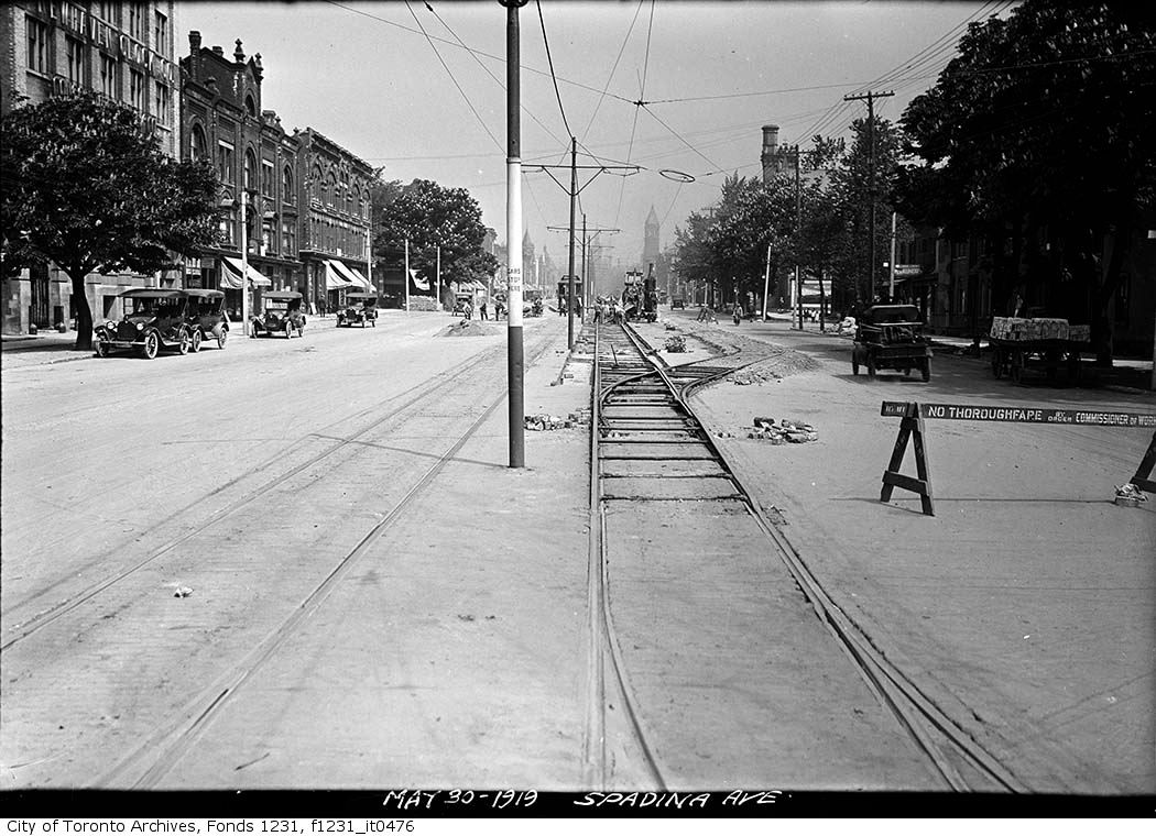
3/23 College/Bellevue 6/58 - GM vehicles noted like "55 Chevy(?) Nomad Bakery wagon and a Buick or Olds parked in front of that small truck...
3/24 International Harvester of Canada - an interesting art-decoish building 6/14/40 from the 30s...
-The Lux Theatre Burlesque is quite interesting - and the women from that day are quite attractive...
LI MIKE
 
Oh but it's very much alive, Mustapha...


VCR's killed the live strip business. The internet is now killing the VHS/DVD business.

I was curious enough to Google: "burlesque in Toronto". Seems there is quite the "scene" and a following. They just don't have dedicated street level venues for it nowadays.


March 25 addition.


Goldie sent me the 1912 Toronto archive picture below of Bathurst street going into and out of Nordheimer ravine. He suggested I check to see if the hill was still that steep nowadays. Always curious myself I decided to go have a look. Note the line of hydro poles. View is looking north.


March 20 2010. Nope. :) I remember now that I once innocently set out on an errand to fetch a "skyhook" from the construction superintendents office during a summer job in my youth...


The line of hydro poles still stand alongside the long vanished roadway.

 
[QUOTE
Goldie sent me the 1912 Toronto archive picture below of Bathurst street going into and out of Nordheimer ravine. He suggested I check to see if the hill was still that steep nowadays. Always curious myself I decided to go have a look. Note the line of hydro poles. View is looking north.


The line of hydro poles still stand alongside the long vanished roadway.

[/QUOTE]

Isn't it amazing what a little of exploration will discover? I'm pleased that you found the old, hidden hydro poles.
 
March 25 addition.


Goldie sent me the 1912 Toronto archive picture below of Bathurst street going into and out of Nordheimer ravine. He suggested I check to see if the hill was still that steep nowadays. Always curious myself I decided to go have a look. Note the line of hydro poles. View is looking north.


What a great picture! I've never seen this one before.

It's contemporary with this one, which looks like it would be looking south from the bridge:


Two old "Nows and Thens" from a history of the Township of York;


The "new" bridge (replaced, I believe in the 80's by the current one):

 
Last edited:
Goldie, I forgot to mention that those hydro poles are still in service/use.

thecharioteer, the latest bridge has a plaque at the SE corner that says "1983" and "2003".
 
More recently than 2003, they removed the shoulder lanes from both sides of the bridge.

Compare your 'now' pic with the birds-eye from just a couple years ago:

http://www.bing.com/maps/?v=2&cp=r8...l=2&sty=b&where1=Bathurst St, Toronto, ON M2R

Asterix, Interesting why they would reduce the width. Another question why the bridge was built so wide in the first place. So that's why the bridge supports - as seen from the ground level Nordheimer ravine shot - are wider than they need to be.

thecharioteer, nice "sepia tone" of the bridge you found there. Would be neat to own the original or a nice reprint.


March 26 addition.


Then. May 30, 1919. Spadina from just N of Dundas, looking N.


Now.

December 2009. Nice lady took the time to smile at me.

 
Last edited:
Asterix, Interesting why they would reduce the width. Another question why the bridge was built so wide in the first place. So that's why the bridge supports - as seen from the ground level Nordheimer ravine shot - are wider than they need to be.

Definitely would be interesting to know why it was narrowed (took many months). If nothing else, the shoulders provided plenty of space to plow snow without infringing the sidewalks. The 1954 pic posted by theCharioteer shows a non-shoulder lane version of the bridge, one he states was only replaced in the 80s.

I presume the hydro poles you reference survived the tearing up of the ravine for the subway construction (so the ones there now are not replacements)?

http://www.lostrivers.ca/points/SubwayC.htm
 
The hydro poles are replacements... they seem to be only a few years old because they still have fresh wood colour; not all weathered gray yet.
 
The reason that bridge was re-built so wide is because there was a proposal in the 1970's or early 80's to widen Bathurst to 6 lanes between, I believe, St. Clair and Eglinton, which would have cut down every tree north of the bridge to Eglinton. The proposal was defeated after much opposition, but the bridge was built with an additional width in mind.
 
Last edited:
It was another era! Remember the battle over widening Wellesley east of Yonge?

Interestingly, Bathurst north of Eglinton was recently widened to 5 lanes.
 
Thanks so much, Mustapha, for the book scans! I could only find 2 mentions of our Ansley Castle in Toronto, two photos from June 9th 1923 a couple of years before it was torn down, at http://collectionscanada.gc.ca but the records don't have the scanned photos available online, unfortunately.

The book Opportunity road: Yonge Street 1860-1939 By F. R. Berchem mentions Yellow House, Ansley Castle, Glen Castle, and King Dodds racetrack there. See page 94 and 95 at http://books.google.ca/books?id=KEe20HX9qdMC&lpg=PA94&ots=-VFbarXVBz&dq=%2B%22Ansley%20Castle%22%20-england&pg=PA95#v=onepage&q=+%22Ansley%20Castle%22%20-england&f=false

The two images then of Ansley Castle have squared sided turrets, unlike the image I originally posted... Here's the images we have, with the unknown turret in the back

ansley-castle.jpg


Still a mystery then!
 
Last edited:

Back
Top