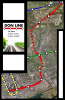
Great looking map and props to you on thinking outside of the conventional thought process behind the DRL routing. Perhaps something of similar nature will be seriously considered by Metrolinx and the TTC but this routing does raise a few issues:
1) Lack of connection to GO Lakeshore line
2) I'm no transit expert but with such a large amount of open air flyovers, bridges and the like, how does this affect maintenance costs given the extreme climates we experience here in Toronto? I'm sure maintenance of such structures will be more costly and time consuming compared to tunnels.
3) Effect on parkland in the Don Valley: Not sure how receptive area residents would be to such a proposal given the reduction of some this prime parkland.
Thanks!
1) I know there are problems with the lack of connection with the Lake Shore line...and for that matter lack of service to Riverdale, Leslieville, and south East York in general. That's one of the biggest drawbacks IMO. In Metrolinx's DRL report a connection station was offered at Gerrard/Carlaw, the same locale where Stintz gave a DRL-infused election speech. However, the distance between this hypothetical Lake Shore line station is only about 1.5km to the Don Line's station at Gerrard/Dundas/River...not too extreme, and there is existing transit connecting the two. As for the Richmond Hill line, a short underground walkway to a Metrolinx-proposed River/Bayview station can easily be achieved.
2) There are three bridges, and one flyover. The southernmost bridge through Riverdale E + W can possibly use an embankment for much of its distance. However, I still firmly believe these pieces of exposed infrastructure would be significantly less to operate/maintain km-for-km than sections of tunnel or cavernous stations. Part of what spurred this idea was the difficulty and costs of tunneling under the Lower Don valley and river. This would involve deep tunnels, deep stations on either side, and probably pumps on standby for any potential flooding. Tunnel infrastructure can always be troublesome in a city like Toronto, where a porous subsurface gives rise to groundwater or road salt penetration; as well as surface undermining and flooding. Operations and maintenance is always an issue when going underground, which this attempts to remedy.
3) NIMBYism and opposition is a potential problem, for sure. But with the exception of a small allocation of Riverdale Park E + W and E.T Seton, much of the Don Valley stretch I don't think is fully classified as park space, rather loosely-labeled green space. Two sections are used by the City as emergency snow dump sites - they're scrubby, polluted, and not for recreational use. However, because of the route taken, significantly less land is lost than if this were to use Richmond Hill line. Any vocal opposition to noise on the surface or portal sections in Cabbagetown, Riverdale, and Leaside would be about on par with the UPX line, perhaps even less so. This can be remedied by noise barriers.
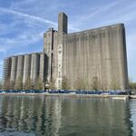
You finally solve the long-standing problem of how to deal with the transit issue to the Brickworks by running an above-ground subway right next to it - allowing for the construction of a very cheap stop. But then you fail to include it on your map, instead creating the longest piece of subway in Toronto without a stop?
The transit issue to the Brickworks was solved, it's an empty bus. I've been on it. It's a small tucked-away park, and there would be no station there. And the distance between Broadview and Laird is 3.1km. This is less than the 3.5km proposed between Kennedy and Lawrence East for a Scarborough Subway. It's sizable, but unlike Scarborough there literally is nothing in between.


 .
.