


Interesting map representation, reaperexpress. One small thing though: Via uses Aldershot, not Burlington. Otherwise great representation, although Stouffville will likely have to be added to that map too, since it's part of both SmartTrack and the GO RER plan.
|
|
|
You are using an out of date browser. It may not display this or other websites correctly.
You should upgrade or use an alternative browser.
You should upgrade or use an alternative browser.
reaperexpress
Senior Member
Interesting map representation, reaperexpress. One small thing though: Via uses Aldershot, not Burlington. Otherwise great representation, although Stouffville will likely have to be added to that map too, since it's part of both SmartTrack and the GO RER plan.
This may be a fairly sedate fantasy map, but it is still a fantasy map. You'll also notice that VIA is not shown to serve Georgetown as it does currently, and that Amtrak serves Hamilton North station, contrary to Metrolinx plans.
The purpose of Aldershot station is to serve both Burlington and Hamilton. But with GO Regional and Amtrak operating out of the new Hamilton North station, it would not need to do so anymore. Relocating to Burlington Station would better serve Burlington itself, thanks to its stronger transit connections and proximity to the city centre.
Stouffville is indeed in my longer-timescale maps, but I don't see any indication that there will be all-day service by 2018. The next line added in my sequence of service maps is the Barrie line, which I include starting in 2020.
When you say interesting map representation are you referring to the idea of represnting each hourly service as a separate line?
I first used that method when I was mapping train service in the Netherlands to decide which city I'd use as my base on my holiday this summer. I would pick one station, and draw all the hourly services departing from it. I found that it was an simple and effective way of displaying portions of complex networks. But the idea is not just mine, I've also seen it in other places such as the East Coast (train operating company) wikipedia article.
Last edited:
nfitz
Superstar
VIA also services Oakville. And Malton.Interesting map representation, reaperexpress. One small thing though: Via uses Aldershot, not Burlington.
reaperexpress
Senior Member
VIA also services Oakville. And Malton.
Exactly.
EDIT: Though looking at the 2016 map I just realized that I actually did forget to put a VIA logo at Brampton station.
Last edited:
reaperexpress
Senior Member
Here is a fantasy map I made to explore the option of building the DRL with mainline rail technology (single-deck high-platform EMUs using Metrolinx's 2x25kv 60hz AC overhead system). It really ended up blurring the lines between commuter rail and metro. The system's centerpiece is a quad-track express/local mainline rail tunnel across the city centre.
(Higher resolution here)
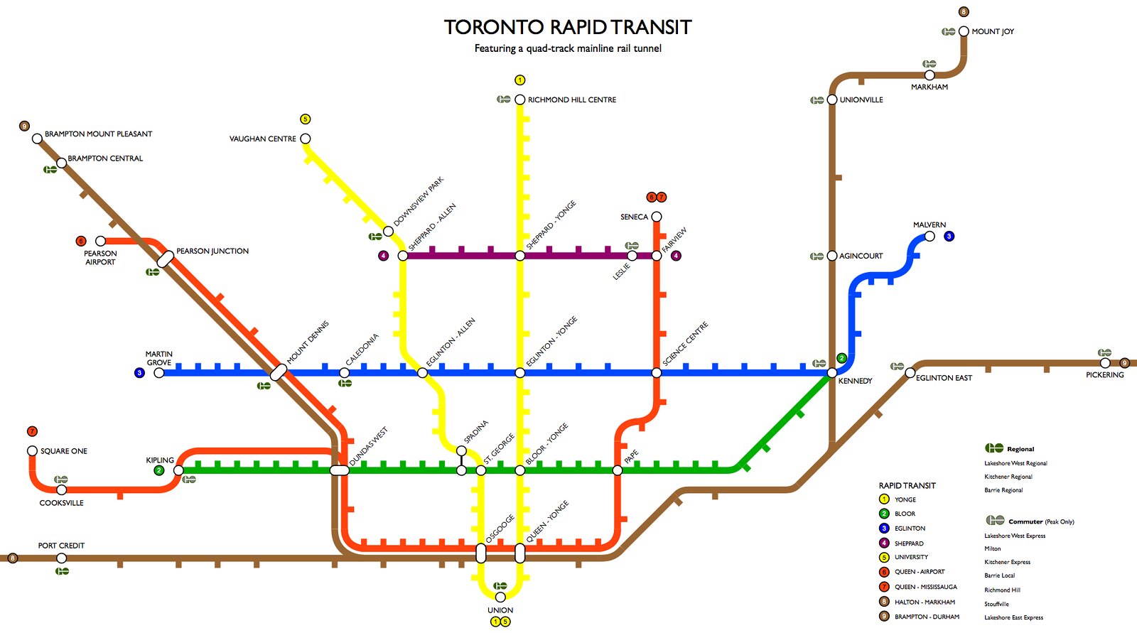
The primary objectives were:
1. To divert passenger loads from Bloor-Yonge station (hence Line 3 going to STC, not Line 2)
2. To divert rail traffic away from the Union Station Rail Corridor
3. To divert passenger loads from the southern Yonge Line
4. To divert passenger loads from the Bloor line between Yonge and Kennedy
In order to have efficient passenger distribution between the services, this design would require a common fare system for TTC and GO. It could potentially have a small premium ($1 or so) for GO services on the basis that they are faster, more comfortable and more attractive for commuters.
An experiment here is that I nominally separated Line 1 - Yonge from Line 5 - University. This helps simplify wayfinding signage and announcements. At Union Station, it would eliminate the confusion currently faced by visitors as to which platform they want. It would help distinguish the two functionally independent halves, especially for the stop announcements on east-west lines. I don't think it's an issue that two "lines" are in fact the same service, given that no one seems to be bothered by this situation existing on Lakeshore West and Lakeshore East lines currently.
Although I started with the normal TTC style map, I ended up moving toward the London Underground style, partly because the London Overground is an real-life example of mainline rail being used as part of a metro system and partly because the map was getting really cluttered.
I kept the lines as simple as possible while still mostly maintaining geographic relativity. For example, Lawrence West, Lawrence, York Heights, and Lawrence East are aligned along Lawrence, and Port Credit, Cooksville and Bramton Central are aligned along Hurontario.
Some details:
Only relatively short-distance and frequent services use the new central tunnel. Longer distance services such as the Kitchener, Barrie and Niagara falls services continue to use Union Station, as do peak-only commuter services such as the Richmond Hill line.
GO Regional services are limited-express services which connect city centres in Southwestern Ontario. They would generally operate at 1-2 trains per hour, all day.
GO Express services are sectional-express services serving commuter demand to the financial district. They are the equivalent to current GO Train service. They would generally operate at 2-4 tph in the peak direction.
Line 3 Eglinton is still LRT, though I envision it having more grade-separation in the east end than currently planned, in order to allow interoperation with the Scarborough LRT.
I have omitted the Finch West and Sheppard East LRTs from the map on the basis that they are not sufficiently rapid.
(Higher resolution here)
The primary objectives were:
1. To divert passenger loads from Bloor-Yonge station (hence Line 3 going to STC, not Line 2)
2. To divert rail traffic away from the Union Station Rail Corridor
3. To divert passenger loads from the southern Yonge Line
4. To divert passenger loads from the Bloor line between Yonge and Kennedy
In order to have efficient passenger distribution between the services, this design would require a common fare system for TTC and GO. It could potentially have a small premium ($1 or so) for GO services on the basis that they are faster, more comfortable and more attractive for commuters.
An experiment here is that I nominally separated Line 1 - Yonge from Line 5 - University. This helps simplify wayfinding signage and announcements. At Union Station, it would eliminate the confusion currently faced by visitors as to which platform they want. It would help distinguish the two functionally independent halves, especially for the stop announcements on east-west lines. I don't think it's an issue that two "lines" are in fact the same service, given that no one seems to be bothered by this situation existing on Lakeshore West and Lakeshore East lines currently.
Although I started with the normal TTC style map, I ended up moving toward the London Underground style, partly because the London Overground is an real-life example of mainline rail being used as part of a metro system and partly because the map was getting really cluttered.
I kept the lines as simple as possible while still mostly maintaining geographic relativity. For example, Lawrence West, Lawrence, York Heights, and Lawrence East are aligned along Lawrence, and Port Credit, Cooksville and Bramton Central are aligned along Hurontario.
Some details:
Only relatively short-distance and frequent services use the new central tunnel. Longer distance services such as the Kitchener, Barrie and Niagara falls services continue to use Union Station, as do peak-only commuter services such as the Richmond Hill line.
GO Regional services are limited-express services which connect city centres in Southwestern Ontario. They would generally operate at 1-2 trains per hour, all day.
GO Express services are sectional-express services serving commuter demand to the financial district. They are the equivalent to current GO Train service. They would generally operate at 2-4 tph in the peak direction.
Line 3 Eglinton is still LRT, though I envision it having more grade-separation in the east end than currently planned, in order to allow interoperation with the Scarborough LRT.
I have omitted the Finch West and Sheppard East LRTs from the map on the basis that they are not sufficiently rapid.
Last edited:
WislaHD
Superstar
So how viable do you guys think a Mt. Pleasant-Jarvis BRT would be?
I'm imagining something that runs between Lawrence Station, along Lawrence, down Mt. Pleasant, hitting ECLRT and B-D before merging onto Jarvis, and connecting with a future SmartTrack/DRL tunneled station at Queen-Jarvis. Perhaps even a minor east-ward extension of the St. Clair streetcar to Mt. Pleasant.
I've always found that the quickest way downtown for me is driving down Mt. Pleasant and Jarvis, even quicker than taking the subway. It generally moves fairly quickly between St. Clair and Jarvis. Putting a form of rapid bus service might actually prove more popular than anticipated and serve to ease congestion on the Yonge subway.
ehlow
Senior Member
So how viable do you guys think a Mt. Pleasant-Jarvis BRT would be?
I'm imagining something that runs between Lawrence Station, along Lawrence, down Mt. Pleasant, hitting ECLRT and B-D before merging onto Jarvis, and connecting with a future SmartTrack/DRL tunneled station at Queen-Jarvis. Perhaps even a minor east-ward extension of the St. Clair streetcar to Mt. Pleasant.
I've always found that the quickest way downtown for me is driving down Mt. Pleasant and Jarvis, even quicker than taking the subway. It generally moves fairly quickly between St. Clair and Jarvis. Putting a form of rapid bus service might actually prove more popular than anticipated and serve to ease congestion on the Yonge subway.
I've been saying this for a while. In fact my first post on this forum I think about a year ago was about this.
I wouldn't even look at BRT right now: just a regular bus line along Mt Pleasant-Jarvis would be useful and fast to try out.
Eliminate the following bus lines: 74 Mt Pleasant, 103 Mt Pleasant North, 141 Mt Pleasant downtown express. 141 is the only one that goes down to Jarvis, but it's extra fare and only a few buses during rush hour.
Use the buses & drivers from the above bus lines. The bus loops is already there in the north, in the south it can loop on the streets near St Lawrence Market.
This provides an alternative to the subway just east of it. This route is very fast because of the nature of the road through Rosedale & St Clair areas, it's one of the fastest roads and can operate pseudo express through some stretches.
Johnny Au
Senior Member
What bus then goes on Mt. Pleasant to Doncliffe if Route 103 is eliminated?I've been saying this for a while. In fact my first post on this forum I think about a year ago was about this.
I wouldn't even look at BRT right now: just a regular bus line along Mt Pleasant-Jarvis would be useful and fast to try out.
Eliminate the following bus lines: 74 Mt Pleasant, 103 Mt Pleasant North, 141 Mt Pleasant downtown express. 141 is the only one that goes down to Jarvis, but it's extra fare and only a few buses during rush hour.
Use the buses & drivers from the above bus lines. The bus loops is already there in the north, in the south it can loop on the streets near St Lawrence Market.
This provides an alternative to the subway just east of it. This route is very fast because of the nature of the road through Rosedale & St Clair areas, it's one of the fastest roads and can operate pseudo express through some stretches.
WislaHD
Superstar
What would be a better northern terminus? Lawrence Station or Doncliffe loop? I chose Lawrence because my understanding is that Lawrence station can handle buses.
Or maybe change 103's southern terminus from Eglinton station to somewhere on Jarvis too. Run two Mt. Pleasant buses, increasing the frequency along the relevant part.
Or maybe change 103's southern terminus from Eglinton station to somewhere on Jarvis too. Run two Mt. Pleasant buses, increasing the frequency along the relevant part.
ehlow
Senior Member
What bus then goes on Mt. Pleasant to Doncliffe if Route 103 is eliminated?
The bus route I just described which combines the 3 current ones. The new one that runs down Mt Pleasant & Jarvis. It runs Doncliffe loop, down Mt Pleasant, which becomes Jarvis.
salsa
Senior Member
When the crosstown opens, I hope they will at least merge both of the Mt Pleasant buses (103 and 74) into one route terminating at St Clair station.
Johnny Au
Senior Member
The new 74 Mt. Pleasant bus should go between St. Clair station and Doncliffe, freeing up the 103 numbering for another route. Oh, and the Lawrence/Mt. Pleasant intersection should be made into a roundabout (even if it means expropriation).When the crosstown opens, I hope they will at least merge both of the Mt Pleasant buses (103 and 74) into one route terminating at St Clair station.
jcam
Active Member
I really like reaperexpress's idea of making the DRL with mainline rail technology.
I'd go a step further to suggest that you could make the Richmond Hill line with a combination of the DRL with a re-routing of the southern end of the line on GO-owned track and new tunnels.
Under downtown, I agree you should tunnel under Wellington to serve the core. Have the tunnel exit around Queen on the Richmond Hill line, then follow the Don Branch of the Bellville sub that Metrolinx purchased (in 2007). Follow the Bellville sub through Leaside Junction along to Eglinton, then tunnel across to Don Mills, then north. North of Lawrence, come above ground and re-join the existing Richmond Hill line.
Make the tunnel capable of handling bi-level trains, like CrossRail in London. This uses a lot of existing surface track, with strategic tunnels. You could build the relief connection to Line 2 at Broadview, with a pedestrian tunnel between the track along the DVP (the Don Branch hugs the DVP). You'd also be able to serve Thorncliffe with a Thorncliffe/Leaside station without having to build a new bridge at Millwood (as you would for a DRL up Pape). Instead you'd widen the bridge over the Brickworks and Metrolinx has just completed a similar project for the Kitchener line crossing the Humber.
Attachments
Last edited:
Yup, the DRL as a component of GO RER in my opinion makes a lot more sense than as a component of the TTC subway network.
I've done a couple tweaks to my GO REX map, including adding the UPX onto it as a sub-set of the GO+ network. As a result, there's a Red Line and a Blue Line service to Pearson. The Red Line is the Toronto-centric GO REX network, using the Central Tunnel (DRL). This is kind of like the Heathrow Express and the Heathrow Connect services, where one is a premium express service and the other is a more local service.
In response to the post above, here's how a GO REX DRL could potentially be incorporated along with the Richmond Hill line.

Link: https://dl.dropboxusercontent.com/u/43869799/GO REX v7.jpg
I've done a couple tweaks to my GO REX map, including adding the UPX onto it as a sub-set of the GO+ network. As a result, there's a Red Line and a Blue Line service to Pearson. The Red Line is the Toronto-centric GO REX network, using the Central Tunnel (DRL). This is kind of like the Heathrow Express and the Heathrow Connect services, where one is a premium express service and the other is a more local service.
In response to the post above, here's how a GO REX DRL could potentially be incorporated along with the Richmond Hill line.
Link: https://dl.dropboxusercontent.com/u/43869799/GO REX v7.jpg
reaperexpress
Senior Member
Yup, the DRL as a component of GO RER in my opinion makes a lot more sense than as a component of the TTC subway network.
I've done a couple tweaks to my GO REX map, including adding the UPX onto it as a sub-set of the GO+ network. As a result, there's a Red Line and a Blue Line service to Pearson. The Red Line is the Toronto-centric GO REX network, using the Central Tunnel (DRL). This is kind of like the Heathrow Express and the Heathrow Connect services, where one is a premium express service and the other is a more local service.
In response to the post above, here's how a GO REX DRL could potentially be incorporated along with the Richmond Hill line.
Link: https://dl.dropboxusercontent.com/u/43869799/GO REX v7.jpg
This is fantastic! I'd played with the idea of extending the DRL along the Metrolinx Bala sub north of Don Mills Centre, but at that point I was thinking in terms of rapid transit technology so the line had to end at Steeles due to the CN traffic. This makes much more sense.
I was also thinking of the Cambridge-Guelph line as a part of the Grand River LRT network, but regional rail makes a lot of sense there too.
Last edited: