News   Apr 26, 2024
 272     0 
News   Apr 25, 2024
 496     0 
News   Apr 25, 2024
 1.5K     4 

Transit Fantasy Maps

Because like along the 512, everyone wants to have a stop within 2 minutes walk, pretending it is for the seniors and handicapped. So a potentially rapid line which could work great end up stopping every 90 seconds and taking forever for anyone to get anywhere.
The proposed Sheppard East spacing is far greater than the 512.
 
^ well that's what comes with LRT. On LRT, you can get off infront of your house. I like the map, but it begs the question why not bring the DRL to don mills. What program did you use to make this?

I wish I knew some magic website that allowed you to draw sophisticated lines on a map, but I just slaved away on Paint.Net for an hour.

Anyway to answer your question, this route is potentially cheaper than DRL to Sheppard and prevents the need to convert Sheppard Subway into LRT.

We could potentially do the same thing with the proposed Jane LRT, have it interline with Eglinton in the west.
That's fair, but a subway would actually pull people off Yonge-University line, with a larger capacity of course. But the interlining option I like. I always thought the Jane LRT could be connected to the crosstown as well. I think it would relieve the Weston buses as well.
Google earth is your friend. Big maps, fast. I can draw out a map like that in 5 minutes. Well, without stop names.

Thanks. Will consider for next time.
 
Because like along the 512, everyone wants to have a stop within 2 minutes walk, pretending it is for the seniors and handicapped. So a potentially rapid line which could work great end up stopping every 90 seconds and taking forever for anyone to get anywhere.

The proposed Sheppard East spacing is far greater than the 512.

How many times have we said that Sheppard & Finch LRTs are faster and have much wider stop spacing than both St Clair and Spadina? At least 5 times I think.

It will probably never sink in. I don't like inaccurate information floating around, but it's probably useless to keep correcting and correcting. I should probably give up.

I wish people would argue against LRT using real facts, which you can do, rather than inaccurate and untrue statements like "they are as slow as the existing bus" "they are as slow as St Clair or Spadina".
 
]5? There was page after page after page of it in 2009 or so ...

Wow so it is really useless.

The thing is, it's pretty easy for anybody to verify. You can just go to google maps, and check existing stop spacing by doing "directions to/from" from one stop to the other. It tells you the distance.

You can do that for existing routes like St Clair or the current Sheppard East bus. Then you do the same thing for the LRT stations to compare.

You can also pretty find the average speeds of routes online, and the average speed in the EAs for the given route.
 
How many times have we said that Sheppard & Finch LRTs are faster and have much wider stop spacing than both St Clair and Spadina? At least 5 times I think.

It will probably never sink in. I don't like inaccurate information floating around, but it's probably useless to keep correcting and correcting. I should probably give up.

I wish people would argue against LRT using real facts, which you can do, rather than inaccurate and untrue statements like "they are as slow as the existing bus" "they are as slow as St Clair or Spadina".

I wasn't implying it would be as slow as st Clair but density along Sheppard is also much lower. So basically both lines have an equal percentage of unnecessary stops. (About 1/3-1/2)
Essentially the spacing shown in the Shepard LRT is about the same as what central Paris or Manhattan's density justifies yet we have it along Sheppard - very suburban built form.

Sometimes I do want a subway there not because it is necessary but because it is the only way to be expensive enough for ttc not to have that crazy number of stops.
 
The Danforth station was dropped basically when De Baeremaeker wanted to reduce the delta between SRT and subway below a specific number.

By the way, this might be interesting to those who have been following GDeB's dreams of a High Line along the SRT structure:
James Corner Field Operations designed the High Line with Diller Scofidio & Renfro. Mr. Corner calls the city around the park its “borrowed landscape.” The inimitability of those surroundings, and the park’s site-specific detailing, are major reasons the so-called High Line effect has been, like the Bilbao one, fool’s gold for so many other cities that have wanted to follow in New York’s footsteps.
 
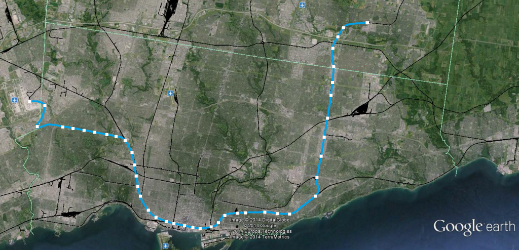
Since no one seems to have done it yet, I've decided to take John Tory's SmartTrack plan graphic and expand upon it using Google Earth, just to show what it realistically could look like:


I've added minor extensions to both ends and added a lot of infill stations to make the line more useful to the communities it passes through. I'll post maps of how the SmartTrack plan would look when included with the other rapid transit lines soon.
 
So I did some work on my transit map which was posted on the DRL thread. Mostly aesthetics, small adjustments, showing a completed line to St Andrew, and the addition of Laird/Millwood station. I have another copy, where in the blank space I included a lot of photographs of similar needed infrastructure. Looked a bit messy though.

View attachment 33757

One reason I wanted to include many images is to show how commonplace and realistic many of my DRL components are - even within Toronto. The UPX and Georgetown South project is of interest because a rebuilt span over the Humber shares a lot of similarities to the Don Valley's Half-Mile Bridge, which forms the basis of my proposal to traverse the valley. Also included were rapid transit flyovers, which would be used to cross over the DVP; as well as concrete viaducts, like currently seen at Old Mill station.

Another project which could be built in conjunction is the Leaside Bypass, where Redway Rd is extended from Millwood to Bayview, offering Leaside residents calmer streets and road network improvements.

Utilizing the abandoned Don Branch corridor seems like a no-brainer; cost and time-savings being the key reason. The Metrolinx proposal of a DRL from St Andrew to Don Mills is 11.9km and costs $5.9bn (2012). A basic measurement of my Don Line comes in at 10.3km, with evident savings offered. Maybe I deluded myself a bit, but it looks promising to me at the moment.

I may have missed something in the DRL thread, but what is the ratio of viaduct to surface to tunnel in the valley? What would we see in, say, Riverdale Park?
 
Here's my fantasy map; nothing that hasn't been done before. Full DRL, full Eglinton, and Scarborough, Yonge, BD west, and Sheppard West extensions. Everywhere else can be LRT/BRT.


And here's my long term, pie-in-the-sky, 100-year-plan idea. 11 lines branching to each suburb, creating a dense inner-city network.

 
Last edited:
Here's my latest GO REX map. The biggest change I made on this map is switching from having the colouring be line-based, to being based on the service type. This means that all main GO REX lines are green, all GO REX Toronto lines are red, and all GO+ lines are blue. I find it's a much easier way to display the various lines, especially coming into Union, which would otherwise be an absolute spaghetti of lines (10 GO lines by my count).

The content of the map is pretty similar to what I've shown on my previous maps, with only a few minor alterations. Some of the changes are:

1) Addition of GO+ branch to Cambridge via the Kitchener line.
2) Addition of Peterborough GO+ line (low priority, but worth showing none the less).
3) Addition of a GO REX line on the Barrie line, allowing for a more express-style GO+ service all the way from Barrie.

Let me know if you have any questions/comments!

GO%20REX%20v7.jpg

Link:https://dl.dropboxusercontent.com/u/43869799/GO REX v7.jpg
 
Last edited:
Here's my latest GO REX map...

Line E21 and E2 are so much better than the Scarborough subway, and could probably be built for the same amount of money from the city. But unfortunately, logic has no place in election-based transit planning.
 
Line E21 and E2 are so much better than the Scarborough subway, and could probably be built for the same amount of money from the city. But unfortunately, logic has no place in election-based transit planning.

Agreed. If that GO REX configuration becomes a reality, the Scarborough Subway becomes completely redundant. And yes, the cost would probably be pretty similar. The Province is paying for all of the E3 GO REX, so really all that needs to be funded using Scarborough Subway funds is from the split to Malvern. The ROW is already there, because it would be the same as for the SLRT.
 

Back
Top