News   May 23, 2024
 287     0 
News   May 23, 2024
 549     7 
News   May 23, 2024
 952     0 

Wikipedia:Toronto

4grand

Active Member
Member Bio
Joined
Jun 13, 2008
Messages
413
Reaction score
4
I've been perusing the site, and it seems that many of the pictures are outdated.

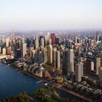
Anyone interested in updating the pics? Skyline, financial district, ACC, etc.?


I'll admit, I'm not technically savvy enough, but I'm sure a lot of you are.

It's our window to the world nowadays, might as well give them a true perspective.

Most, if not all the pictures, don't include the B/A, RBC, and newer City Place buildings. I'm sure we all agree those have made quite an impact.

Thanks!
 
Anybody feel like doing this? I admit, I have no clue where to start, but I'm sure some of you would love to do this.
 
I notice that the article currently provides populations for the City of Toronto (2.5 million) as well as for the Toronto urban area (4.8 million), Toronto CMA (5.1 million), and GTA, also listed as Metro (5.6 million).

I don't really know whether the latter three have any business being in the Toronto article -- it is really about the City of Toronto; for instance, Etobicoke, North York, Scarborough are listed as the "outer suburbs" (local-dial areas bordering those former munis are not mentioned).

However, I am curious. I know the boundaries of the City of Toronto, and think that the GTA is defined to include all of the surrounding regions (Durham, Halton, Peel, York,). But does anyone know what the boundaries of the "Toronto urban area" and "Toronto CMA" are?
 
However, I am curious. I know the boundaries of the City of Toronto, and think that the GTA is defined to include all of the surrounding regions (Durham, Halton, Peel, York,). But does anyone know what the boundaries of the "Toronto urban area" and "Toronto CMA" are?

You're right about the GTA.

GTA: City of Toronto + Regional Municipalities of Halton, Peel, York, and Durham.
GTA_map.gif


CMA: A Census Metropolitan Area is defined primarily by commuting patterns, in order to determine how interconnected/inter-dependent municipalities are in order to create metropolitan regions. Oshawa is also a CMA, and Burlington is part of the Hamilton CMA. Toronto CMA (as of the 2006 census):
torontocma_80.jpg


Urban Area: Defined as having "a minimum population concentration of 1,000 persons and a population density of at least 400 persons per square kilometre, based on the current census population count. All territory outside urban areas is classified as rural."
The long definition, describing how this is determined, can be found here: http://www12.statcan.ca/english/census06/reference/dictionary/geo049a.cfm
I tossed together a quick map of the Toronto Urban Area (as of the 2006 census):
torontoua2zr9.jpg


CMA and Urban Area are Statscan definitions. GTA is not.

The Wikipedia article is using the GTA population as the "Metro" population. This isn't inherently incorrect, but it is misleading.

`
 
Last edited:
First step is to find some images that people don't mind giving up their rights to, to put under wikipedia's license. You might want to talk to the editor(s) of the page before you try to change it.
 
I notice that the article currently provides populations for the City of Toronto (2.5 million) as well as for the Toronto urban area (4.8 million), Toronto CMA (5.1 million), and GTA, also listed as Metro (5.6 million).

I don't really know whether the latter three have any business being in the Toronto article -- it is really about the City of Toronto; for instance, Etobicoke, North York, Scarborough are listed as the "outer suburbs" (local-dial areas bordering those former munis are not mentioned).
CMA populations are shown in pretty much all the articles about Canadian cities, and most major cities in the world have metro populations shown. It gives a more accurate sense of how big a city really is.
 
To have Orangeville counted as as part of Toronto in any shape or form is ridiculous. I've been there. It is not Toronto. It is nowhere near Toronto.
 
To have Orangeville counted as as part of Toronto in any shape or form is ridiculous. I've been there. It is not Toronto. It is nowhere near Toronto.

That's what it is based upon the definition.

How would you propose changing the following framework: Statscan: CMA? Or what other quantitative system do you propose for determining metropolitan areas?
 
CMA and Urban Area are Statscan definitions. GTA is not.

The Wikipedia article is using the GTA population as the "Metro" population. This isn't inherently incorrect, but it is misleading.

I have never seen it laid out like this. Your explanation was pretty helpful; much appreciated.

I read through the Urban Area definition, and looked at the map. Assuming that the Toronto Urban Area only includes contiguous coloured parts, and that the non-contiguous coloured parts are separate UAs -- this seems to follow from the definition, but not quite sure -- I have to say that the UA by far makes the most sense to me. I can understand why it's not widely used: it's a lot less tidy than the GTA definition. The UA cuts across regions, and even across municipalities, which means you can't just aggregate data like you can for munis and for regions. But the GTA just doesn't seem like a very good definition for the actually-existing Toronto. The Toronto UA sprawls more than I would have thought, but far less than the GTA or CMA, and in a way that makes more intuitive sense in some respect. (EDIT: great map you threw together demonstrating the UA: didn't see it first time round.)

I wonder if anyone has ever seen a Toronto local-calling-area map. I know that in the north it extends to the top of Richmond Hill (i.e. Oak Ridges) and stops there, but have no idea how far it goes in other directions. Maybe a map like that would be instructive.

The underlying issue, obviously, is that to me the City of Toronto seems too small, and the GTA too big, to describe Toronto urban life. In my neck of the woods, certainly, Steeles is not a magical boundary -- Willowdale and Thornhill are pretty much interlocked in terms of living patterns. But I'm not sure what the Toronto that captures that looks like.
 
Last edited:
I wonder if anyone has ever seen a Toronto local-calling-area map. I know that in the north it extends to the top of Richmond Hill (i.e. Oak Ridges) and stops there, but have no idea how far it goes in other directions. Maybe a map like that would be instructive.

An interesting idea and I might make one sometime (if there isn't one already out there), but I suspect it would be much larger than you think. A quick Google search informed me that now even the Caledon 519 area (up by Orangeville) is a local call from Toronto.

Speaking of that, it was always strange growing up in the southern edge of Caledon (in the 905 area) that Scarborough was a local call but Mississauaga was long distance.
 
Last edited:
An interesting idea and I might make one sometime (if there isn't one already out there), but I suspect it would be much larger than you think. A quick Google search informed me that now even the Caledon 519 area is a local call.

That is surprising. Note that local calling areas are in reference to a particular exchange, not to a whole area -- Oak Ridges is a local call both to 416 and to Newmarket; parts of Mississauga are a local call both to 416 and points west of Mississauga; but Oak Ridges and those parts of Mississauga are not a local call between them. So it would have to be with reference to a fixed switch -- mobile calling areas are apparently larger, I have heard -- at, say, the Toronto Eglinton exchange or something (for which see list of local calling exchanges here -- no 519).
 
at, say, the Toronto Eglinton exchange or something (for which see list of local calling exchanges here -- no 519).

There are two 519s in that list.

I don't have a map, but I think that most of the 'Town' of Caledon consists of the Georgetown, Snelgrove, Victoria, Caledon East, Bolton, and Palgrave exchanges (all 905). The Caledon exchange only refers to the part of the 'Town' of Caledon within the 519.
 
An interesting idea and I might make one sometime (if there isn't one already out there), but I suspect it would be much larger than you think. A quick Google search informed me that now even the Caledon 519 area (up by Orangeville) is a local call from Toronto.

Speaking of that, it was always strange growing up in the southern edge of Caledon (in the 905 area) that Scarborough was a local call but Mississauaga was long distance.

I knew someone for whom the house on the other side of the street was long distance and a city 45 minute drive away was local.
 
I thought it was crazy that Woodbridge was always a long distance call from Brampton and Bramalea exchanges but that Caledon and Georgetown were not.

This is why 416/647 numbers are generally much more attractive for cellphones - from Toronto, you get the maximum local calling area, even if you are calling from Brampton to Vaughan.
 

Back
Top