News   Apr 17, 2024
 326     0 
News   Apr 17, 2024
 285     0 
News   Apr 17, 2024
 1.7K     1 

Bond Ave, North York, Railway Subway - date?

donoreo

Active Member
Member Bio
Joined
Dec 2, 2009
Messages
273
Reaction score
19
Location
Don Mills
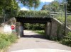
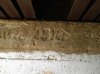
The railway does not go over it now, the space is a bike and walking path. However the subway on Bond is still there. I was just there the other day and the date looks like 1913 on it. That did not seem correct as I do not think there was anything there in 1913.

IMG_1769.jpg
IMG_1771.jpg
Does anyone have any info on when this would have been built?
 

Attachments

  • IMG_1769.jpg
    IMG_1769.jpg
    63.6 KB · Views: 849
  • IMG_1771.jpg
    IMG_1771.jpg
    53.2 KB · Views: 801
that's the CN Oriole Spur, built in 1917, opened in 1918
The CNoR needed bigger facilities for Toronto so it built new shops (opened 1919) at Leaside including an erecting shop for locomotives, a coach shop and a (freight) car shop. A small yard was also built. In order to get access to this property it had to build a connection from the Bala line south to Leaside. The line up the Don through Rosedale climbs a grade, crossing well below the CPR before reaching higher land near Oriole. Here a connection was built for southward to westward (or east to north) movements to Donlands (2.2 miles) where it connected with the CPR to reach Leaside another 1.3 miles and completed in June 1917 although it did not go into operation until February 1, 1918 likely held up reaching agreement on terms and conditions.
-- http://www.trainweb.org/oldtimetrains/CPR_Toronto/NORTH_TORONTO.htm
 
I did not post that I knew the spur, that is not important. Bond Ave should not have been there in 1918 so it does not make sense for the structure to be there. I am trying to find out why it was built.
 
No, not a creek. The dotted line is now Bond Ave. I assume the dotted line means it wasn't a full-fledged road, but there was some sort of road there that required a subway over it. If you look at the same topographic map for 1909, Bond Ave is there but the spur isn't. It looks as if the road also extended east of Don Mills road to access a 'GM' which I think means grist mill. There was another road north of there that also went into the valley - now it's a service road for Donalda golf course.
 
No, not a creek. The dotted line is now Bond Ave. I assume the dotted line means it wasn't a full-fledged road, but there was some sort of road there that required a subway over it. If you look at the same topographic map for 1909, Bond Ave is there but the spur isn't. It looks as if the road also extended east of Don Mills road to access a 'GM' which I think means grist mill. There was another road north of there that also went into the valley - now it's a service road for Donalda golf course.
Either way makes sense. I just looked at a few different sources including the map you showed. ( I have a clearer version of it on my local computer)
If you follow the rail lines on Google it appears that the bridge is a little further south than that dotted road. But again, either explanation works!

Zoom in on this one!
http://library.mcmaster.ca/maps/airphotos/zoom/1954-1955_436792.htm
 
Last edited:
Either way makes sense. I just looked at a few different sources including the map you showed. ( I have a clearer version of it on my local computer)
If you follow the rail lines on Google it appears that the bridge is a little further south than that dotted road. But again, either explanation works!

Zoom in on this one!
http://library.mcmaster.ca/maps/airphotos/zoom/1954-1955_436792.htm

Nice!

The 1918 topo map I posted was a bit fuzzy and unfortunately Bond Ave is right at the top. Maybe one of the conditions Mr Bond attached to putting the rail spur on his land was that they build a bridge over his lane so he could get to the back 40. And maybe it was a 'subway' and not a bridge because of the topography.

This topo map from 1950 shows it a bit clearer. According to the legend, a double-dashed road means 'Other roads, poor condition'.
1950.jpg


And just for fun, here's a snip from the Master Plan of Don Mills, dated 1953
1953.jpg
 

Attachments

  • 1950.jpg
    1950.jpg
    93 KB · Views: 1,102
  • 1953.jpg
    1953.jpg
    100.2 KB · Views: 1,006
This topo map from 1950 shows it a bit clearer. According to the legend, a double-dashed road means 'Other roads, poor condition'.
View attachment 16775

Interesting maps for close study - thanks Anna.
That "Golf Course" in the 1950 map would become the IBM Country Club in the early 1950s.
 
Way back when the railways were brand new there must have been some sort of requirement for them to make their right of way (when elevated on an embankment) less of a barrier to others. Examples of underpasses where no reason seems to exist are not hard to find even 150 years later.
 
Nice!

The 1918 topo map I posted was a bit fuzzy and unfortunately Bond Ave is right at the top. Maybe one of the conditions Mr Bond attached to putting the rail spur on his land was that they build a bridge over his lane so he could get to the back 40. And maybe it was a 'subway' and not a bridge because of the topography.

This topo map from 1950 shows it a bit clearer. According to the legend, a double-dashed road means 'Other roads, poor condition'.
View attachment 16775

And just for fun, here's a snip from the Master Plan of Don Mills, dated 1953
View attachment 16776
Anna you are great! Where did you get the master plan of Don Mills? I would like to see more! So the map here shows much better that the bridge/subway was there over a road. Too bad Bond does not go through to Don Mills Rd, it would be nice to have another route to Leslie.
 
Anna you are great! Where did you get the master plan of Don Mills? I would like to see more! So the map here shows much better that the bridge/subway was there over a road. Too bad Bond does not go through to Don Mills Rd, it would be nice to have another route to Leslie.

Nice, isn't it...The UofT map site.
http://maps.library.utoronto.ca/cgi-bin/files.pl?idnum=1385

I wouldn't mind if the road just south of the golf course was there too.
 
that's the CN Oriole Spur, built in 1917, opened in 1918
I just reread my earlier reply, I could have come across as kind of snarky. I certainly did not meant it that way. If anything I was being a lazy typist. Apologies if it came out wrong.
 

Back
Top