News   Apr 16, 2024
 375     2 
News   Apr 16, 2024
 391     1 
News   Apr 16, 2024
 750     0 

Vancouver's 30-year transportation plan: heavy on walking, light on cars

M II A II R II K

Senior Member
Member Bio
Joined
Apr 24, 2007
Messages
3,944
Reaction score
1,061
Vancouver's 30-year transportation plan: heavy on walking, light on cars


June 18, 2012

By Mike Aynsley

openfile_logo_2011.gif


Read More: http://www.openfile.ca/vancouver/bl...-transportation-plan-heavy-walking-light-cars


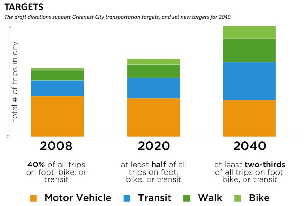
The City of Vancouver has just released the updated version of its transportation plan looking into the year 2040. As you would expect from a city that says active transportation is its top transportation priority, walking, cycling, and public transit figure into the plan quite prominently.

- Other priorities outlined in the document include: improve pedestrian safety, promote walking, make streets and public areas “rain-friendly†(this would entail things like installing more awnings in commercial areas), create more public spaces, promote cycling, reduce bike theft, and promote and improve transit. The plan makes no mention of building new roads or installing more parking for cars. In fact, the section on cars states states the goal is to manage the road network efficiently to improve safety and support a gradual reduction in car dependence. Make it easier to drive less. Accelerate the shift to low carbon vehicles.

- The plan does state, however, that the city will work to improve traffic signal timing and rush hour management. As far as parking is concerned, the idea is to reduce the need for it while making it easier to find available spaces. The proposal states a lot of traffic is the result of drivers cruising around in search of an available parking space—which accounts for up to 40 per cent of traffic in some cities. The city can reduce congestion, support local businesses, and increase customer convenience by providing drivers with better information on available spaces, and by setting on-street prices to ensure a limited number of on-street spaces are always available. New and emerging technologies will continue to make this easier.

.....


7396490980_deabe4a856_b.jpg
 
Are we getting left behind as a major Canadian city, or will Metrolinx's projects, the city's bikeway initiative, and new density in walkable, mixed-use neighbourhoods put us on a similar trajectory? It's critical that Canada's largest city leads, and if there are any obstacles to that, we need to address and remove them.
 
Right now, we are on the right track. I would be seriously concerned if hudak got elected though. It would not surprise me if he got rid of the greenbelt, and said srew it to any currently unfunded big move 2020 proposals.
 
It's not like Ontario has a shortage of space to feel the need of getting rid of green spaces.

40% for Vancouver at this time is quite impressive.
 
I personally would love to become only the second city in canada and the US that has a majority of people NOT owning a car.. new york currently is the only one, with 54% of new yorkers not owning one.
 
I personally would love to become only the second city in canada and the US that has a majority of people NOT owning a car.. new york currently is the only one, with 54% of new yorkers not owning one.

54% not owning a car seems very high for a city where less than 25% take public transit.

Perhaps that stat was just for Manhattan?
 
Vancouver has many faults but I'll give it one thing..........when they make plans for transit expansion they follow thru on them. Vancouver {and Calgary} have excellent record of building mass/rapid transit on time and on budget while Toronto excels at studying transit and when finally getting around to building something the prices are astronomical.
 
NYC metropolitan area is around 25%. For city proper it is much higher.

In comparison, TO is around 22%.

I'm guessing stats in OP is for City of Vancouver only, not Vancouver CMA.
 
NYC metropolitan area is around 25%. For city proper it is much higher.

In comparison, TO is around 22%.

I'm guessing stats in OP is for City of Vancouver only, not Vancouver CMA.

is it possible that you are speaking of household ownership? i.e. 25% of households don't own a car, or are you talking about people over the age of 16 owning a car? it wouldn't surprise me if you are speaking per household, while this 54% number comes from individuals.
 
^ I was just respond to discussion of transit mode share. NYC's 25% is work trips by transit and that's for the entire metropolitan area, not just NYC proper.
 
54% not owning a car seems very high for a city where less than 25% take public transit.

Perhaps that stat was just for Manhattan?

IIRC, Queens and Staten Island are the only boroughs where the majority of households own a car.

As for comparing the modal split in Vancouver vs. Toronto, bear in mind that Vancouver proper is relatively small (~600,000 people). Does anyone have an idea what the modal split in the old City of Toronto looks like?
 
As for comparing the modal split in Vancouver vs. Toronto, bear in mind that Vancouver proper is relatively small (~600,000 people). Does anyone have an idea what the modal split in the old City of Toronto looks like?

Why would you restrict to an artificial municipality boundary? Surely we should be comparing Urban Areas of similar density or built form.

There is a really good reason why the census provides information in tracts; it's so you can put together reasonable comparisons.


Would you really compare the Municipality of Toronto 15 years ago to another city like Calgary or Ottawa (which have massive boundaries) and believe your results were accurate? Would you believe that Toronto became massively more suburban between 1997 and 1999? Of course not; which is why using municipal boundaries is junk data. Garbage in, garbage out.

Obviously, for a number like modal split, you need to use the metropolitan or urban area.
 
Last edited:
Why would you restrict to an artificial municipality boundary? Surely we should be comparing Urban Areas of similar density or built form.

[...]

Obviously, for a number like modal split, you need to use the metropolitan or urban area.

Of course, if we were starting from scratch, best practice would be to use the metropolitan or urban area, but we're not starting from scratch; we're discussing the numbers in the City of Vancouver's plan. The arbitrary municipal boundary has already been chosen for us. In that context, the old City of Toronto appears to be a better comparison than the entire megacity. I think that's all lesouris is saying.
 
Car ownership rates are a bad indicator of a city's transit progressivism. The US city with the second lowest car ownership rate is Newark, NJ where 45% of households don't own a car. Of course, this is not because transit is so great in Newark that people can voluntarily give up their cars, but because the majority of the people who live in Newark are desperately poor and cannot afford a car. To underscore this, Detroit is among the "top" 20 US cities for households without a car (22% of households), but we all know that Detroit is not really a walkable, transit-friendly city.

I fear that Toronto will become a city where the majority of households won't own a car but for exactly the wrong reasons: it's not because transit service will improve or because the walkable, urban fabric will be extended out past where it now peters ou. It'll be because the inner suburbs will get poorer and more marginalized and housing costs will rise to the point where a significant number of suburbanites (more than already do) will have to choose between shelter and a car. Given this choice, they will almost always pick shelter.
 

Back
Top