News   Apr 19, 2024
 2K     1 
News   Apr 19, 2024
 913     3 
News   Apr 19, 2024
 1.4K     3 

Toronto's Off-Road bike paths

Northern Light

Superstar
Member Bio
Joined
May 20, 2007
Messages
31,721
Reaction score
88,751
Location
Toronto/EY
Many of you will know by now that Toronto is in the process of building more new bike trails this year than in any single year, ever!

Coming in 2011 (now or soon to be under construction)

Finch Hydro Corridor, 2 sections, Yonge, west Dufferin, and one in Scarborough
Gatineau Hydro Corridor (Vic Park to Kennedy) and again from Midland east.
CN Leaside spur (the old leaside spur) roughly parallel to Leslie from just north of Eglinton to York Mills
East Don Valley - Milne Hollow (Lawrence) to Wynford Drive

Also work on the Waterfront Trail in Scarborough from Rouge Hill GO Stn to Pickering continues.

********

So what else does Toronto need in this area? What should its priorities be?

My list includes:

1) The Humber Gap (the missing section of trail near Sheppard)
2) The West Don (Earl Bales to Hogg's Hollow, alongside the Golf Course)
3) Highland Creek Trail from Morningside Park to the Scarborough City Centre Area (where the creek crosses Progress)
4) Finishing the Finch Corridor
5) The Waterfront Trail in Scarborough, below the Bluffs from Bluffer's Park to East Point Park

Any thoughts? Other areas you'd like to see covered?

Don't forget to share your priorities with your City Councillor (or candidates for that office) in your ward!
 
Just try to get from the (T75) Martin Goodman Trial (Lake Shore) to the (W32) South Humber Trail. It's hilly and instead of following the river, it uses a mix of roads and off-road trails.

The W32 South Humber Trial itself has a breaks at Old Mill and at Old Dundas Street.
 
The short on-(small) street portion from Victoria Park Avenue to Pharmacy and south to Warden Woods and then to Warden is in need of signage. Ideally the on-street gap would be made into a marked bike lane. It goes a little further east too, from the bike map but I have not found that bit yet.

In short, efforts should be made to link up existing paths or, at least, to signing the links.
 
My priority is finishing the West Toronto Railpath because its proposed route is dense and full of destinations and it goes through a walkable area with easy connections to the street and without any hills. It's well used already, but it could be very busy when it's completed.

Finishing the Humber Trail at Weston and Church would be great because it's the most inconvenient break in the Humber River trail. To clarify, users are forced to climb a hill to Weston Road at Church Street, and then travel along Weston Road for a bit and a small side street. There isn't even any signage and the sidewalk is very narrow. Apparently, the city is working on it.

Also in terms of the Humber River trail, that narrow bridge just north of Dundas should be replaced with a wider and safer bridge so that cyclists could ride without officially having to dismount.
 
Also in terms of the Humber River trail, that narrow bridge just north of Dundas should be replaced with a wider and safer bridge so that cyclists could ride without officially having to dismount.

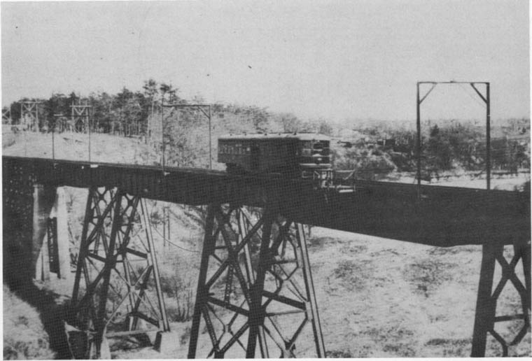
The existing bridge reuses old radial-line piers, doesn't it? Don't know where there's some environmental/Humber-heritage argument against something so-called wider/safer here.

I'm also wondering whether a resurrected Old Dundas bridge (ped/bike-only, of course) is feasible...
 
Then of course there is the quite short but unpleasant on-road section of the Martin Goodman from the new bridge on Unwin Avenue to the improved trail on Leslie at the main gate of Tommy Thompson Park. There are plans to bring an off-road path straight through from the bridge into the Park but I do not know if this is going to happen soon, I think it is under Waterfront Toronto.
 
The existing bridge reuses old radial-line piers, doesn't it? Don't know where there's some environmental/Humber-heritage argument against something so-called wider/safer here.

I'm also wondering whether a resurrected Old Dundas bridge (ped/bike-only, of course) is feasible...

Old Dundas Street bridge was in use until it was washed away, but never rebuilt. Old Dundas Street just ends on both sides of the river.
IMG_9185.JPG

Bicyclists have to detour to a side-street to Old Dundas Street before continuing north.

The old radial piers were similar to this viaduct.
humber-bridge_radial-car.jpg

The right-of-way is now used by the hydro electric lines. The piers over the Humber are narrow, but most bicycles attempt to ride over it.
IMG_9183.JPG

There is room for a wider bridge, but the powers-that-be have in their wisdom decided otherwise.
humberdundasbridge.jpg
 
I've recently seen videos extolling the apparent progressiveness of Bogota, Amsterdam, and New Delhi (and others) because of their well-developed off-road bike paths. The videos went on about how such facilities allow for social justice because they show that those cities are willing to commit facilities to bicycles, and not just wedge them in with automobile traffic, allowing more of a cycling culture to develop. Seeing how I've heard Torontonians condemn off-road bike paths as an apparent plan to push cyclists out of the way of cars, I can't help but laugh at how different perspectives result in different conclusions.

Anyway, Toronto does have a decent network of existing off-road paths. Not amazing, and with lots of room for improvement, but undeniably useful when getting around town by bicycle and extremely well-used. It's embarrassing how many of them have been left to degrade into poor condition. Dug up by construction and tree roots, full of blind and hairpin turns, containing unsafe road crossings, and lacking in clear signage WAAAAAAAAAAY too often, these trails need some serious love and maintenance. We simply would not tolerate the same standards for our roads as we do for our bike facilities.

I'm honestly tempted to start of a "Guerilla Bike Trail Maintenace" team. Toronto's mountain bikers have independently developed a network of trails in the Don Valley, perhaps it's time for non-mountain bikers to invest some time as well. Cut back some weeds, fill in some potholes, and most of all... spraypaint some directions onto the asphalt so people don't get lost so often at the multitude of mysterious forks and gaps in the trails. Some warnings so that cyclists know to take it slow because of the hairpin curve at the bottom of a hill (and the mud at the side of the path makes it clear that many people have failed to make the turn and have gone into the bushes) would be useful as well.
 
I've been doing the Leslie Spit ride on my bike a lot recently, and it's great, but yesterday there were at least a half dozen cars on the main road. Where are they going? Are cars allowed in if they're going to that sailing club? Do they have special access or something?
 
After (perhaps if) this year's projects are done, it would be nice to connect the Leaside trail to Betty Sutherland, the Gatineau trail to the Lower Don, and (much harder) the Finch trail to the Humber. Then and only then should anybody be talking about a bike lane moratorium IMO.
 
Our trails are well-used and can certainly be improved to be more functional, but the geography works against them for utilitarian cycling like commuting. The Don and Humber trails, for instance, tend to be more isolated from destinations and the street grid itself. Nonetheless, they should be part of a strategy to get more people cycling but not the only part, as some bike lane reactionaries would like them to be.
 
Our trails are well-used and can certainly be improved to be more functional, but the geography works against them for utilitarian cycling like commuting. The Don and Humber trails, for instance, tend to be more isolated from destinations and the street grid itself.

Isolated from the street grid today yes, but I do think off-road paths have great potential to serve cycling commuters. I regularly use the Don Trail between downtown and Scarborough - great, except at Bayview and north of Lawrence. I know folks who commute daily from Etobicoke via the Humber, together with the Eglinton and Annette lanes.

The 2009 cycling survey says that the proportion of people who sometimes bike to work has doubled in the last 10 years in the outer boroughs, much more than in the old city of Toronto. Among these people, 64% identify more off-road paths as something that would "improve cycling a great deal" - compared to 59% who said this about more on-street lanes.

Of course, we need both.
 
For a bicycle trail or path to be designed well for bicycles, they should have:
  • wide lanes
  • little or no hills, but if required then gentle inclines
  • no hairpin turns or curves
  • bollards should be spaced wide
  • no mistaken pathways for pedestrians or bicycles
  • bicycle repair shops close by or gas stations with air pumps
  • refreshments or restaurants close by or along the way
  • washrooms available along the way
  • water fountains
  • benches off the path but close by in the shade, rest stops
  • plenty of bicycle posts
  • YIELD signs, not STOP signs
  • dismounting not allowed
  • no barriers
  • no detours because of obstacles
 

Back
Top