


micheal_can
Senior Member
If that is the case, the 413 wont do anything either.The fact that the 407 needs to be tolled at such a high rate to be gridlock free is a sign of the latent demand to begin with.
|
|
|
If that is the case, the 413 wont do anything either.The fact that the 407 needs to be tolled at such a high rate to be gridlock free is a sign of the latent demand to begin with.
Barrie
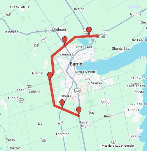
This concept envisions a full grade-separated freeway network through the Barrie area. There are not many significant changes along the HWY 400 corridor with the exception of interchange redesigns as part of the widening along that corridor, and the reconfiguriation of the HWY 400/HWY 11 interchange to make HWY 400 a continuous road, opposite of what exists currently. The major changes in the network are a realignment for a new HWY 11 corridor through Oro-Medonte running south of the existing road, in additon to a new HWY 26 corridor through Essa and Clearview, following the corridor of HWY 90 with some new alignments closer to Barrie and past Angus/Borden. I know MTO has made plans for the HWY 11 corridor, but I could not find any associated study documents for this road segment, which have likely been lost to time. I was also originally planning on running the new HWY 26 corridor up and around western Barrie through Springwater and Midhurst to follow more of the existing HWY 26 corridor, but this was too complicated. Everything in the network would be twinned to a freeway standard. This also includes new road realignments, service roads, and connecting roads. Interchange locations (19) are as follows:
*For the Bayfield Street interchange, MTO is currently planning on reconstructing this but it there does not seem to be a design available yet, so I made a conceptual one.
- HWY 11 and Line 11 (existing, conceptual upgrade)
- HWY 11 and Line 5 (conceptual)
- HWY 11 and Penetanguishene Road (existing, conceptual upgrade)
- HWY 11 and HWY 400 (existing, conceptual upgrade)
- HWY 400 and Forbes Road (existing)
- HWY 400 and Duckworth Street (existing)
- HWY 400 and Bayfield Street (exsiting, conceptual upgrade)*
- HWY 400 and Dunlop Street West (existing, under construction/upgrade)
- HWY 400 and HWY 26 New Alignment (conceptual)
- HWY 400 and Essa Road (existing, under construction/upgrade)
- HWY 400 and Mapleview Drive West (existing)
- HWY 400 and Innisfil Beach Road (existing, under construction/upgrade)
- HWY 26 New Alignment and Miller Drive (conceptual)
- HWY 26 New Alignment and George Johnston Road/10th Line (conceptual)
- HWY 26 New Alignment and Baldwick Lane (conceptual)
- HWY 26 New Alignment and McKinnon Road (conceptual)
- HWY 26 New Alignment and Brentwood Road/Sunnidale Tosorontio Townline (conceptual)
- HWY 26 New Alignment and CR 9 (conceptual)
- HWY 26 New Alignment and Old HWY 26 (conceptual)
View attachment 561411
Well, it's already an undivided 4-lane between Barrie and Angus and divided north of Mosley St. at Wasaga Beach. They would need to bypass Stayner to accommodate any kind of volume.I've had a similar route of a Barrie - Collingwood highway in my head for a while, routing via Angus. Not sure it really needs to be a full freeway though, especially north of Angus. Could probably operate fine as an at-grade, dual carriageway road like Highway 3 between Essex and Leamington. It would probably want to be a freeway between Angus and Barrie and around Collingwood itself, though.
As an FYI, my understanding is that MTO plans to reroute 11 just to the north, not to the south, of the existing alignment at some point when it's upgraded to a full, 6 lane freeway.
The problem is that a lot of traffic on the highway will be people going between Barrie and Collingwood itself - diverting it to the south will miss all those trips.Yeah, I'd want to divert as much traffic from Barrie as possible, meaning that a Highway 26 diversion should join the 400 somewhere between Innisfil Beach Road and Mapleview.
yes, but it's a 4-lane regional road through there.Well, it's already an undivided 4-lane between Barrie and Angus and divided north of Mosley St. at Wasaga Beach. They would need to bypass Stayner to accommodate any kind of volume.
Honestly I disagree. One of the things I like about each province having their own highway signage is it lets each province have an independent character when it comes to highways. Different signage, numbering rules, styles let the provinces express themselves in their own unique way, and overall makes travelling Canada far more interesting.One can only dream of a unified national highway signage in canada.
I would like to add a Barrie Bypass.
Honestly I disagree. One of the things I like about each province having their own highway signage is it lets each province have an independent character when it comes to highways. Different signage, numbering rules, styles let the provinces express themselves in their own unique way, and overall makes travelling Canada far more interesting.
So, connect to an extended 410?I'd have a Barrie "bypass" travel roughly SW to somewhere around Kitchener/Guelph. With the idea being that it would allow for travel from northern Ontario to sw Ontario without entering the GTA. Particularly for transport trucks.
We just don't have any unified highway standards across Canada. Whether that be divided highways with at grade intersections in the west, full freeways in Ontario/Quebec, or super twos in the east, it is hard to have a unified system when quality and design standards vary significantly from province to province. The Interstate system does have unified standards from coast to coast, so it is easy to know what you are signing.I find the current hodgepodge of provincial highway designs to be annoying on long road trips since the road configuration keeps changing. It's hard to know how much time it will take to cover a certain distance or how demanding the driving will be.
Freeways are typically less stressful to drive on than two-lane undivided highways with passing in the lane for oncoming traffic. With national freeway systems like the Interstate, you know you're going to get a grade-separated freeway with dual carriageways with a minimum of two lanes in each direction and a rural speed limit of at least 65 mph.
It's easier to estimate driving times, it's less stressful to drive long distances, it's faster, and it's safer to have freeways from coast to coast. It encourages people to get out and drive around the country and to move to other places in the country besides the three largest cities. It's bizarre that in Canada we neither have a national freeway system, a high-quality intercity railway system, or even a well-subsidized airport network. What exactly are our priorities for transportation and developing the country?
Honestly I disagree. One of the things I like about each province having their own highway signage is it lets each province have an independent character when it comes to highways. Different signage, numbering rules, styles let the provinces express themselves in their own unique way, and overall makes travelling Canada far more interesting.

