


Juan_Lennon416
Senior Member
Majority of people (including those who drive) welcome this reconfiguration! About time this problem is being fixed!
|
|
|
Considering that Gardiner East was justified based on 2-3 minutes of potential delays, this must be of a staggering magnitude locally.
Does anyone have a link to that study? That 36 second stat does sound optimistic.
Councillor Campbell: "It changes a traffic configuration that works and inserts traffic jamming traffic lights. It's a missed opportunity for innovative flow."
For elected officials to then decry essentially 15 years of professional work is just par for the course to slam professional expertise in favour of virtual lived experiences of "real people". I suppose they can also get Eric Miller at U of T to do another Smart Track style report for hire, to announce an additional 30 minutes each way of traffic apocalypse, for the icing on the cake.
Campbell and Di Ciano have been pretty proactive in their community newsletters to let people know this is coming. Neither has presented this project in terms of alarm nor have they done any grass roots rabble rousing with a serious intent of stalling it - imagine if this were in GDB's ward, or even Mammo's.
- Paul
"It changes a traffic configuration that works and inserts traffic jamming traffic lights. It's a missed opportunity for innovative flow."
Maybe the press was just looking for a soundbite and we don't know the whole context. Maybe he's frustrated to not have paradigm-shifting road designs for flying cars or elevated bicycle lanes?
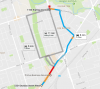
These Google Map suggestions are totally whacked.I think it depends. Because for certain vehicle movements the existing interchange is less than ideal either. For example:
These Google Map suggestions are totally whacked.
Eastbound Dundas to northbound Kipling
View attachment 103805
In this case, you wouldn't do any of these; the main route and alternative are all patently ridiculous. Currently, you take the ramp for Kipling southbound and where it splits you head down the service road, cross under the bridge, then merge on to Kipling northbound via the slip ramp. Simple!
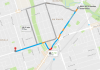
Bloor, in either direction
View attachment 103806
For Bloor eastbound you go all the way to Kipling, turn south onto Kipling, then take the first loop ramp after the bridge, and you're right back on Bloor.
For Bloor westbound, you do take Aukland — it's just that it's showing Jopling, not Aukland. Fail.
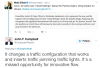
Dundas to Bloor, in either direction
View attachment 103807
For Dundas westbound to Bloor westbound, you turn right onto Aukland and left at Bloor. Pretty simple, but again, Google is showing Jopling. Why?
For Bloor eastbound to Dundas eastbound, you follow the same route I described above to Bloor eastbound, it's just that when you merge at the end of the loop ramp you have to get two lanes left quickly. If you don't like that you continue to Dunbloor and turn left on it to get up to Dundas.
In no case for either of these would you take Aukland south to Dundas and turn left, exactly because of the line-up of cars heading to Kipling station as shown in the last image in @salsa's post.
It leaves me wondering why Google Maps is so poorly programmed for this interchange: it's a complete misunderstanding of of the Six Points works.
42