Toronto Lower Don Lands Redevelopment | ?m | ?s | Waterfront Toronto

So the media package for the revised plan is available on the WT site

First they whittled down the park land to cram in more condos. Now they are putting off the park entirely for about 30 years, until all the condos are built.

Hard not to think there is something wrong with us, as a city and a society. We can spend billions every year on private sector developments, but we can't borrow $500 million for a few years to build this first class public space. Truly I despair.

7743582268_b22bc5e690_c.jpg
 
Last edited:
Waterfront Toronto will look to private sector to fund redevelopment of Port Lands

Waterfront Toronto will be looking to the private sector to help fund its 30-year, $1.9-billion plan to redevelop the derelict waterfront in the Port Lands.

Building on the existing work done in relation to the development of the project, deputy city manager John Livey said they focused on coming up with a business model to fund the project without relying on public funding.

More.........http://news.nationalpost.com/2012/0...e-sector-to-fund-redevelopment-of-port-lands/
 
So the media package for the revised plan is available on the WT site

First they whittled down the park land to cram in more condos. Now they are putting off the park entirely for about 30 years, until all the condos are built.

Hard not to think there is something wrong with us, as a city and a society. We can spend billions every year on private sector developments, but we can't borrow $500 million for a few years to build this first class public space. Truly I despair.

7743582268_b22bc5e690_c.jpg

I don't mean to sound pedantic, but it's not accurate to say that a park is not planned to be built for 30 years until "all the condos are built". I was at the public meeting tonight and it was plainly stated that parks would be constructed in each phase.

In phase one, you'll notice a dark green "c" surrounding a pink box on Cousins Quay. The pink box represents a precinct that has been taken out of the flood zone by initial flood protection work (the lighter green strip running down the west side of the Don Roadway). The green "c" is a public park surrounding the precinct. Furthermore, the flood protection work is essentially a park/greenspace similar to the southern outlet presented in the original MVVA plan.

In phase three, the river and surrounding park leading into the channel between Cousins and Polson Quay is constructed. This is a significant amount of parkland on par with that surrounding the original MVVA plan. It is only after phase three that all of the Lower Don Lands is out of the flood zone and thus can be developed.

Thus, it is not possible that a park will not be built before all development is complete.

The presentation (both the powerpoint and the webcast) will be on the consultation website (portlandsconsultation.ca) tomorrow, and will have much more information that what I've relayed here.
 
Don't buy the spin. A spillway that is due to be flooded will not be built as parkland. It will be waste ground surrounded by industrial sites.
 
Don't buy the spin. A spillway that is due to be flooded will not be built as parkland. It will be waste ground surrounded by industrial sites.

First off, I think there are a lot of important elements to this plan that still need lots of public oversight/discussion. That being said, having been to all of the public meetings in this process, I think the new river option does a pretty good job of maintaining most of the key elements of the original design while providing some thinking on how to fund and implement it.

As for the spillway - it's due to be flooded only in 100 year storm events - i.e. Hurricane Hazel-type storms. While I'm sure that because it is a flood plain, the types of park uses might be limited, I haven't heard anything that would indicate that it can't be used as park-like green space. In fact, Michael Van Valkenberg stated during his presentation that his firm has a lot of experience designing functional park spaces in flood spillways. A local example of this would be the MVVA designed Don River park - the wet side (where flooding would occur) will be a park-like space, with the Don River bike trail continuing to run alongside the river. Of course the wet side will be quite different than the dry side, however I wouldn't describe the ultimate end state as a waste land.

I think there are a lot of instances of shitty compromises in design and planning in Toronto, I just don't think this particular element of the Port Lands plan is one of them.
 
It looks fine - not as ambitious (perhaps dramatic is a better word) as the original proposal but enough of the elements survived to warrant continued support IMO. Quite frankly if this had happened during the original EA process we wouldn't have made much noise about this updated plan. Totally agree with 416 - a shitty compromise in design would be settling with widening/ "naturalizing" Keating Channel and call it a day; building a new river channel isn't it.

A spillway that is due to be flooded will not be built as parkland. It will be waste ground surrounded by industrial sites.

How is it different from the spillway proposed in the original plan - in the sense that one can be parkland and the other wasteground by the mere difference in location?

Star: http://www.thestar.com/news/gta/art...s-development-proposal-looks-pretty-darn-good
Globe: http://www.theglobeandmail.com/news...ization-plan-to-take-30-years/article4470796/

AoD
 
Last edited:
From the Star:
http://www.thestar.com/news/gta/art...s-development-proposal-looks-pretty-darn-good

Port Lands development proposal looks ‘pretty darn good’
Patty Winsa
Urban Affairs Reporter


After dodging a proposal that would have turned the Port Lands into a carnival sideshow, development of the massive parcel of land is back on track.

Waterfront Toronto and the city unveiled the latest vision for the Port Lands on Wednesday, almost a year after it was nearly critically derailed by councillor Doug Ford’s plan to build a Ferris wheel, monorail and megamall.

“This is a silver purse we made out of the sow’s ear,” said Councillor Paula Fletcher, referring to Ford’s plan.

The new $1.9 billion plan moves up the timeline for development, which is what the city asked for last September when councillors voted against Mayor Rob Ford’s bid to take over Waterfront Toronto, the city-provincial-federal agency tasked with developing the lakeshore area. The city also joined on as a partner.

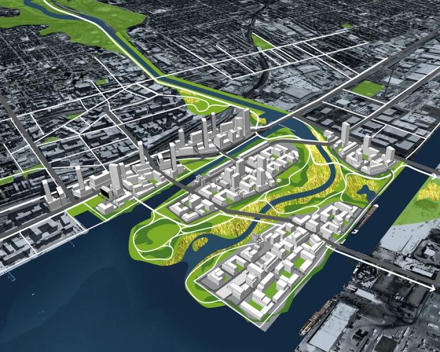
The original plan for the Port Lands was contingent on making the area floodproof in case of a massive storm that would overwhelm the Don River. Accomplishing that meant moving the mouth of the river from the Keating Channel to the Toronto Harbour, an immense undertaking with a price tag of more than $600 million — a sum Waterfront Toronto didn’t have.

Instead, this time around, landscape architect Michael Van Valkenburgh has taken a novel approach to flood protection, reconfiguring the proposal so flood protection is phased in one area at a time. This also reduces the initial costs.

And it means parts of the 400-hectare Port Lands can be sold off for development, with the money used to build flood protection in another area.

“One thing that was very clear is that people wanted something started in the Port Lands, for something to come out of this exercise,” says Fletcher. “And to not have something to start with would be very sad.”

But she notes, “It doesn’t have to be all done at once,” and the proposal will be phased in over 30 years.

Currently, there’s no funding for the project. But David Kusturin, chief operating officer, says Waterfront Toronto’s business plan shows development revenues will cover a significant portion of the costs.

Other money may come through loans from the city or province. There’s also a new revenue idea: instituting area-specific development charges to offset infrastructure costs.

The agency said it consulted with developers, who have indicated they are willing to help pay for services such as water and sewer. “It makes sense for us to proceed,” Kusturin says.

The plan calls for a bus rapid transit line that will eventually be replaced with light rail. The city is currently looking at many ways to increase overall transit funding, including road tolls and gas or sales taxes. An extended transit package expected this fall will include the BRT proposal as well as the East Bayfront streetcar line along Queens Quay, explains deputy city manager John Livey.

An environmental assessment of the new proposal could be approved within the next 12 to 18 months, says Fletcher, who will push city council for the $65 million needed to create flood protection in phase one.

In that phase, the northwest corner of the Port Lands, south of Lake Shore Blvd. and west of Cherry St., will be developed at a total cost of $447 million, including $267 million in infrastructure costs. The site will be raised slightly higher.

Flood protection involves building a spillway along the Don Roadway, east of the area, to absorb excess flow in the event of flooding.

The mouth of the Don won’t be relocated until phase three of the bigger project.

The Port Lands area is almost as big as the region from Dundas St. to the lake and from Bathurst St. to Parliament St. The soil must be cleaned because it’s contaminated from years of industrial use, and because the area is largely infill, the bedrock lies 10 to 20 metres below the surface, which increases construction costs.

Planning for this project “has been arduous and very tough,” says Fletcher. “The public scrutiny is very high, as it should be. At the end we’ve got something pretty darn good.”

The new proposal will go to the executive committee in September and city council a month later.
Before:
urbantoronto-2937-8313.jpg

from: http://urbantoronto.ca/database/projects/lower-don-lands-redevelopment

Now:
6c8545a946d98c8b95a197eeed6f.jpg

from: http://i.thestar.com/images/2d/7f/6c8545a946d98c8b95a197eeed6f.jpg
 
More news today (but mostly re: financing and timelines):

http://www.torontosun.com/2012/08/08/updating-tos-waterfront-vision

http://news.nationalpost.com/2012/0...e-sector-to-fund-redevelopment-of-port-lands/

http://www.theglobeandmail.com/news...ization-plan-to-take-30-years/article4470796/

Excerpts from the GLobe:

...

“The planning of a city is not like the design of a building or a park in the sense that it evolves,” Mr. Van Valkenburgh said on Wednesday, explaining changes required to his 2007 designs to accommodate the existing users and the Toronto Port Authority.
The park that once would have jutted into the harbour has been replaced with a “harbour plaza” beside the existing harbour wall. Two new sites for “catalyst uses” were added, one on the south side of the new river mouth and the other near the existing Keating Channel.

These sites would be ideal for “civic venues” such as museums, he said.

New renderings of the site include ships tied to the dock wall during winter and a vessel moored beside the Lafarge cement facility, the plant visible above the foliage of the trees that line the new river mouth.

...

“It is just a time we are in,” he said. “Everybody still wants magic, but everybody wants it to cost less.”

...

The new plan also has several financing options, including land sales, area-specific and city-wide development charges, local improvement charges and new funding sources dedicated to transit, most of which require the approval of city council.

This latest report, along with recommendations from staff, will be presented to Mayor Rob Ford’s executive committee next month and to council in October. After that, provincial environmental approvals are expected to take another nine to 18 months.
 
Last edited:
I wasn't clear. The new proposal is to construct a spillway from the Don at Keating channel to the shipping channel, in order to permit condo construction. 416 argued that this spillway should be counted as parkland constructed in phase 1, not phase 3 (or this is how I read "it is not possible that a park will not be built before all development is complete").

But most of the phase 1 spillway is to become the new riverbed in the perhaps-mythical phase 3. So it is hard to imagine that there will be much investment in landscaping of this space to make it attractive, accessible, and useful to park goers. The best we can hope for until the perhaps-mythical phase 3 is something like the Finch hydro corridor I think.
 
Thanks for being the voice of the cynic, k10ery. Somebody has to represent the reactionaries who weren't at the meeting/who didn't watch the webcast/who didn't read the full report, yet who are still certain they know what is going to happen, and that it isn't going to be good. I'd take your word over this backwoods Michael van Valkenburgh any day.
 
This appears to be an excellent compromise solution, since it recognizes that this is still, to a certain degree, a working port ... and adapts the new forms to that reality. In that sense, it's like the Pier 27/Redpath refinery/Sugar Beach/Corus Quay/Sherbourne Common sequence where established industrial uses are incorporated with the new.
 

Back
Top