News   Jun 07, 2024
 333     1 
News   Jun 07, 2024
 212     0 
News   Jun 07, 2024
 346     0 

Toronto Crosstown LRT | ?m | ?s | Metrolinx | Arcadis

But as it would cost more (so everyone says) to switch to "actual" subways although they are going below ground anyways, why would Doug Ford even mention subway? I would imagine they would want as much savings as possible for his sheppard subway that Rob Ford thinks that by catering to Scarborough and North York (north 401) will get him re-elected. He probably is confusing subway, LRT. streetcar because otherwise since the Fords keep saying Toronto wants subways why does no one mention to them that Eglinton is not getting "subways" and see what he says. If LRT is good enough for Eglinton then LRT is good enough for Sheppard. There is no way Sheppard should get a subway ahead of Eglinton.

Actually subway rolling stock is cheaper than trams.

If you're tunneling the whole thing anyway, using subway trains would be cheaper. The only advantage of LRVs is that you can use them at-grade on the street.

It already did.

pwn'd!
 
Rob Ford thinks that condos will easily go up along Eglinton to help pay for the underground section east of Laid through development fees. (Mississauga kept its property tax down because of development fees, but is now running out of undeveloped land.) He must have a bad memory or was too young to remember the Quebec-Gothic battles over high-rise buildings in the High Park area of Bloor Street.

See this link. And this link, from which this quote is from:

High Park North is bounded on the south by Bloor Street, on the west by Runnymede Road, on the north by Annette Street, Quebec Avenue and Humberside Avenue, and on the east by the CNR/CPR railway tracks. It is located in the Parkdale-High Park provincial and federal ridings. The area east of Keele Street is also known as the "West Bend" neighbourhood informally.

High Park north is mainly residential, containing many semi-detached homes built in the early 20th century. North of High Park, the neighbourhood has several high-rise apartment buildings, built after the construction of the Bloor-Danforth subway. Bloor Street is the main east-west thoroughfare. It is a four-lane road and is commercial in with storefront-type businesses with residential second and third storeys. North-south roads include Keele Street and Dundas Street. Both are primarily residential within the neighbourhood.

High Park North falls entirely within the boundaries of the town of Toronto Junction, which was purchsed from the Keele estate in 1882 by Daniel Clendenan who subdivided the farm and racetrack for a residential district (now called High Park North) to serve the Junction commercial district. As Bloor Street was still an uneven and a mostly undeveloped street, early housing in the area was concentrated to the north and east, where it was easier to access the stores and industry along Dundas Street and High Park Ave in particular was the site of many early homes of the Junction wealthy, as was modern Evelyn Crescent; many of these houses are still standing. High Park North emerged as a neighbourhood once Bloor Street was widened and evened out following World War I, when most of the residential homes which still exist today were built.

In 1915, Bloor Street was the site of a major public works at the north-west corner of High Park. The street, west of High Park Avenue, was crossed by creeks that emptied into Grenadier Pond. The creek banks were steep, making the roadway treacherous and difficult for traffic. A rail trestle was built to cross the gap at a level of 60 feet. The rails were used for rail cars to dump soil around the trestle. The trestle was completely buried and the present Bloor Street roadway built on top. Existing north-south roadways connecting to Bloor Street were raised to meet the new level of Bloor Street and this facilitated the development of the neighbourhood.

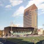
In the 1960s, the area directly north of High Park was the site of 'block-busting' development. The residences on High Park Avenue, Quebec Avenue and Gothic Avenue were bought up by developers; razed and large apartment buildings were built. The area from north of the subway line to Glenlake Avenue is now almost entirely high-rise towers. At the time, the City government was very much pro-development, and there were no local ratepayer/community associations as is seen today. By the 1970s, local residents formed associations in harmony with new reform Council members, partly to fight the block-busting north of High Park.

Developers are continuing to operate in the neighbourhood. 'Block-busting' has continued with the current controversial slated development on the north side of Bloor one block east of High Park Avenue, between Pacific and Oakmount, where a block of Edwardian-era homes has been purchased by developers with the exception of one, well publicized 'hold out'; this would be the first block of older homes directly on Bloor Street to be demolished for apartment building.

Those people who want an underground rapid transit near them, beware what you wish for. Your own home or your neighbour or others could be bought or expropriated for a high-rise to help pay for putting it underground.
 
Last edited:
Maybe while he's at it, Mihevic can waste some more time and get a legal opinion of that epic "Quebec-Gothic battle".
 
Those people who want an underground rapid transit near them, beware what you wish for. Your own home or your neighbour or others could be bought or expropriated for a high-rise to help pay for putting it underground.

Um that's good right?
 
Um that's good right?

The people in the High Park area did not have local ratepayer or community associations until the developers began to start to build the high-rises. After the high-rises, the local residents formed associations along with new reform members of Council, one of them was David Miller. In other words, in attempting to build high-rises along Eglinton (and Sheppard) will result in more reform or left-leaning councillors as high-rises sprout. That's why "be careful of what you wish for" Rob.
 
The people in the High Park area did not have local ratepayer or community associations until the developers began to start to build the high-rises. After the high-rises, the local residents formed associations along with new reform members of Council, one of them was David Miller. In other words, in attempting to build high-rises along Eglinton (and Sheppard) will result in more reform or left-leaning councillors as high-rises sprout. That's why "be careful of what you wish for" Rob.

But Eglinton, particularly outside of the central stretch, has a lot more big box commercial and old industrial properties (I'm thinking the Caledonia area for example). It's much easier to do a comprehensive redevelopment on properties like this, because you aren't expropriating someone's home to do it. These properties are owned by businesses, and if it makes business sense for them to sell it, they will sell. This especially holds true if it's a chain store, because there's even less sentimental attachment by the company compared to a family-owned business.

These types of properties don't exist along Bloor, at least not until you get out past Kipling. The example you brought up is a valid comparison for Eglinton between say Dufferin and Bayview, but outside of that there are a lot of non-residential properties that are ripe for redevelopment if an LRT station were to be put in the area.

This is why I think adding in some stops on the Georgetown line between St. Clair and Fort York would be great. There are so many under-used industrial properties along that stretch that can be redeveloped into some pretty intense TOD neighbourhoods.

What I hope they do with Eglinton is around every station, identify properties that could potentially be redeveloped, and create Secondary Land Use Plans for the area around every stop along the line.
 
But Eglinton, particularly outside of the central stretch, has a lot more big box commercial and old industrial properties (I'm thinking the Caledonia area for example). It's much easier to do a comprehensive redevelopment on properties like this, because you aren't expropriating someone's home to do it. s.

What I hope they do with Eglinton is around every station, identify properties that could potentially be redeveloped, and create Secondary Land Use Plans for the area around every stop along the line.
The problem is those homes whose backywards face Eglinton way up high on a hill west of Caledonia (with those small businesses in front at street level). You can get rid of those businesses which i think are just auto related and try to build condos but the depth from the sidewalk to the back of those small buildings is very small and the the height I would think would cut into those hills which at the top are the backywards of those homes. Obviously the homes face an inner street looking south. Which means you would have developers trying to buy those homes and probably succeeding and then that inner street has these condos and the whole thing starts.
 
According to the Allen Road-Eglinton West Station presentation (PDF download), the south entrance has been changed from automatic entrance to potential future entrance/exit (pending development at police station parking lot). In other words, it might not happen.

BTW. The original Eglinton Subway project would have ended at its east end terminal at Allen Road and only trail tracks would have continued east for a few short blocks.
 
Last edited:
According to the Allen Road-Eglinton West Station presentation (PDF download), the south entrance has been changed from automatic entrance to potential future entrance/exit (pending development at police station parking lot). In other words, it might not happen.

BTW. The original Eglinton Subway project would have ended at its east end terminal at Allen Road and only trail tracks would have continued east for a few short blocks.

as someome who lives kn the south side and has to make that stupid walk to the north side to the island first and then to the station,i was really reallly looking forward to the station on the south side.

other notes - how big a condo can fit behind the station entrance on the east parking lot land? why is there no room for a condo on the west side of the land? i didnt know the police station site was even a option to be redeveloped. i know with the lawrence heights redevelopment that lawrence was requesting a police station. could this station be moving? will beth shalom be a potential condo site?

btw im really upset there wont be a station entrance on the south side and i will be writing a letter in.

Well I believe the early bird gets the prize and in this case that was the developers.
 
I would so terminate the Allen at Lawrence. It would make the construction of this station so much easier and they would have a place to put the TBM spoil. And when it was complete and levelled off, what would acres of new real estate do to the bottom line of this project. Think of it as a road toll.
 

Back
Top