News   May 02, 2024
 159     0 
News   May 01, 2024
 1.7K     1 
News   May 01, 2024
 411     0 

Cycling infrastructure (Separated bike lanes)

It's on Bayview -- not open for the public yet.
Where?
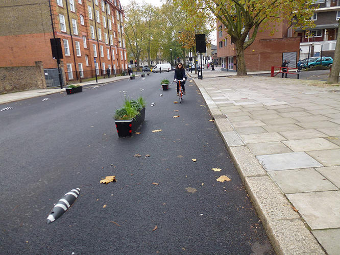
[I found the trail surprisingly narrow with a few misplaced hydro poles in the trail itself. It seems as though there will be some sort of barrier between the roadway and the cycle path (right now there are just a bunch of large orange pylons). However, it is much better than nothing and helps connect the Brick Works to surrounding neighbourhoods.]

If it's on the east side of Bayview headed south, how does that connect it to the "surrounding neighbourhoods"?

There used to be a trail in from the road on the east side of Bayview in that area, starts north of the Bloor viaduct, walked a dog up it a few months back to get to the Brickworks. That's been there for two decades. Is that no longer extant? It's problematic in only being accessible from the east side of Broadview.

Doubling checking again:
[Toronto's newest cycle path must be Bayview Ave from Rosedale Valley Road to Pottery Road. The paving finished up last week, and the connection to the east side Don Valley trail via a new pedestrian bridge is to be completed this autumn.]
Can someone be more specific on this?
 
Last edited:
Just north of Rosedale Valley Rd. Pics taken from Facebook.
Screen Shot 2016-09-06 at 7.07.10 PM.jpg
 

Attachments

  • Screen Shot 2016-09-06 at 7.07.10 PM.jpg
    Screen Shot 2016-09-06 at 7.07.10 PM.jpg
    313.8 KB · Views: 976
Pics on Facebook don't do it for me, so here's what some digging shows:
[...]
The design features a two-way pedestrian and cycling roadway on the east side of Bayview that is separated by a metal and wood “guide rail.” Previously, riders were forced onto paved shoulders to get to the Brickworks, and would have to sidle up to cars driving at 70 km/h. This multi-use trail will provide continuous access from Pottery Road to Rosedale Valley Road.

The lanes will not go as far as Leaside, but a 1-km-long paved shoulder will run from Bayview to Nesbitt Drive to Pottery Road. There is also access to Crothers Woods Trail at that point, should you want to take a route that does not require biking on a road with motor vehicles. [...]
http://dandyhorsemagazine.com/blog/2016/08/17/meanwhile-on-bayview/


Maps from the official City of Toronto Plan.

I have trepidations as to how the crossings go. Ostensibly, they will be full stop lights for both motorists and cyclists. The poles that show in the Facebook pics are cause for concern. What could possibly go wrong?
 
So I saw something VERY similar to these on Sherbourne today! Looks like the city has added something new to their inventory!

3025799-slide-p1010842.jpg


It's at Sherbourne and Isabella, right where the parking/loading zone by Shoppers is. It's more square and taller than these, but same concept.
 
Last edited:
So I saw something VERY similar to these on Sherbourne today! Looks like the city has added something new to their inventory!


It's at Sherbourne and Isabella, right where the parking/loading zone by Shoppers. It's more square and taller than these, but same concept.
Keep me posted! JUst got a reply from Cressy's office on an eml I sent weeks back, I forwarded the info on these to them.

Fingers crossed! I'm off doing distance, Cambridge to Hamilton, rail trail via Paris, Brantford, got to keep the muscles pumped. I'm freakin addicted!
 
For those interested in the East Don Trail extension, discussed a few pages back, here is a link to an update on the EA: http://www1.toronto.ca/wps/portal/c...nnel=3a178dd3f2ce1410VgnVCM10000071d60f89RCRD

It was found that underpasses for a couple of crossings of the Richmond Hill GO line were not feasible. Bridges will be built instead.

This seems to be quite an expensive proposition.
11 - River Crossings
2 - Bridges over railway
2 - tunnels
1 - underpass

All those structures are going to increase the cost of this trail connection significantly. Not to mention the increased construction costs of working in a relatively isolated and environmentally sensitive area. Has this been funded already? By all meanscomplete the EA for the whole stretch but I see this being built in phases, if at all.

The tunnels and underpass are very close to the Don and seem likely to be very susceptible to flooding, it seems like hundreds of mature trees will need to be removed in order to accommodate the trail.

From a very cursory look this does not seem like a prudent way to spend scarce bicycle infrastructure funding. A connection to and multi-use path alongside Linkwood/St. Dennis makes way more sense to me as a solution to the "missing-link".

I don't understand why they didn't use at-grade crossings (with arms). Would save millions. And the RH line doesn't have that much traffic right now. The bridges should only be added when there's sufficient traffic (bike or rail) to warrant.
 
^Metrolinx has a policy of no new at grade crossings.

The original EA had two level crossings, they have revised the environmental assessment to eliminate these and replace them with two bridges.
 
This seems to be quite an expensive proposition.
11 - River Crossings
2 - Bridges over railway
2 - tunnels
1 - underpass

All those structures are going to increase the cost of this trail connection significantly. Not to mention the increased construction costs of working in a relatively isolated and environmentally sensitive area. Has this been funded already? By all meanscomplete the EA for the whole stretch but I see this being built in phases, if at all.

The tunnels and underpass are very close to the Don and seem likely to be very susceptible to flooding, it seems like hundreds of mature trees will need to be removed in order to accommodate the trail.

From a very cursory look this does not seem like a prudent way to spend scarce bicycle infrastructure funding. A connection to and multi-use path alongside Linkwood/St. Dennis makes way more sense to me as a solution to the "missing-link".
I initially thought same until reading the link provided by Jaybe. My trepidation for draining the budget for Toronto cycle-paths was also a concern, until realizing this is from a different budget, and only partially City. The TRCA is the main source of funding, and it might well be matched by the Feds, I don't exactly know.

Studying the length of this link, where it is, and the incredible possibilities of through connections to other valuable paths to get across town, and maybe even cycle into Toronto from the east (there is only one gateway I know of, and I've been studying this and cycling it for years, and that's via Rouge Hill, and even there, there's a few missing links, albeit short ones). Yes, it is going to be a bit pricey, but considering how cycling has been getting shafted in this city for, well, close to a century, including the sad joke on Bloor St, I welcome this at any reasonable price.

For those reluctant to visit the link:
Download PDF version of Update

BACKGROUND

As you know, the City of Toronto and TRCA are conducting a Schedule C Municipal Class Environmental Assessment (EA) to study options for a multi-use trail system within the East Don Corridor. The proposed trail would provide a key connection in the multi-use trail network joining the existing East Don Trail (East of Wynford Heights Crescent), Gatineau Corridor Trail (at approximately Bermondsey Road), and the Lower Don Trail System.

STATUS

In our last update (August 2016) we indicated that a few segments of the trail still required utility landowner approval these included two crossings of the Metrolinx rail line, one within the Hydro Corridor and one north of Eglinton Avenue. At these two crossing locations the rail line is not high enough to provide sufficient space to construct a tunnel under the rail line. During the Environmental Assessment (EA) process options explored to cross the rail line in these locations included at-grade and bridge crossings. The preliminary preferred method of crossing was evaluated to be at-grade crossings, however following discussions with Metrolinx these cannot be selected as the final preferred. Metrolinx/GO’s policy direction is to not permit any new at-grade crossings of active rail corridors. Therefore the second highest evaluated crossings, bridges, have been selected as the final preferred crossing for these two rail line crossing locations.

EAST DON TRAIL PREFERRED DESIGN CONCEPT

The previously presented preferred trail design concept for the East Don Trail remains the same, except for the amendment of the two at-grade crossings to two rail line bridge crossings. The preferred option of crossing the Metrolinx rail line at three additional locations also remain unchanged and include two tunnel crossings and one underpass. The final preferred trail design concept, including the two rail line bridges can be seen in the map provided below.

RAIL LINE BRIDGES

Both bridges will be designed and built to span the Metrolinx right-of–way, ranging from 45 to 60m long, the specific sizing of these crossings will be completed in the detailed design project phase. Both bridges will aim to meet a minimum of 7.4 m vertical clearance, the distance from the rail line to the bottom of the bridge structure. Bridge width will be determined with the function of a multi-use trail in mind, aiming for a width of at least 3.5 m.

Further design and implementation considerations may include: bridge surface material type to consider an anti-slip surface, railing height and design to consider safety of trail users and rail line operations, bridge abutments and load requirements.

To transition trail users from the trail at ground level to the bridges over the rail line three design approaches will be explored: multi-use trail switchbacks, sloped walkways, and raised ramp structures. The specific dimensions for each of these will be determined during the detailed design project phase, and will consider: grades, number and location of landings/resting areas, handrails, guards, length, width, and turn radius.

The design of the bridges and transition areas will be done in consultation with Metrolinx and will work to meet the Ontario Accessibility Standards for the Design of Public Spaces Guidelines (2013), the Toronto Multi-Use Trail Design Guidelines (2014), City of Toronto Accessibility Design Guidelines (2004), and all applicable Transport Canada and Metrolinx standards.

NEXT STEPS

The public and project stakeholders are being asked to review and provide comments on the recent changes to the East Don Trail preferred trail design concept which includes the two rail line bridges. Any comments are requested by Wednesday, September 21, 2016. Following this two week review period, any necessary changes or additions will be made to the proposed rail line bridge crossings and the Environmental Study Report (ESR) will be updated. The ESR will be filed with the Ministry of Environment and Climate Change for a 30 day public review period. For further information on the ESR process please see Frequently Asked Questions.

EDT_UpdateMap_9-9-2016.jpg
http://www1.toronto.ca/wps/portal/c...nnel=3a178dd3f2ce1410VgnVCM10000071d60f89RCRD

Many thanks for that Jaybe!
 
Last edited:
^Metrolinx has a policy of no new at grade crossings.

The original EA had two level crossings, they have revised the environmental assessment to eliminate these and replace them with two bridges.

I can almost envision how this will go:

2020, in Toronto.

City Of Toronto: "OK Metrolinx, we've done what you said, and at GREAT expense, built bridges over the Richmond Hill Line"

Metrolinx: "Oh? that thing? Didn't you get the memo? We are switching to the acquired Don Branch next year. Ha whoops"
 

Back
Top