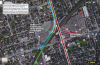
Toronto Ontario Line 3 | ?m | ?s

First problem I see is your portal and transition at Gerrard. You've drawn it in at about 450 feet long. But the drop from an elevated right of way to subway level is going to be 35 feet bare minimum, which at 2% grade for heavy rail is 1750. That takes the start of the transition back to Logan. Which puts the Carlaw and Gerard crossings, halfway down, at grade, so you have to close those roads. You might be able to to it in the green space between Queen and Dundas , as there seems to be a rise in the elevation towards Dundas.
 
Oh, I see. If the descent from elevated right-of-way to subway level could be extended to the full length of the blue arrow (drawn below), I estimate it would be about 400m (1300ft), but still not as long as you said was needed. If the grade could be greater than 2% and if the intersection of Gerrard/Carlaw could be lowered a bit, it might fit. It would be descending and curving, and the descending tunnel might have to protrude above the current residential street. The neighbourhood would be a construction zone for a while, and a strip of land would have to be taken from the No Frills strip mall. If something could be worked out with the property owners (e.g. density allowance), this entire mall area could be redeveloped at the same time.

If Gerrard Sq isn't workable, I like your other idea of having it go in near Jimmy Simpson Park (green space between Queen and Dundas), but more tunnel and more money I suppose. I can see how these projects get super expensive given the constraints.

Gerrard Sq DRL GO RH junction scheme modified.png
 

Attachments

  • Gerrard Sq DRL GO RH junction scheme modified.png
    Gerrard Sq DRL GO RH junction scheme modified.png
    2.8 MB · Views: 1,076
Last edited:
Oh, I see. If the descent from elevated right of way to subway level could be extended to the full length of the blue arrow, I estimate it would be about 400m (1300ft), but not enough. Is the 2% grade a maximum? It would be descending and curving, and the descending tunnel might have to protrude above the current residential street, so the alternative you mentioned is prob better.

If Gerrard Sq isn't workable, I like your other idea of having it go in near Jimmy Simpson Park (green space between Queen and Dundas), but more tunnel and more money I suppose. I can see how these projects get super expensive given the constraints.

View attachment 74046

I like the idea of interlining it, but one would have to presume that this line would a some point in the future be upgraded to RER. If you only have 1 extra track for express service, you effectively close the door on this line ever being an RER line. I'd think it would be prudent to have 4 tracks if you were to do this.
 
why 1 track not possible for RER? you can still run this line as rush hour express and make it much more "express" than the adjacent Yonge subway to attract riders and relieve pressure. Our infrastructure is sufficient outside of rush hour. People can simply take the Yonge subway.
 
why 1 track not possible for RER? you can still run this line as rush hour express and make it much more "express" than the adjacent Yonge subway to attract riders and relieve pressure. Our infrastructure is sufficient outside of rush hour. People can simply take the Yonge subway.

Because RER is a two-way 15 minutes or better service. 1 track would become problematic.
 
I thought RER just means express..electrified train can be more express. It can be one-way 5-min but only in rush hour, given there is a subway line, probably two, just next to the corridor.
 
I thought RER just means express..electrified train can be more express. It can be one-way 5-min but only in rush hour, given there is a subway line, probably two, just next to the corridor.

From Metrolinx's website:
For years, Metrolinx has steadily increased GO Transit service with the goal of transforming from a rush hour commuter service to a two-way, all-day regional transportation service. Regional Express Rail (RER) will build on all the planning and infrastructure progress we have already made and fast-track future service expansion.

http://www.metrolinx.com/en/regionalplanning/rer/rer_work.aspx
http://www.metrolinx.com/en/regionalplanning/rer/rer_service.aspx
 
Great work, ponyboy! I've proposed something very similar in the past, and I still think it's the best way to go. The DRL should be running RER rolling stock, not TTC, and thus be part of the RER network. The only change I would make to your schematic is to install an additional portal on LSE east of Gerrard Square, so that LSE trains have the option of using the DRL (what I call the Central Tunnel) as well.

This would allow for any combination of RER trains from various routes to choose whether to run express to Union (via the rail corridor) or local to City Hall (via the Central Tunnel). Naturally, there would be a similar type of arrangement around Queen & Dufferin.
 
The Relief Line Long has been added to Metrolinx's priority map
Only looks like Dundas West to Pape on Page 2, and then a thinner line to 407. Not sure how seriously to take that, given it doesn't show the Scarborough Subway extension either.

Isn't this just the Big Move projects?
upload_2016-4-28_15-40-20.png
But then on Page 18 it shows it from Yonge to Sheppard, and including the McCowan alignment of the Scarborough subway to Sheppard.
upload_2016-4-28_15-49-0.png

I'm waiting for the board meeting to be posted to ML's YouTube channel.
All the presentations are now linked from both the TTC website http://www.ttc.ca/About_the_TTC/Com...meetings/2016/April_27_Joint/Agenda/index.jsp and the Metrolinx website http://www.metrolinx.com/en/docs/agendas/agendas_2016_04_27.aspx
 

Attachments

  • upload_2016-4-28_15-40-20.png
    upload_2016-4-28_15-40-20.png
    149.2 KB · Views: 799
  • upload_2016-4-28_15-49-0.png
    upload_2016-4-28_15-49-0.png
    352.2 KB · Views: 763
The relief line in Metrolinx's presentation looks like it ends at Leslie Station/Oriole GO not Don Mills Station.
 
Only looks like Dundas West to Pape on Page 2, and then a thinner line to 407. Not sure how seriously to take that, given it doesn't show the Scarborough Subway extension either.

Isn't this just the Big Move projects?
View attachment 74250
But then on Page 18 it shows it from Yonge to Sheppard, and including the McCowan alignment of the Scarborough subway to Sheppard.
View attachment 74251


All the presentations are now linked from both the TTC website http://www.ttc.ca/About_the_TTC/Com...meetings/2016/April_27_Joint/Agenda/index.jsp and the Metrolinx website http://www.metrolinx.com/en/docs/agendas/agendas_2016_04_27.aspx

The map is hard to read, but it looks like the subway is on Don Mills to me.

Also notice that electrification of the eastern part of the CP line from the Junction to Agincourt is shown on the map. I don't recall seeing this on Metrolinx maps before.
 

Back
Top