|
|
|


You are using an out of date browser. It may not display this or other websites correctly.
You should upgrade or use an alternative browser.
You should upgrade or use an alternative browser.
Miscellany Toronto Photographs: Then and Now
- Thread starter Mustapha
- Start date


J T CUNNINGHAM
Senior Member
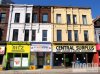
"Yonge Street, looking north from south of Shuter:"
Thecharioteer.
Too much "Restoration" on The Ryrie Building.
Regards,
J T
Thecharioteer.
Too much "Restoration" on The Ryrie Building.
Regards,
J T
thecharioteer
Senior Member
"Yonge Street, looking north from south of Shuter:"
Thecharioteer.
Too much "Restoration" on The Ryrie Building.
Regards,
J T
I'd still like to see the original cornice restored.
Attachments

Mustapha
Senior Member


thecharioteer
Senior Member


thecharioteer
Senior Member
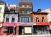
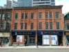
Five St. Joseph heritage:
2011:


2016:


2011:
2016:
Attachments
-
 Vacant-stores-at-Five-Condos-site-viewed-from-Yonge-at-Dundonald-April-9-2011-IMG_4825.jpg59.9 KB · Views: 1,175
 -
 Vacant-store-at-Five-Condos-site-viewed-from-Yonge-at-Dundonald-April-9-2011-IMG_4827.jpg57.1 KB · Views: 1,123
 -
 five2016a.jpg367.9 KB · Views: 1,228
 -
 fiveheritage2.jpg367.2 KB · Views: 1,181


Mustapha
Senior Member
I'm bored, so a capricious change of scenery. I'm driving, so you'll all have to come along. ")
This is the Graeter's ice cream restaurant on Main Street in Bexley (a suburb of Columbus, Ohio). My daughter and her family live in Columbus.
A couple of things on my mind today:
1. Toronto doesn't have any classy old school ice cream parlours. Not since Swensons left the Eaton Centre 25 years ago. All brass, tiles, mirrors, repro 1910s period lamps and great waitresses. We now only have Dairy Queen. And "Bubble Tea" joints. So I always take my granddaughter to Graeters.
2. Main Street here is something like our Hwy 11/Yonge street or Hwy 2/Kingston road. It started as an old pioneer road, laid over sections of, consecutively: Zane's Trace, The National Road, and US Route 40. You can look all this up. It was one of the first wagon routes west and was one of the original 1920s transcontinental highways. At one time it stretched from Atlantic City to San Francisco.
Think of it as a more northerly Route 66.
Anyways, I miss my granddaughter and what is basically a meal made of ice cream.
.jpg")
.jpg")
This is the Graeter's ice cream restaurant on Main Street in Bexley (a suburb of Columbus, Ohio). My daughter and her family live in Columbus.
A couple of things on my mind today:
1. Toronto doesn't have any classy old school ice cream parlours. Not since Swensons left the Eaton Centre 25 years ago. All brass, tiles, mirrors, repro 1910s period lamps and great waitresses. We now only have Dairy Queen. And "Bubble Tea" joints. So I always take my granddaughter to Graeters.
2. Main Street here is something like our Hwy 11/Yonge street or Hwy 2/Kingston road. It started as an old pioneer road, laid over sections of, consecutively: Zane's Trace, The National Road, and US Route 40. You can look all this up. It was one of the first wagon routes west and was one of the original 1920s transcontinental highways. At one time it stretched from Atlantic City to San Francisco.
Think of it as a more northerly Route 66.
Anyways, I miss my granddaughter and what is basically a meal made of ice cream.
Attachments


Mustapha
Senior Member
Here's a Then - 1927, and Now - 2013 VIDEO of London. Enjoy.
http://www.photoxels.com/london-then-1927-and-now-2013/
http://www.photoxels.com/london-then-1927-and-now-2013/
Mustapha
Senior Member
Easter Friday is our first physical geography day at Urban Toronto. And you thought you got a day off from studies.
So, come sit on the pub stool beside me and I'll get just a tidge too close and give you today's lesson:
Below is the Don River. We're looking north west from the Gerrard street bridge. The green bridge yonder connects west and east Riverdale parks. Note the area in the distance where the yellow arrow is pointing - west Riverdale park. We'll walk over there in a moment.
*
.jpg")
The Don River here is nice and straight isn't it? It used to meander to and fro. It wasn't straightened so you could have a nice fast drive on the DVP; that was a later unintended benefit. It was straightened to aid industrial development in the early portlands.
If you look at UT-er "plink"s 1888 and 1890 maps at this link:
http://skritch.blogspot.ca/2012/04/goads-atlas-of-toronto-online.html
You'll see the before and after of the straightening.
Still with me?
Let's walk over to west Riverdale park. Look below, where my yellow arrow is pointing. It's a pond. That is actually the meander cut off as a result of the straightening. To use geography terminology I suppose you could call it an "oxbow." We are looking northeast.
*
.jpg")
You can also see this oxbow branch of the Don River from inside Riverdale Farm park. There's not much to see but your legs and heart will thank you for the workout. Don't go in high summer. The mosquitos down there are UFC trained.
See the 1888 map below for an 'aerial view'. I have circled in yellow the approximate area of the present oxbow.
*
.jpg")
It's ok, don't mention it.
So, come sit on the pub stool beside me and I'll get just a tidge too close and give you today's lesson:
Below is the Don River. We're looking north west from the Gerrard street bridge. The green bridge yonder connects west and east Riverdale parks. Note the area in the distance where the yellow arrow is pointing - west Riverdale park. We'll walk over there in a moment.
*
The Don River here is nice and straight isn't it? It used to meander to and fro. It wasn't straightened so you could have a nice fast drive on the DVP; that was a later unintended benefit. It was straightened to aid industrial development in the early portlands.
If you look at UT-er "plink"s 1888 and 1890 maps at this link:
http://skritch.blogspot.ca/2012/04/goads-atlas-of-toronto-online.html
You'll see the before and after of the straightening.
Still with me?
Let's walk over to west Riverdale park. Look below, where my yellow arrow is pointing. It's a pond. That is actually the meander cut off as a result of the straightening. To use geography terminology I suppose you could call it an "oxbow." We are looking northeast.
*
You can also see this oxbow branch of the Don River from inside Riverdale Farm park. There's not much to see but your legs and heart will thank you for the workout. Don't go in high summer. The mosquitos down there are UFC trained.
See the 1888 map below for an 'aerial view'. I have circled in yellow the approximate area of the present oxbow.
*
It's ok, don't mention it.
Attachments


Last edited:
Browning Avenue
New Member
Another installment of Yonge street 'Then [still 1973-ish] and Now' [today at 3:00pm]. We're looking east along Dundas towards Yonge.
View attachment 70258
More like early 1980s. It was about 1980-ish that they deleted the words "car" and "bus" from the TTC signs. and I'm pretty sure they still had "no turns" signs at least up to then before they replaced them with arrows.
old boy
Senior Member
Now, it looks like a canal.
Mustapha
Senior Member
Mustapha
Senior Member
Skeezix
Senior Member
Member Bio
- Joined
- Apr 25, 2007
- Messages
- 4,343
- Reaction score
- 2,688
- Location
- East of this, west of that
Toronto doesn't have any classy old school ice cream parlours.
Funnily enough, I just read this weekend about Bean and Baker on Harbord, reportedly Toronto's only malt shop. It looks kind of cool, although of course it's not original, but more of a nostalgia theme restaurant. Has anyone been?
The exterior of Graeters looks lovely.
donoreo
Active Member
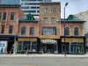
What a fabulous building.