News   May 17, 2024
 2.3K     3 
News   May 17, 2024
 1.5K     2 
News   May 17, 2024
 10K     10 

Waterloo Region Transit Developments (ION LRT, new terminal, GRT buses)

The Seagram/Laurier/Waterloo Park station got concrete forms today, so I'd imagine within a week we'll have a pour here.

12662536_10153497118587153_6186165725561142306_n.jpg


Double track now extends all the way South from the OMSF to University Ave, right through University of Waterloo. Just one short section between University and Seagram to go, and the whole Waterloo Spur will be track-complete.

12642684_10153497118612153_2843710059925826618_n.jpg


12647543_10153497118637153_5251386345130936475_n.jpg
 

Attachments

  • 12662536_10153497118587153_6186165725561142306_n.jpg
    12662536_10153497118587153_6186165725561142306_n.jpg
    114.9 KB · Views: 1,001
  • 12642684_10153497118612153_2843710059925826618_n.jpg
    12642684_10153497118612153_2843710059925826618_n.jpg
    148 KB · Views: 989
  • 12647543_10153497118637153_5251386345130936475_n.jpg
    12647543_10153497118637153_5251386345130936475_n.jpg
    103.2 KB · Views: 1,442
I'm thinking about doing a trip to K/W in a couple weeks to check out the LRT construction. Anyone have recommendations for "must see" spots?

Thanks!
 
You bet. Start in the North, work your way South.

  • Assuming you're coming from Ottawa, take 401, exit 278, North Highway 8, then stay in the right 2 lanes up 85 toward St Jacobs (the "Right" side of the Y of the Conestoga Parkway).
  • Exit at King and turn right. This will take you toward Conestoga Mall - your first stop. This is the Northern terminus of the line, and they've started working on the station a bit here (ground prep).
  • Keep going North, turn Left on Northfield. This whole stretch is dug up (down to 1 lane in each direction), no tracks yet, but soon.
  • Turn Left on Parkside. Pull into any of the parking lots along here (World Gym) and you're right next to the Operations, Maintenance and Storage Facility.
  • I recommend parking as close as you can to Weber and then walking up over the Overpass/Bridge over the tracks. A fantastic vantage point for the whole OMSF. If you keep walking and turn left on Dutton Drive, you can get right up to the entrance of the OMSF.
  • Get back onto Parkside and turn left (South). Cross Weber and at the next 4-way Stop, turn left behind Albert McCormic Arena. You can park there and take a peek at the tracks running there.
  • Keep going South on Parkside. You'll cross Bearanger, and enter David Johnston Research and Technology Park. At the First roundabout, exit left (270 degrees). At the second roundabout, exit 270 degrees and the first parking lot on your right is free on weekends. Park here and follow the trail next to the tracks North/South a bit. If you head North, after about 5 minutes you can check out the gauntlet track and platform at R&T Park. Head south and you'll walk toward University of Waterloo. No parking there for free so best to just walk this part if you can.
  • When you get tired keep heading South on Parkside and head through University of Waterloo (cross Columbia). Hang to the left of the ring road, and you'll drive right past the UoW station.
  • Keep heading South and the road crosses University Ave and becomes Seagram. It curves around to the right, and right when you cross the tracks you can park in the lot on your right, and walk this part of the route. Waterloo Park is great.
  • When you exit that parking lot, turn right on Seagram, then at the light you have to turn Right onto Erb which is a 4-lane wide 1-way road. Head straight through (it becomes Caroline) and park in the lot on your left (Waterloo Town Square) to explore this part of the line (Caroline).
  • At this point I would recommend going down Park St. since King is all closed up with so much work. A walk up and down King through "midtown" might be nice.
  • Alternatively keep driving down Park and you'll cross Victoria... keep going straight through. You'll drive through Victoria Park.
  • At the 4-way stop on the far side, keep going straight. Keep going straight through Queen, then the next turn is Left on Benton. Park on the right side of the road next to the Arrow lofts.
  • Walk up the hill and you'll be at Benton/Charles. Really neat crossing here. Go up the elevator in the Benton St. Parking Garage to the roof for a great vantage point North/South.
  • Now, if you're particularly adventerous, walk North (left) for a while and you can see all the new trackwork right up to Manulife. You can't miss the huge Dome going up at King/Victoria - future site of the transit hub, too.
  • Heading South from Benton/Charles you can walk the whole line all the way to Borden.
  • I'd recommend exploring a bit here then hopping back in your car and driving down either Courtland (Park becomes Courtland) or pop up Benton and turn Right (South) on Charles. It should be open...
  • Park somewhere on Borden and you can walk along there too to explore.
  • There isn't too much going on much past here. Courtland gets all messed up and is closed entirely further up for some ground prep work.
  • Nothing really going on at Fairview Mall.

See if this makes sense while following along in Google Maps - I can try and draw up a map if it would help you out!
 
Oops - sorry, I assumed you were driving from Ottawa. Others might have better ideas for exploring on foot (many of the Waterloo region folks who post here also post to WRConnected and are very pedestrian/cycle oriented - I'm personally not), but you can still see a lot if you use the GO/VIA station as your "home base" and walk mostly South from there.
 
Oops - sorry, I assumed you were driving from Ottawa. Others might have better ideas for exploring on foot (many of the Waterloo region folks who post here also post to WRConnected and are very pedestrian/cycle oriented - I'm personally not), but you can still see a lot if you use the GO/VIA station as your "home base" and walk mostly South from there.

I'll return the favor if you ever visit Ottawa to see the Confederation Line
 
It was so spectacularly warm yesterday that I went out and took some photos just for the sake of getting outside.

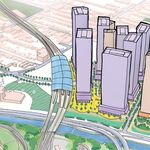
Looking north from Old Albert Street. This will make a neat filming angle with LRVs flying around the S curve at 70 km/h. The telephoto lens disguises how long this segment is and how wide the curves are.
24443027619_c17a908092_b.jpg


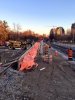
Old Albert Street crossing. Note that Old Albert is actually a bike path, which explains the narrow crossing blocks.
24183839613_72470218c7_b.jpg


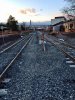
Bearinger Road crossing.
24515166440_ebe105e85b_b.jpg


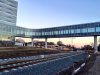
University of Waterloo station
24182527424_28a4a752f9_b.jpg


Thanks for putting that together! I'm in Toronto for school, so I will probably take GO in the morning and spend the day there.

I don't recommend GO for a day trip to KW from Toronto, probably look into Greyhound instead. GO is great for a day trip to Toronto from KW, but service is poor to non-existent in the opposite direction. The exception is Fridays or Sundays, when there is extra express service on route 25+ from Square One and route 25F from Bramalea and YorkU.

I personally do all my photo updates by bike, the Laurel Trail runs along the Waterloo Spur from roughly Bearinger Road to Erb Street and there are a bunch of bike crossings further north.

Ugh, crossing gates. No fun. It should be converted into a standard intersection but I guess that is complicated for sections that freight trains run over. Existing or not, crossing gates would be unwelcome for advocating continued LRT expansions, so if they need to keep these gates, then they need to run them at really, really short durations. How far in advance does this crossing close?

Railway crossings (with or without gates) are far superior to conventional intersections.
- They guarantee transit priority
- They respond more quickly because pedestrian clearance calculations are less generous.
- They are safer because of the more prominent barriers to crossing, especially if there are gates
- They don't take any more time away from the street than a normal intersection
 
Last edited:
Crossbucks and gates are common on the Edmonton and Calgary LRTs, even in median sections. The transit priority offered by full railway crossings is superior; they also reduce the chance of collisions.

Waterloo's ION will be an interesting hybrid with the Uptown Waterloo-Northfield Road section with full priority, and the King Street/Charles Street sections more mixed with traffic.

If you're interested in a day trip, and don't mind a late start to your day, you can ride VIA Train 85 - you'll get into Kitchener around 12:30. It's an interesting trip, and even at this time of year, you'll get 5-6 hours of daylight, enough to tour the construction.
 
Last edited:
  • At this point I would recommend going down Park St. since King is all closed up with so much work. A walk up and down King through "midtown" might be nice.

One spot around here I recommend is to walk up the stairs to the top level of the Grand River Hospital parking lot, provides a great view of the work on King St.
 
That's the Uptown Waterloo portion. The portion by Grand River Hospital is between Uptown Waterloo and Kitchener, and is well underway.
 
You bet. Start in the North, work your way South.
See if this makes sense while following along in Google Maps - I can try and draw up a map if it would help you out!

Thanks for that awesome list. A map would be helpful if you had time.
 
I don't understand that CBC report. Are they bringing later work into the current engagement and therefore avoiding the need for a further closure, or is the scope of the King St works widening?
 
I don't understand that CBC report. Are they bringing later work into the current engagement and therefore avoiding the need for a further closure, or is the scope of the King St works widening?

I think it's the first one, trying to get all utility relocation and track placement work done in one long closure so they don't have to go back and disrupt the street later.
 

Back
Top